

| Version 5 (modified by , 15 years ago) ( diff ) |
|---|
Другие языки:
Скачать с OSM
 Сочетание клавиш:
 Ctrl-Shift-D
Скачать данные с сервера.
Типы данных
Могут быть скачаны разные типы данных:
- данные osm (точки, линии, отношения...), которые могут быть скачаны с сервера OpenStreetMap.
- данные gps, ГЛОНАСС, котрые могут быть скачаны с сервера OpenStreetMap.
Тип выбирается в верхней части диалогового окна. (Можно сразу загрузить данные обоих типов).

Область для скачивания
В диалоговом окне присутствует несколько вкладок. Их точная конфигурация зависит от установленных у вас модулей, но в общем случае должно быть как минимум пять вкладок. При переключении вкладок область для скачивания не должна меняться. Так если вы выберете, например, Закладку и переключитесь на вкладку Быстрая карта, то выделится область, соответствующая выбранной закладке.
Примечание: Если вы уже загружали данные, то при открытии этого диалогового окна выделенная область для скачивания будет соответствовать границам видимой части карты в основном окне JOSM. Таким образом, типовой сценарий работы будет выглядеть следующим образом: сначала загружаете ваш GPS-трек из GPX файла, затем масштабируете вид таким образом, чтобы на экране отображался только нужный вам участок, и после этого запускаете диалоговое окно Скачать, в котором будет выделена область, видимая в основном окне JOSM.
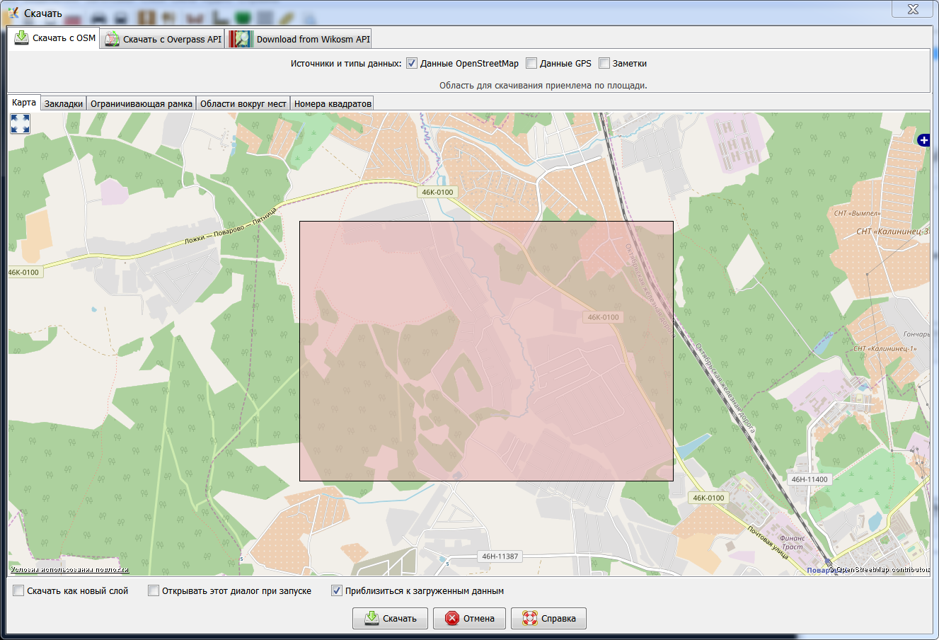
Быстрая карта
На вкладке "Быстрая карта" представлена карта (подобная карте с основной страницы сайта OSM), на которой вы можете выделить область для скачивания. Для перемещения карты используйте правую клавишу мыши, для выделения - левую.
Закладки
На вкладке "Закладки" вы можете выбрать одну из ранее созданных вами закладок или создать новую. Закладка создается по координатам текущей области для скачивания, выделенной на вкладке "Быстрая карта" или заданной на другой вкладке.
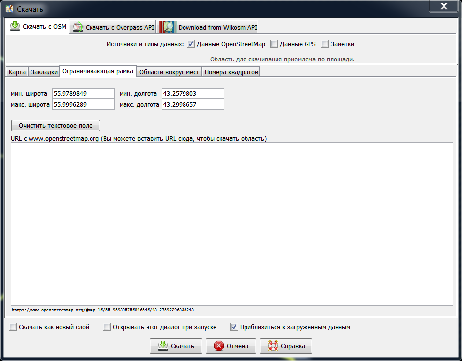
Bounding Box
A Bounding Box tab where you can set the latitude/longitude bounds of the data to be downloaded, and also paste an URL from either www.openstreetmap.org or www.informationfreeway.org.
- To paste from the map on the OpenStreetMap site, zoom in to the area you are interested in, then either move the mouse over the "view" tab, and copy the resulting URL, or copy the permalink given in the bottom right corner. Then go to JOSM, and paste this URL into the "URL from www.openstreetmap.org" box. (In Windows to paste into the box, left click within the box, and then do CTRL+v).
- To paste from www.informationfreeway.org zoom to the area you are interested in, and then copy the permalink location from the bottom right of screen, and paste as described above.
Area around places
On the Area around places tab you can find the functionality of the former namefinder plugin. Here you can search for specific places, street names, etc, in the OSM database. Currently there are two different servers for the search you can choose from:
- Nominatim
- (Namefinder: outdated, was used by the namefinder plugin.) service has been retired and shutdown.
Tile Numbers
A Tile Numbers tab where you can enter number of tiles and a zoom level to download data of those tiles. Alternatively you enter a Tile address. This might look a little awkward especially when reading how to compute the tile numbers. But sometimes it comes in handy. Have a look at the t@h browser where you can quite easily determine the tile numbers in the image address when hovering the individual tiles with the mouse.
Area too large
There will also be a red warning at the bottom left displayed if the selected area is too large for the server and will likely be answered with an error message. (You can try, though!)
Otherwise choose a smaller area. You can download bigger areas using several smaller ones.
Layer control
You can control whether the data is loaded into the current or in a new layer with the check box in the bottom left corner of the window:
- if Separate Layer is selected, the data is loaded in a new layer
- if Separate Layer is not selected, the data is loaded in the current data layer
If there isn't any data layer yet, a new data layer is always created.
See also
Attachments (10)
- download_dialog_ru.png (226.1 KB ) - added by 15 years ago.
- SlippyMap.png (366.9 KB ) - added by 9 years ago.
- Overpass.png (383.3 KB ) - added by 9 years ago.
- Wizard.png (138.2 KB ) - added by 9 years ago.
- Favorite.png (43.1 KB ) - added by 9 years ago.
- Wikosm.png (434.4 KB ) - added by 9 years ago.
- Bookmarks.png (87.8 KB ) - added by 9 years ago.
- BBox.png (68.2 KB ) - added by 9 years ago.
- AreaAroundPlaces.png (88.7 KB ) - added by 9 years ago.
- TileNumbers.png (278.8 KB ) - added by 9 years ago.