

| Version 29 (modified by , 10 years ago) ( diff ) |
|---|
Languages:
Filter dialog
 Keyboard shortcut:
 Alt+Shift+F
The filter dialog allows the user to disable or temporarily hide (hidden) from display certain types of objects on the JOSM screen. The usage is to enter any property or just text in the text box. Objects complying with that text or property will be hidden on your JOSM screen. This allows for easier editing in areas with densely located objects or infrastructure.
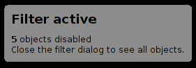
Filter warning
If any filter is active, a transparent message box will appear so you don't forget. It is only visible if at least one object was disabled or hidden.
Use cases
- DIY validator rules
Usability
- De-clutter the map by (de-)activating features only when you need them
- Completely hide features you don't use
- Avoid unnecessary or accidental edits
Productivity
- Disable/separate objects that were fully tagged (using tag count and custom filters) from incomplete objects
- Disable recently modified objects (and it is irrelevant: if it modified by you or another person)
- Untagged objects
untaggedcan be used instead of Notes at osm.org. It is faster than to set/removefixme=resurvey- please don't overuse this principle
Filter and columns
The filter lines are evaluated from top down, with respect to values in #Columns.

The E till I options are selected in the Filter box (normally at the right of your screen) by ticking the appropriate box. Note that the text line above the click boxes may contain dots in your particular version of JOSM. This will probably be fixed. The order of the ticks from left to right means: Enable this filter line / Hide the filtered items / Your search-filter text / The inverse filter / Mode letter.
- E (Enable): Enable or disable this filter line.
- H (Hide elements): If this option is ticked, the chosen objects are completely hidden. Otherwise they are disabled and shown in a shade of gray.
- Text: The search term or property that defines the objects that are filtered.
- I (Inverse Filter): Normally, the specified objects are hidden and the rest is shown. If this option is activated, only the specified objects are shown and the rest is hidden.
- M (Filter Mode) - see below
Filter mode
This mode selector defines how a filter is combined with the previous filter.
The filter Mode options are set in the pop-up window, where you will also enter the search text. A number of examples is provided.
replace selection (R)
Will effectively disable all filters above.
replace selection (A)
You most likely want this mode. Filters with this mode are independent of each other.
remove from selection (D)
Will un-filter all elements matched
find in selection (F)
Examples
| Filter text | Description or note |
((landuse:|natural:|leisure:|building:) | (role:outer|role:inner)) | Doesn't handle relations perfectly |
shop=* opening_hours=* | shop= + opening_hours= tagged objects |
shop=* name=* | shop= + name= tagged objects |
type:node -shop=* | All nodes expect shops. Geometry modification using mouse move disabled, but possible using other modes (ex. - Improve Way Accuracy mode (W)) |
(type:node | type:way | type:relation) (modified | user:Steve) | Hide objects if you are the latest editor (useful during mass re-tagging and semi-mechanical edits) |
-highway: | Everything except highway= tagged objecets |
type:node -user:d1g | All nodes expect |
man_made=pipeline | Pipelines |
natural=water | Water objects |
admin_level: | Admin boundaries |
boundary: | leisure: | landuse: | waterway: | amenity: | natural: | building: | De-clutters map, aggressive (sometimes you may want to keep buildings or amenity key) |
type:node & untagged | Make it easier to select ways |
modified | Quickly see your changes |
child (type:way & highway:) | All nodes that's part of a highway |
child (type:relation & (natural:|landuse:)) | All natural and landuse areas formed by relations |
-((highway | child highway | untagged | public_transport) & -(highway=footway | highway=path | highway=steps | highway=track)) | Only roads for public transport. Good for mapping bus networks. |
See also Help/Action/Search#Examples other examples. If you have some clever filters, add them here.
Regular Expressions
The filter supports Java Regex. For detailed Information see http://docs.oracle.com/javase/7/docs/api/java/util/regex/Pattern.html
Old JOSM versions
If the symbol is not there, check if your JOSM version is >= 3189. If it is still not visible, you can try setting displayfilter=true in the advanced preferences (and restart).
Back to Toggle Dialogs
Back to Main Help
Attachments (3)
- filterdialog.png (12.0 KB ) - added by 11 years ago.
- filters warning.png (2.3 KB ) - added by 10 years ago.
- autofilter.gif (9.6 MB ) - added by 9 years ago.