

| Version 13 (modified by , 4 years ago) ( diff ) |
|---|
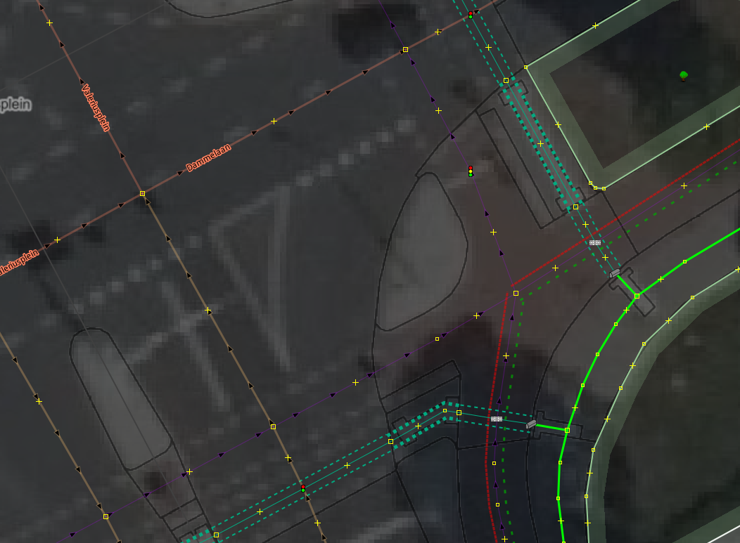
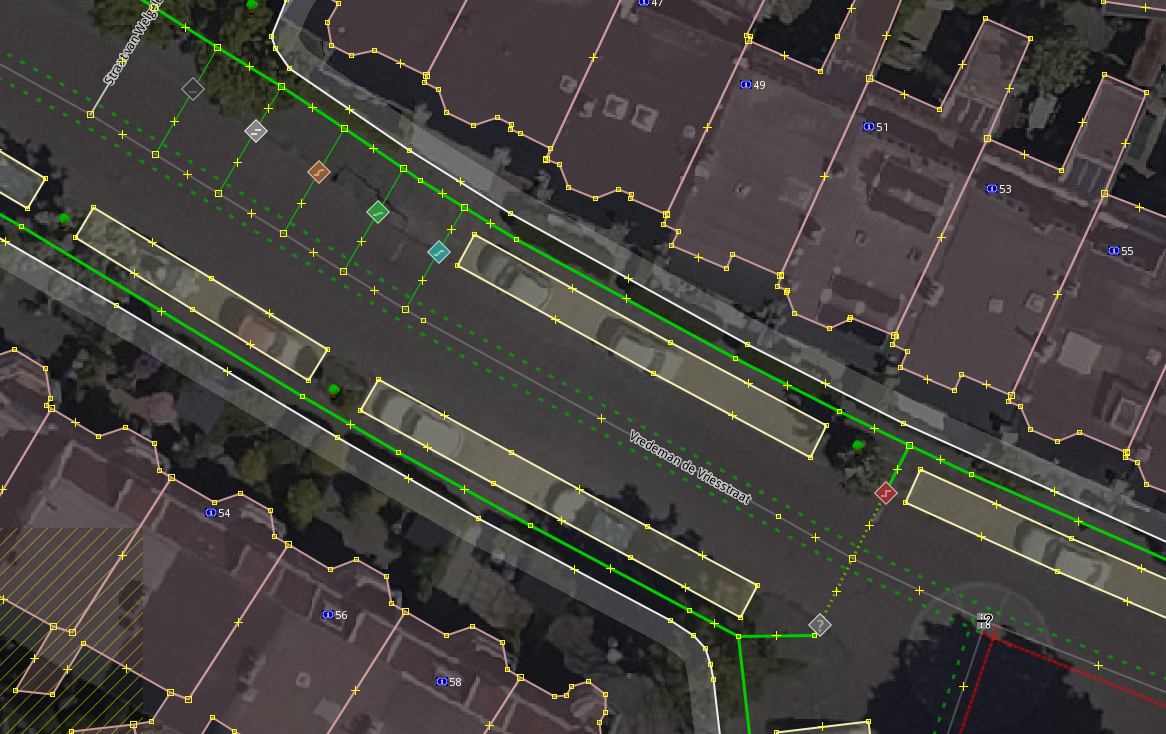
Useful for highlighting pedestrian affairs when mapping. Visualizes the sidewalk, sidewalk:left, and sidewalk:right tags of highways, and renders various highway=footway types specified via footway=* in different patterns. Ways that do not permit pedestrian use are (optionally) made translucent, making it easy to see that a tag like foot=no or foot=use_sidepath is applied.
")
Settings
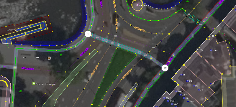
Some features of this Map Paint Style can be configured, such as the highlighting of ways that are part of hiking/walking routes. You can toggle these settings in JOSM.
")
Kerbs
When kerb=* is used on a node, an icon representing the value used is shown:
")
Notes
This style probably misses lots of useful functionality. Please let me know if you want to modify this style (if I don't reply within a reasonable span of time, go ahead and edit this style yourself).
meta {
    title: "Sidewalks and footways (with knobs on)";
    description: "Useful for pedestrian affairs. Visualizes the sidewalk, sidewalk:both, sidewalk:left, and sidewalk:right attribute of highways, and renders various highway=footway types in different patterns. Ways that do not permit pedestrian use are made translucent.";
    link: "https://wiki.openstreetmap.org/wiki/Key:sidewalk";
    icon: "silly-icon.svg";
    author: "Jeroen Hoek";
    version: "1.16_2023-12-17";
    min-josm-version: "17428";
}

/*
    This style is a fork of https://josm.openstreetmap.de/wiki/Styles/Sidewalks

    Because this style introduces more features than the above I have forked it for now. If the author of the original is willing the two may be combined in the future.
*/

meta[lang=de] {
    title: "Geh- und Fußwege (mit allen Schikanen)";
    description: "Praktisch für Fußgängerangelegenheiten. Visualisiert die Tags sidewalk, sidewalk:both, sidewalk:left und sidewalk:right und zeichnet die verschiedenen Arten von highway=footway mit unterschiedlichen Mustern. Straßen die für Fußgänger nicht zugänglich sind werden durchscheinend gemacht."
}

meta[lang=ja] {
    title: "歩道とサイドワーク(一切合切版)";
    description: "歩行者との関連のあるものに便利です。「sidewalk」と「sidewalk:both」と「sidewalk:left」と「sidewalk:right」というタグの可視化し、「highway=footway」の様々な種類を色々な模様に示します。歩行者が歩けない道は半透明にします。";
}

meta[lang=nl] {
    title: "Stoepen en voetpaden (met alles dr'op en dr'an)";
    description: "Handig voor voetgangerszaken. Visualiseert de sidewalk, sidewalk:both, sidewalk:left, en sidewalk:right tags, en tekent de verschillende highway=footway soorten met verschillende patronen. Wegen waar voetgangers niet mogen komen worden doorschijnend gemaakt.";
}

/*
    Settings.
*/

setting::highlight_routes {
  type: boolean;
  label: tr("Highlight ways part of trails and other hiking routes");
  default: true;
}

setting::highlight_rwn_nodes {
  type: boolean;
  label: tr("Show the node names of recreational walking node networks");
  default: true;
}

setting::no_foot_translucent {
  type: boolean;
  label: tr("Make ways without pedestrian access translucent");
  default: true;
}

setting::show_kerb {
  type: boolean;
  label: tr("Show kerb transition values on nodes");
  default: true;
}


/*
    The sidewalk=*, sidewalk:both=*, sidewalk:left=*, and sidewalk:right=* tags.
*/

way[sidewalk]::sidewalks_right,
way["sidewalk:both"]::sidewalks_right,
way["sidewalk:right"]::sidewalks_right {
    width: 3;
    dashes: 5, 1;
    offset: min(eval(0 - 10 - (prop("width") * 0.5) - (prop("width", "default") * 0.5)), -10);
}
way[sidewalk]::sidewalks_left,
way["sidewalk:both"]::sidewalks_left,
way["sidewalk:left"]::sidewalks_left {
    width: 3;
    dashes: 5, 1;
    offset: max(eval(10 + (prop("width") * 0.5) + (prop("width", "default") * 0.5)), 10);
}

way[sidewalk=right][!"sidewalk:right"][!"sidewalk:both"]::sidewalks_right,
way[sidewalk=both][!"sidewalk:right"][!"sidewalk:both"]::sidewalks_right {
    set sidewalk-yes;
}
way[sidewalk=left][!"sidewalk:left"][!"sidewalk:both"]::sidewalks_left,
way[sidewalk=both][!"sidewalk:left"][!"sidewalk:both"]::sidewalks_left {
    set sidewalk-yes;
}

/* left and no mean no sidewalk on the right if sidewalk:right is not set. */
way[sidewalk=~/^(left)|(no)$/][!"sidewalk:right"][!"sidewalk:both"]::sidewalks_right {
    set sidewalk-no;
}
/* right and no mean no sidewalk on the left if sidewalk:left is not set. */
way[sidewalk=~/^(right)|(no)$/][!"sidewalk:left"][!"sidewalk:both"]::sidewalks_left {
    set sidewalk-no;
}

way[sidewalk=separate][!"sidewalk:right"][!"sidewalk:both"]::sidewalks_right {
    set sidewalk-separate;
}
way[sidewalk=separate][!"sidewalk:left"][!"sidewalk:both"]::sidewalks_left {
    set sidewalk-separate;
}

/* More specific values can override the general sidewalk=* tag. */

way["sidewalk:both"=yes][!"sidewalk:left"]::sidewalks_left {
   set sidewalk-yes;
}
way["sidewalk:both"=yes][!"sidewalk:right"]::sidewalks_right {
   set sidewalk-yes;
}

way["sidewalk:both"=no][!"sidewalk:left"]::sidewalks_left {
   set sidewalk-no;
}
way["sidewalk:both"=no][!"sidewalk:right"]::sidewalks_right {
   set sidewalk-no;
}

way["sidewalk:both"=separate][!"sidewalk:left"]::sidewalks_left {
   set sidewalk-separate;
}
way["sidewalk:both"=separate][!"sidewalk:right"]::sidewalks_right {
   set sidewalk-separate;
}

/* sidewalk:left and sidewalk:right are more specific than sidewalk:both, so they override previous values. */

way["sidewalk:left"=yes]::sidewalks_left {
   set sidewalk-yes;
}
way["sidewalk:right"=yes]::sidewalks_right {
   set sidewalk-yes;
}

way["sidewalk:left"=no]::sidewalks_left {
   set sidewalk-no;
}
way["sidewalk:right"=no]::sidewalks_right {
   set sidewalk-no;
}

way["sidewalk:left"=separate]::sidewalks_left {
   set sidewalk-separate;
}
way["sidewalk:right"=separate]::sidewalks_right {
   set sidewalk-separate;
}

/* Styling. */

way.sidewalk-yes::sidewalks_left {
    color: #00cc00;
}
way.sidewalk-yes::sidewalks_right {
    color: #00cc00;
}

way.sidewalk-separate::sidewalks_left {
    color: #00aa00;
    dashes: 5, 10;
    opacity: 0.7;
}
way.sidewalk-separate::sidewalks_right {
    color: #00aa00;
    dashes: 5, 10;
    opacity: 0.7;
}

way.sidewalk-no::sidewalks_left {
    color: #ff0000;
    opacity: 0.5;
}
way.sidewalk-no::sidewalks_right {
    color: #ff0000;
    opacity: 0.5;
}

/* Values of kerb=* when used on nodes part of a way. */

node|z-21[kerb][setting("show_kerb")] {
    symbol-shape: circle;
    symbol-fill-color: #636363;
    symbol-size: 10;
    symbol-stroke-width: 1;
    symbol-stroke-color: #D3D3D3;
}
node|z-19[kerb][setting("show_kerb")] {
    symbol-shape: square;
    symbol-size: 4;
    symbol-stroke-width: 0;
}
node|z-21[kerb=raised][setting("show_kerb")] {
    symbol-fill-color: #933434;
    symbol-stroke-color: #E8BFBF;
}
node|z-21[kerb=lowered][setting("show_kerb")] {
    symbol-fill-color: #34938A;
    symbol-stroke-color: #BFE8E5;
}
node|z-21[kerb=rolled][setting("show_kerb")] {
    symbol-fill-color: #935C34;
    symbol-stroke-color: #E8D0BF;
}
node|z-21[kerb=flush][setting("show_kerb")] {
    symbol-fill-color: #349340;
    symbol-stroke-color: #BFE8C4;
}
node|z-21[kerb=yes][setting("show_kerb")] {
    symbol-fill-color: #848484;
    symbol-stroke-color: #F0F0F0;
}
node|z-21[kerb=no][setting("show_kerb")] {
    symbol-fill-color: #363636;
    symbol-stroke-color: #ADADAD;
}

node|z21-[kerb][setting("show_kerb")] {
    icon-image: kerb-other.svg;
}
node|z22-[kerb][setting("show_kerb")] {
    icon-width: 32;
}
node|z21-[kerb=raised][setting("show_kerb")] {
    icon-image: kerb-raised.svg;
}
node|z21-[kerb=lowered][setting("show_kerb")] {
    icon-image: kerb-lowered.svg;
}
node|z21-[kerb=rolled][setting("show_kerb")] {
    icon-image: kerb-rolled.svg;
}
node|z21-[kerb=flush][setting("show_kerb")] {
    icon-image: kerb-flush.svg;
}
node|z21-[kerb=yes][setting("show_kerb")] {
    icon-image: kerb-yes.svg;
}
node|z21-[kerb=no][setting("show_kerb")] {
    icon-image: kerb-no.svg;
}

/* Styling of other related highways. */

way[highway=footway] {
    color: #00cc00;
    width: 1;
}

way[highway=footway][footway=sidewalk] {
    width: 3;
}

way[highway=pedestrian] {
    width: 5;
}

way[highway=footway][footway=crossing] {
    width: 3;
    color: #00aa80;
    dashes: 3, 6;
}
way|z19-[highway=footway][footway=crossing] {
    width: 2;
    color: #00aa80;
    dashes: none;
}
way|z19-[highway=footway][footway=crossing]::sidewalks_left {
    offset: 11.5;
    width: 2;
    color: #00aa80;
    dashes: 5;
}
way|z19-[highway=footway][footway=crossing]::sidewalks_right {
    offset: -11.5;
    width: 2;
    color: #00aa80;
    dashes: 5;
}

way[highway=footway][footway=traffic_island] {
    width: 3;
    color: #00aa80;
}
way|z19-[highway=footway][footway=island],
way|z19-[highway=footway][footway=traffic_island] {
    width: 2;
    color: #00aa80;
}
way|z19-[highway=footway][footway=island]::sidewalks_left,
way|z19-[highway=footway][footway=traffic_island]::sidewalks_left {
    offset: 10;
    width: 5;
    color: #00aa80;
    dashes: 5;
}
way|z19-[highway=footway][footway=island]::sidewalks_right,
way|z19-[highway=footway][footway=traffic_island]::sidewalks_right {
    offset: -10;
    width: 5;
    color: #00aa80;
    dashes: 5;
}

way[highway=footway][footway=link] {
    width: 3;
    color: #69aa00;
    dashes: 2, 4;
}

way[highway=footway][footway=alley],
way[highway=footway][footway=access_aisle],
way[highway=footway][footway=access] {
    width: 2;
    dashes: 5, 10;
}

/*
    Highlight walking routes.
*/

relation[type=route][route=foot] > way[setting("highlight_routes")]::walking_route_bg,
relation[type=route][route=hiking] > way[setting("highlight_routes")]::walking_route_bg {
    width: 20;
    opacity: 0.3;
    color: #b4ffad;
    object-z-index: -1.0;
}

relation[type=route][route=foot]["network:type"=node_network] > way[setting("highlight_routes")]::walking_route_bg,
relation[type=route][route=hiking]["network:type"=node_network] > way[setting("highlight_routes")]::walking_route_bg {
    width: 20;
    opacity: 0.3;
    color: #adb8ff;
    object-z-index: -1.0;
}

/* For rwn node networks show the node number. */
relation[type=network]["network:type"=node_network] > node[rwn_ref][setting("highlight_rwn_nodes")]::walking_route_fg {
    symbol-shape: circle;
    symbol-fill-color: #ffffff;
    symbol-size: 40;
    symbol-stroke-width: 2;
    symbol-stroke-color: #555555;
    text: "rwn_ref";
    /* Scale the text based on the length of the node reference. These tend to be short (between 1 and 4 characters), but longer ones should render nicely too. */
    font-size: eval(18 - max(min(length(tag("rwn_ref")), 6), 2) * 1.3);
    text-anchor-horizontal: center;
    text-anchor-vertical: center;
    text-color: #000000;
    /* The halo is for longer node references: they will overlap with the circle but remain legible. */
    text-halo-color: #ffffff;
    text-halo-radius: 2;
    major-z-index: 5.0;
}

/*
    Make ways with no pedestrian access translucent. This makes it easier to focus on the ways that do permit pedestrians,
    and shows whether or not pedestrian access is allowed at a glance.
*/

way[foot=yes],
way[foot=permissive],
way[foot=designated] {
    /* This overrides access=* below. */
    set foot-has-access;
}

way[access=no][setting("no_foot_translucent")]!.foot-has-access,
way[access=private][setting("no_foot_translucent")]!.foot-has-access,
way[foot=use_sidepath][setting("no_foot_translucent")],
way[foot=private][setting("no_foot_translucent")],
way[foot=no][setting("no_foot_translucent")] {
    width: max(prop("width"), 1);
    opacity: 0.3;
}

way[access=no][setting("no_foot_translucent")]!.foot-has-access::core_access,
way[access=private][setting("no_foot_translucent")]!.foot-has-access::core_access,
way[foot=use_sidepath][setting("no_foot_translucent")]::core_access,
way[foot=private][setting("no_foot_translucent")]::core_access,
way[foot=no][setting("no_foot_translucent")]::core_access {
    /* ::core_access is the layer used for access restrictions in JOSM default. */
    opacity: 0.3;
}
Styles_SidewalksAndFootways-style.mapcss, Styles_SidewalksAndFootways.zip
Attachments (13)
-
icon.svg
(10.7 KB
) - added by 5 years ago.
Icon
-
sample.png
(370.6 KB
) - added by 5 years ago.
Sample (NOZIP)
-
silly-icon.svg
(10.7 KB
) - added by 5 years ago.
Icon
-
walking-routes-highlighting.png
(418.7 KB
) - added by 5 years ago.
Sample of walking route highlighting (NOZIP)
-
kerb-yes.svg
(729 bytes
) - added by 4 years ago.
kerb=yes
-
kerb-rolled.svg
(582 bytes
) - added by 4 years ago.
kerb=rolled
-
kerb-raised.svg
(568 bytes
) - added by 4 years ago.
kerb=raised
-
kerb-other.svg
(954 bytes
) - added by 4 years ago.
kerb=?
-
kerb-no.svg
(461 bytes
) - added by 4 years ago.
kerb=no
-
kerb-lowered.svg
(553 bytes
) - added by 4 years ago.
kerb=lowered
-
kerb-flush.svg
(611 bytes
) - added by 4 years ago.
kerb=flush
-
Screenshot from 2022-03-22 21-57-49.png
(779.5 KB
) - added by 4 years ago.
Sample of kerb=* (NOZIP)
-
tactile_paving.png
(95.1 KB
) - added by 3 years ago.
Tactile paving (NOZIP)
Download all attachments as: .zip