

#7427 closed enhancement (fixed)
Support reprojection (warping) of imagery layer
| Reported by: | bastiK | Owned by: | bastiK |
|---|---|---|---|
| Priority: | major | Milestone: | 17.04 |
| Component: | Core imagery | Version: | |
| Keywords: | projection warping | Cc: | A_Pirard, wiktorn |
Description
It would be nice, if we could reproject tiles from a WMS/TMS layer (and other raster data) to the current projection, so that sources with different projections can be combined.
Attachments (7)
Change History (132)
comment:1 by , 14 years ago
comment:2 by , 14 years ago
| Cc: | added |
|---|
comment:3 by , 14 years ago
Sounds like Piclayer and importimage should be joined and this functionality included there?
comment:4 by , 14 years ago
| Cc: | added; removed |
|---|
comment:5 by , 14 years ago
| Cc: | added |
|---|
comment:6 by , 14 years ago
comment:7 by , 14 years ago
When the screen projection is set to EPSG:31370 and a Bing layer is opened, JOSM warns that Lambert 31370 is not supported by Bing. However, the layer is displayed and is almost usable. Just that small slits where the background shows through appear between tiles (see 50.png attachment). It looks like a simple vertical stretching (and maybe horizontal shrinking?) would be a very satisfactory solution for that map.
It sounds like, although displaying Lambert, JOSM is sending the correct WGS84 coordinates to Bing which returns the correct tiles but needing a small warp.
And now what if the screen were set to Mercator and we forced JOSM to translate the WGS84 coordinates to the projection of the &SRS parameter before sending a request? Would the display look about the same? Just that without the warping (yet) would be a great event.
I tried our Lambert servers on Mkt. JOSM is sooo more pleasurable to work with !!!
comment:8 by , 14 years ago
| Priority: | normal → major |
|---|
+10
This would solve many problems including all tools which depend on projection and only work with "mercator" right now.
follow-up: 10 comment:9 by , 13 years ago
Would there be any news here?
I just explained a major OSM mapper that this Ticket is the reason why he can't use the server he wants.
How many mappers do turn away?
Thanks for all the good work.
follow-up: 12 comment:10 by , 13 years ago
Replying to A_Pirard:
Would there be any news here?
I just explained a major OSM mapper that this Ticket is the reason why he can't use the server he wants.
Care to elaborate? You can always switch to the server projection, this feature is just a nice-to-have when working with multiple sources of different projections.
comment:11 by , 13 years ago
This feature is not "nice to have" but necessary when working with several servers using different projections.
This was the reason for opening #5387 which was set to fixed when it is not.
I was repeatedly reading that javascript is too slow to reproject when I stumbled upon this
http://dev.openlayers.org/sandbox/camptocamp/canvas/openlayers/examples/raster-reprojection.html
So, I wondered if anything could be new in the abovURL. Just guessing.
User confusion probably stems from reading "the projection" when there is the projection used in server requests, that of the data returned, that of coordinates in source codes, displayed on screen, input from the keyboard and, maybe most unexpected, that of the screen. Explanations are often understood only by those who have already understood them. For example, a lot of Open Overlays code speaks of converting in to out projections without saying what they're for.
follow-up: 13 comment:12 by , 13 years ago
Replying to bastiK:
this feature is just a nice-to-have ... different projections
"just" only if you're fast enough to switch between two+ different projection images so that they appear to overlay...
The whole France is badly longing for reprojection, Belgium too, ...?
The French are allowed to use the government's data. Well, almost...
FYI: OSM-talk-fr: Cadastre et reprojection des images
PVI: Same text in FrEnGooglish
C'est déjà galère de devoir changer de projection tout le temps
(mercator pour les images satellite, lambert4 si le cadastre est raster,
lambert9 pour avoir le patelin d'à côté déjà vectorisé) ;
À ce propos ce serait vraiment fantastique si JOSM pouvait automatiquement
reprojeter vers une même projection commune. Merkaartor fait ça et c'est
absolument fantastique pour afficher simultanément Bing et le cadastre en semi-
transparence. C'est vraiment *la* chose qui me manque dans JOSM.
My short translation:
It's a PITA to have to constantly change projection: Mercator, Lambert4, lambert9, [Belgian Lambert72]...
It would truly be fantastic if JOSM could reproject...
Mercator does that and it's absolutely fantastic to display semi-transparently ...
It's really THE missing feature in JOSM.
Is that "elaborating" enough?
Thanks for JOSM !!!
comment:13 by , 13 years ago
Replying to A_Pirard:
Is that "elaborating" enough?
Oui merci, ça suffit.
Still, someone has to take the time and implement it. :)
follow-ups: 15 17 comment:14 by , 9 years ago
| Cc: | added |
|---|---|
| Owner: | changed from to |
| Status: | new → assigned |
I've got a quick-and-dirty patch to support warping for TMS. Generally, I wouldn't mind starting with a plugin, but it requires so many changes to the core code, that it makes not much sense.
As for an image library, that can deform images according to a custom mathematical formula: I couldn't find any. Geotools warping indeed depends on JAI, namely javax.media.jai.Warp, so nothing we can use. An implementation from scratch shouldn't be too hard.
It also affects the cache, as warping is too slow, to do it on the fly with each paint cycle. The reprojected images are placed in the MemoryTileCache. The original downloaded images are written to disk by the JCS cache, then dropped from memory. The download dialog still displays the tiles in Mercator, so we need a second MemoryTileCache instance for the second projection in use.
comment:15 by , 9 years ago
Replying to bastiK:
The download dialog still displays the tiles in Mercator, so we need a second
MemoryTileCacheinstance for the second projection in use.
We use separate MemoryTileCache instances per all layers. See the comment:
https://josm.openstreetmap.de/browser/josm/trunk/src/org/openstreetmap/josm/gui/layer/AbstractTileSourceLayer.java#L151
So the download box and imagery layer have already separate instances.
comment:17 by , 9 years ago
Replying to bastiK:
I've got a quick-and-dirty patch to support warping for TMS.
Wow, great !
As for an image library, that can deform images according to a custom mathematical formula: I couldn't find any. Geotools warping indeed depends on JAI, namely
javax.media.jai.Warp, so nothing we can use. An implementation from scratch shouldn't be too hard.
If I understand correctly, your current patch relies on GeoTools but it should be doable to get rid of it?
comment:18 by , 9 years ago
It already uses a very simple custom warp algorithm. The quality is so-so, but it should improve with bilinear or bicubic interpolation.
follow-up: 85 comment:19 by , 9 years ago
OK. Did you look at jt-warp? It's licensed under Apache 2.0.
comment:20 by , 9 years ago
No, I haven't so far. It seems JAI-ext has Oracle JAI as a dependency (see imports). I'll have a look how deep this dependency is and if there is code that can be salvaged.
follow-up: 22 comment:21 by , 9 years ago
@wiktorn: I couldn't find any code that calls the method TMSCachedTileLoaderJob#getCachedTile(), can it be removed?
comment:22 by , 9 years ago
Replying to bastiK:
@wiktorn: I couldn't find any code that calls the method TMSCachedTileLoaderJob#getCachedTile(), can it be removed?
I guess so. Looks like it got obsoleted?
Looks like src.org.openstreetmap.gui.jmapviewer.interfaces.TileJob.getTile() could also be removed. This will entail update of some plugins though.
comment:23 by , 9 years ago
| Component: | Core → Core imagery |
|---|---|
| Milestone: | → 17.04 |
by , 9 years ago
| Attachment: | europe-northafrica_utm35.png added |
|---|
comment:25 by , 9 years ago
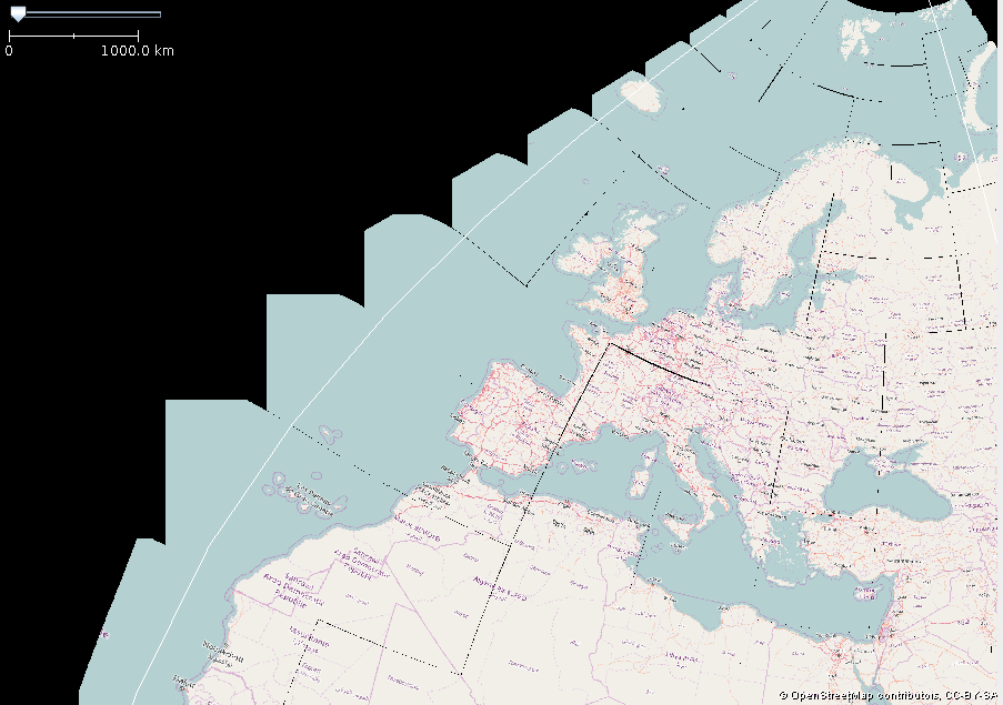
Another edition of fun with projections:

Mercator Carto tiles reprojected to UTM 35 + rotated 8 degrees. (Notice how on the standard Mercator map, the Kola peninsula is as big as Turkey? It isn't, really...)
comment:26 by , 9 years ago
In the imagery preferences, we have a setting Fade Color and Fade amount. Is this still a useful feature or is it obsoleted by per layer opacity setting? I'm asking because the current Fade implementation doesn't work with warped tiles and would need to be adapted a bit.
comment:27 by , 9 years ago
I'd drop it. Two options for the same feature are usually not that helpful at all.
follow-up: 30 comment:29 by , 9 years ago
We can also drop the 4326/3857 workaround when we have reprojection...
follow-ups: 32 33 comment:30 by , 9 years ago
comment:32 by , 9 years ago
comment:33 by , 9 years ago
comment:37 by , 9 years ago
We have 2 fairly elaborate algorithms to display tiles from other zoom levels when the current tile is still loading or has an error:
Tile.loadPlaceholderFromCacheAbstractTileSourceLayer.drawInViewArea(loop overotherZooms)
As far as I can tell, both do essentially the same thing. Is there a reason it is done this way?
(Btw., Tile.loadPlaceholderFromCache uses tile index arithmetic that probably doesn't work for general WMTS tile matrix set.)
comment:39 by , 9 years ago
In [o33206] - [jmapviewer] move TileRange? class to jmapviewer
In [o33207] - see #7427 - add interface and class for projected coordinates; add several helper functions to TileSource interface
follow-up: 45 comment:44 by , 9 years ago
Replying to bastiK:
In 11832/josm:
Are there no performance drawbacks (esp. with partially loaded imageries, or on places, where max zoom differs for example in Bing)?
loadPlaceholderFromCache only checks in tileCache (memory, with BufferedImages).
The other thing that drawInViewArea / paintTileImages does not do is to create tile images based on data from different zoom level.
comment:45 by , 9 years ago
Replying to wiktorn:
Replying to bastiK:
In 11832/josm:
Are there no performance drawbacks (esp. with partially loaded imageries, or on places, where max zoom differs for example in Bing)?
Can you explain in more detail? There are no significant performance drawbacks, that I'm aware of. What do you mean by max zoom differs?
loadPlaceholderFromCache only checks in tileCache (memory, with BufferedImages).
In drawInViewArea, below the line ts.loadAllTiles(false);, it does exactly the same, i.e. check tileCache for images of different zoom level (no new jobs submitted).
The other thing that
drawInViewArea/paintTileImagesdoes not do is to create tile images based on data from different zoom level.
The tiles from different zoom levels are drawn on the fly, which should be about as fast.
follow-up: 47 comment:46 by , 9 years ago
I'm worried about missing this logic
                /*
                 * use LazyTask for graphics to avoid evaluation of tmpImage, until we have
                 * something to draw
                 */
                CachedCallable<Graphics2D> graphics = new CachedCallable<>(new Callable<Graphics2D>() {
                    @Override
                    public Graphics2D call() throws Exception {
                        Graphics2D g = (Graphics2D) tmpImage.call().getGraphics();
                        g.setTransform(AffineTransform.getScaleInstance(scale, scale));
                        return g;
                    }
                });

                int paintedTileCount = 0;
                for (int x = 0; x < factor; x++) {
                    for (int y = 0; y < factor; y++) {
                        Tile tile = cache.getTile(source, xtileHigh + x, ytileHigh + y, zoomHigh);
                        if (tile != null && tile.isLoaded()) {
                            paintedTileCount++;
                            tile.paint(graphics.call(), x * source.getTileSize(), y * source.getTileSize());
                        }
                    }
                }
                if (paintedTileCount == factor * factor) {
                    image = tmpImage.call();
                    return;
                }
            }

            int zoomLow = zoom - zoomDiff;
            if (zoomLow >= JMapViewer.MIN_ZOOM) {
                int xtileLow = xtile >> zoomDiff;
                int ytileLow = ytile >> zoomDiff;
                final int factor = 1 << zoomDiff;
                final double scale = factor;
                CachedCallable<Graphics2D> graphics = new CachedCallable<>(new Callable<Graphics2D>() {
                    @Override
                    public Graphics2D call() throws Exception {
                        Graphics2D g = (Graphics2D) tmpImage.call().getGraphics();
                        AffineTransform at = new AffineTransform();
                        int translateX = (xtile % factor) * source.getTileSize();
                        int translateY = (ytile % factor) * source.getTileSize();
                        at.setTransform(scale, 0, 0, scale, -translateX, -translateY);
                        g.setTransform(at);
                        return g;
                    }

                });

                Tile tile = cache.getTile(source, xtileLow, ytileLow, zoomLow);
                if (tile != null && tile.isLoaded()) {
                    tile.paint(graphics.call(), 0, 0);
                    image = tmpImage.call();
                    return;
                }
            }
Check for example area like this:
https://www.openstreetmap.org/#map=19/53.969564628111144/21.554929044008773
Goto from zoom 19 to zoom 12 and compare both versions. This is the place, that I guess, that we are loading tiles from different zoom levels.
comment:47 by , 9 years ago
Replying to wiktorn:
I'm worried about missing this logic
[...]
From my understanding, the code in drawInViewArea / paintTileImages reproduces this logic (in a slightly different way but with same outcome).
Check for example area like this:
https://www.openstreetmap.org/#map=19/53.969564628111144/21.554929044008773
Goto from zoom 19 to zoom 12 and compare both versions. This is the place, that I guess, that we are loading tiles from different zoom levels.
I did, but don't know what to look out for. In both version, it shows the loaded tiles from level 19 in the center temporarily, then downloads and displays tiles from the current level.
comment:50 by , 9 years ago
| Cc: | removed |
|---|
by , 9 years ago
| Attachment: | reference.png added |
|---|
by , 9 years ago
| Attachment: | test-output.png added |
|---|
by , 9 years ago
| Attachment: | test-differences.png added |
|---|
comment:52 by , 9 years ago
For future reference, as result of [11835], the viewport in MapCSSRendererTest moved by about 0.3 pixel in both x and y:
previous: now:
now: difference:
follow-up: 54 comment:53 by , 9 years ago
wiktorn, if there is something wrong with [11832] I would appreciate your help to understand what is the problem (and fix it). Right now, I'm still convinced it is fine and will proceed.
comment:54 by , 9 years ago
Replying to bastiK:
wiktorn, if there is something wrong with [11832] I would appreciate your help to understand what is the problem (and fix it). Right now, I'm still convinced it is fine and will proceed.
Please continue. You've convinced me that this is ok. Happy to see that code gone away :-)
I'll take [11839] and give it some testing.
comment:56 by , 9 years ago
In [o33209] - [jmapviewer] see #7427 - adapt the Tile class a bit, so it can store reprojected tiles.
follow-up: 64 comment:61 by , 9 years ago
I was a bit reluctant to delete TMSCachedTileLoaderJob#getCachedTile(), as loading a tile from disk cache (without http request) seems like a useful functionality. But if it's not used, it has no place in the codebase, I guess.
Most API breaking changes should be done now.
comment:64 by , 9 years ago
Replying to bastiK:
I was a bit reluctant to delete TMSCachedTileLoaderJob#getCachedTile(), as loading a tile from disk cache (without http request) seems like a useful functionality. But if it's not used, it has no place in the codebase, I guess.
Most API breaking changes should be done now.
I guess this method is from time when I tried to remove TileCache and rely only on JCS Cache but I had to abandon this approach due to performance reasons.
comment:65 by , 9 years ago
In [o33211] - [jmapviewer] class TileAnchor not needed in jmapviewer -> move to JOSM
by , 9 years ago
| Attachment: | reprojection.patch added |
|---|
comment:68 by , 9 years ago
In [o33219] - [jmapviewer] see #7427 - remove 'final' + extend toString()
comment:72 by , 9 years ago
Replying to bastiK:
Please test and report any problems!
Can you please add Javadoc for ImageryLayer.getNativeProjections()? It's now missing for some plugins but I don't know if it's mandatory, optional, null-safe, etc.
comment:74 by , 9 years ago
15 tests are failing:
 org.openstreetmap.josm.data.imagery.WMTSTileSourceTest.testParserForMissingStyleIdentifier	0.82 s	1
 org.openstreetmap.josm.data.imagery.WMTSTileSourceTest.testWIEN	0.69 s	1
 org.openstreetmap.josm.data.imagery.WMTSTileSourceTest.testGeoportalORTOPL2180	0.73 s	1
 org.openstreetmap.josm.data.imagery.WMTSTileSourceTest.testGeoportalORTOPL4326	0.7 s	1
 org.openstreetmap.josm.data.imagery.WMTSTileSourceTest.testParserForDuplicateTags	0.72 s	1
 org.openstreetmap.josm.data.imagery.WMTSTileSourceTest.testGeoportalTOPOPL	0.67 s	1
 org.openstreetmap.josm.data.imagery.WMTSTileSourceTest.testTicket12168	0.82 s	1
 org.openstreetmap.josm.data.imagery.WMTSTileSourceTest.testPseudoMercator	0.63 s	1
 org.openstreetmap.josm.data.imagery.WMTSTileSourceTest.testWALLONIE	0.58 s	1
 org.openstreetmap.josm.gui.NavigatableComponentTest.testZoomToFactor	1.2 s	1
 org.openstreetmap.josm.gui.NavigatableComponentTest.testZoomToFactorCenter	1 s	1
 org.openstreetmap.josm.gui.mappaint.MapCSSRendererTest.testRender[node-shapes]	3.3 s	1
 org.openstreetmap.josm.gui.mappaint.MapCSSRendererTest.testRender[node-text]	0.71 s	1
 org.openstreetmap.josm.gui.mappaint.MapCSSRendererTest.testRender[area-icon]	0.39 s	1
 org.openstreetmap.josm.gui.mappaint.MapCSSRendererTest.testRender[order]	0.57 s	1
comment:85 by , 9 years ago
Replying to Don-vip:
OK. Did you look at jt-warp? It's licensed under Apache 2.0.
I had another look at this library and basically what they are doing, is to extend the JAI classes for nodata support. This is the main selling point of jai-ext: a magic pixel value or range, indicating there is no data for a region of an image. Not exactly something we need, but the code is still interesting:
- It shows how to make use of the internal image data structure for maximum efficiency. This gets a bit unwieldy, with several cases and code duplication, so not something one can easily copy & paste.
- It demonstrates some nice tricks and efficient data layout of the JAI library.
The new custom implementation ImageWarp does what it should, but in terms of runtime it is still pretty slow. Thanks to the caching, it doesn't have to be super efficient. But it may still be noticeably slow, especially for 512x512 tiles (test reports welcome).
The main reason for low efficiency is not pixel lookup and color interpolation, but coordinate conversion from one projection to another. Currently, this is done once for each pixel. An obvious optimization would be to take a grid with 10 px spacing, transform only every 10th pixel and interpolate in between (expected improvement: factor 100). In JAI, they have anticipated this problem, the class javax.media.jai.WarpGrid is precisely what would be needed here.
follow-up: 87 comment:86 by , 9 years ago
Can you check dropping "epsg4326to3857Supported" handling and using reprojection instead. That should mean that Mercator now looks good for lower zoom levels in case the WMS only supports EPSG:4326 (This is not the case with the workaround).
comment:87 by , 9 years ago
Replying to stoecker:
Can you check dropping "epsg4326to3857Supported" handling and using reprojection instead. That should mean that Mercator now looks good for lower zoom levels in case the WMS only supports EPSG:4326 (This is not the case with the workaround).
The 4326to3857 code should be gone already.
comment:94 by , 9 years ago
ImageWarp.java:61, URF_UNREAD_FIELD
UrF: Unread field: org.openstreetmap.josm.tools.ImageWarp$GridTransform.deletedRows

ImageWarp.java:110, DLS_DEAD_LOCAL_STORE
DLS: Dead store to del in org.openstreetmap.josm.tools.ImageWarp$GridTransform.cleanUp(int)
comment:95 by , 9 years ago
Not sure what to do about it - nothing wrong with the code, as far as I can tell. :)
comment:96 by , 9 years ago
Problem comes from private static final boolean CONSISTENCY_TEST = false;. Findbugs operate on bytecode, so it does not guess you want to sometimes set it to true for debugging purposes. Is it still needed?
comment:97 by , 9 years ago
Yes, it is fairly easy to misuse this class. The code would still run without error, but performance-wise it would have an adverse effect. The consistency test catches this and also documents the expected behavior.
Basically it is a poor man's unit test and only needs to be enabled for a bit whenever the related code changes. I can also activate the consistency test permanently - it shouldn't make much of a difference.
comment:98 by , 9 years ago
Why do not enabling this feature in debug or trace mode, rather than through a static boolean? Everyone could enable it without recompiling JOSM, and Findbugs would be happy.
by , 9 years ago
| Attachment: | DimmingTiles.png added |
|---|
follow-up: 103 comment:100 by , 9 years ago
| Resolution: | fixed |
|---|---|
| Status: | closed → reopened |
When dimming a tile layer (here bing) lines appear at the tile borders. They also appear sometimes even without dimming.
(Position: https://www.openstreetmap.org/#map=19/53.03892/14.10883)

comment:103 by , 9 years ago
Replying to Klumbumbus:
They also appear sometimes even without dimming.
addition: they are black in this case, i.e. there is a little gap between the tiles
comment:104 by , 9 years ago
I've noticed the same. This is especially visible with layers with monotone colours.
One of such examples is ISOK hillshade in Poland - mostly greyish.
follow-up: 108 comment:105 by , 9 years ago
@Klumbumbus: Thanks for reporting, this in not something I have seen so far. I wasn't able to reproduce. Could you start JOSM in debug mode and check again? There will be a thin red outline, but hopefully the seam is still visible underneath. I'm interested in the size of the boxes, i.e. is it 256x256 px or larger? Please add Tile info dialog from the right click menu if you make another screen shot.
@wiktorn: What is the server projection and what is the display projection?
follow-up: 109 comment:106 by , 9 years ago
Currently I can't really reproduce this. Lines appear when panning and zooming around when tiles from another zoomlevel are displayed. But in the end when all tiles are loded the lines are gone.
(However when doing the screenshot the lines were permanent.)
follow-up: 110 comment:107 by , 9 years ago
In my case: server projection is EPSG:2180 and display projection - Mercator.
And I've just run in the debug mode. The black lines are the same size as the tiles.
If I take Bing layer as a background and use display projection: EPSG:2180, then the lines are also visible (but far less than with ISOK hillshade at Mercator display projection).
comment:108 by , 9 years ago
Replying to bastiK:
There will be a thin red outline, but hopefully the seam is still visible underneath.
It seems the red lines hide the other lines
comment:109 by , 9 years ago
Replying to Klumbumbus:
Currently I can't really reproduce this. Lines appear when panning and zooming around when tiles from another zoomlevel are displayed. But in the end when all tiles are loded the lines are gone.
Confirmed, I'll have a look.
(However when doing the screenshot the lines were permanent.)
If reproducible, this should be investigated.
comment:110 by , 9 years ago
Replying to wiktorn:
In my case: server projection is EPSG:2180 and display projection - Mercator.
And I've just run in the debug mode. The black lines are the same size as the tiles.
If I take Bing layer as a background and use display projection: EPSG:2180, then the lines are also visible (but far less than with ISOK hillshade at Mercator display projection).
When displaying the imagery in the native projection, it should work just as before, i.e. no black lines between tiles.
However, when reprojecting the tiles one by one, I wasn't able to avoid the seams so far and basically considered it an acceptable imperfection. Please note that the pixel positions are still accurate, i.e. there is no "physical gap" that would break a diagonal straight line.
Maybe there is a simple fix to improve this "feature". It can certainly be avoided by requesting pixel data from the 4 adjacent tiles during warp operation. But this seems excessively complicated.
comment:111 by , 9 years ago
Sorry for the noise then. That was what I thought when I saw them for the first time. And I did not read Kulumbus comment carefully enough to notice that he was displaying tiles with no reprojection.
follow-up: 120 comment:118 by , 9 years ago
It seems to work fine :)
It would be interesting to have a unit test for ReprojectionTile, do you see how to write a meaningful one?
comment:120 by , 9 years ago
| Resolution: | → fixed |
|---|---|
| Status: | reopened → closed |
Replying to Don-vip:
It would be interesting to have a unit test for
ReprojectionTile, do you see how to write a meaningful one?
Difficult for this class, but would be good for some of the other new methods.
follow-up: 122 comment:121 by , 9 years ago
I'm impressed what already has been done in this ticket. Display of reprojection and also non reprojected tiles is really seemless. Lots of cases with slight distortion at the tile boundary are gone. That's excellent!
Nevertheless there is always a bit to improve. :-) I tried downloading Berlin WMS and while reprojected data is seemless there are small black stripes when you zoom in and out. It seems that the display code for the tiles of up-/downscaled zoom is not as perfect as the current zoom level...
comment:122 by , 9 years ago
Replying to stoecker:
Nevertheless there is always a bit to improve. :-) I tried downloading Berlin WMS and while reprojected data is seemless there are small black stripes when you zoom in and out. It seems that the display code for the tiles of up-/downscaled zoom is not as perfect as the current zoom level...
Yes I'm aware of this, the thing is that reprojected tiles simply don't fit together seamlessly when one comes from a different zoom level and is up- or downscaled. This happens to work well for standard tiles, because they are square shaped and the tile size in pixels is a power of 2. All this is no longer true for a reprojected tile - you may have noticed that it is often slightly rotated and the tile boundary may be curved. I do not have a good solution for this right now.
comment:123 by , 9 years ago
If you can't fix it, can't you cheat? A black pixel is very good visible. A pixel with the same colour as its neighbor hardly.
comment:124 by , 9 years ago
If you increase the transparency, you'll notice there are not only gaps but also overlapping parts. So for the cosmetic fix you'd need a pixel-precise mask of the tile in current zoom level, then scale the replacement tile, clip the excess parts and fill in the gaps by extrapolating with the pixel color at the mask outline.
This may be too slow for event dispatch thread, which makes it even more awkward to implement.
Pretty complicated overall, I think, I'll postpone to next month and see if an easier solution emerges.
comment:125 by , 5 years ago
| Keywords: | projection warping added |
|---|
This should be possible with the GeoTools library. It is currently implemented by the ImportImage (JOSM-)plugin. In the plugin, the JAI lib is used, as well. However, as far as I can tell, JAI licenses aren't GPL compatible. According to this thread, it seams, that JAI is not a hard dependency for image warping with GeoTools, but only needed for very large images.
In any case, this would need to go into a plugin as GeoTools is very bloated.