

#10087 closed enhancement (wontfix)
Display object centroid
| Reported by: | naoliv | Owned by: | team |
|---|---|---|---|
| Priority: | normal | Milestone: | |
| Component: | Core | Version: | latest |
| Keywords: | Cc: |
Description
Like JOSM already display a small + signal in the middle of ways, couldn't it also display the centroid (the same info that we get with Shift+i) of an object (area or polygon), please?
It would be great to use the center/centroid for object alignment or positioning.
Repository Root: http://josm.openstreetmap.de/svn
Build-Date: 2014-05-31 01:36:44
Last Changed Author: bastiK
Revision: 7193
Repository UUID: 0c6e7542-c601-0410-84e7-c038aed88b3b
URL: http://josm.openstreetmap.de/svn/trunk
Last Changed Date: 2014-05-30 10:27:18 +0200 (Fri, 30 May 2014)
Last Changed Rev: 7193

Identification: JOSM/1.5 (7193 pt_BR) Linux Debian GNU/Linux unstable (sid)
Memory Usage: 272 MB / 1756 MB (79 MB allocated, but free)
Java version: 1.7.0_55, Oracle Corporation, OpenJDK 64-Bit Server VM
Java package: openjdk-7-jre:amd64-7u55-2.4.7-2
VM arguments: [-Djava.net.useSystemProxies=true, -Dawt.useSystemAAFontSettings=on]
Dataset consistency test: No problems found

Plugin: AddrInterpolation (30416)
Plugin: Create_grid_of_ways (30416)
Plugin: FixAddresses (30416)
Plugin: ImageryCache (30416)
Plugin: OpeningHoursEditor (30416)
Plugin: PicLayer (30436)
Plugin: SimplifyArea (30416)
Plugin: buildings_tools (30416)
Plugin: editgpx (30416)
Plugin: geochat (30416)
Plugin: geotools (30416)
Plugin: jts (30416)
Plugin: merge-overlap (30416)
Plugin: notes (v0.9.2)
Plugin: opendata (30436)
Plugin: pdfimport (30416)
Plugin: poly (30416)
Plugin: reverter (30436)
Plugin: tagging-preset-tester (30416)
Plugin: todo (29154)
Plugin: turnrestrictions (30454)
Plugin: undelete (30416)
Plugin: utilsplugin2 (30460)
Attachments (3)
Change History (12)
comment:1 by , 12 years ago
by , 12 years ago
| Attachment: | centroid.png added |
|---|
by , 12 years ago
| Attachment: | real-life.png added |
|---|
by , 12 years ago
| Attachment: | centroid-symbol.png added |
|---|
comment:2 by , 12 years ago
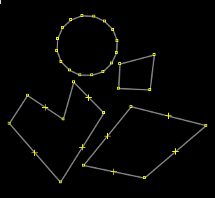
It's not for the ways, but for the areas.
See this example:

How do we know where is the center/centroid of those objetcs? It's possible to trace some straight lines and roughly calculate them, but it's not an easy or fast process. It also won't give us a precise result.
It's possible to see their centroids with Ctrl+i and add a node to this position. But if you move the object, resizes or modify it, you need to see this info again (and move the node again).
It's what I did (with a lot of work) to align the objects of this stadium:

JOSM could display something like this, but using an apropriated symbol and/or color (instead the node that I had moved to their centroid):

comment:3 by , 12 years ago
I know what the centroid is. My question was what displaying and handling it would allow, which is not yet possible when handling the way.
comment:4 by , 12 years ago
Mainly to align and place/position objects, regardless their shapes (like I had to do with the stadium).
comment:5 by , 12 years ago
| Resolution: | → wontfix |
|---|---|
| Status: | new → closed |
I think that is a very specific requirement, which does not verify cluttering the display any more with hard to understand data (try understanding as novice what these symbols are for larger or overlapping areas.
follow-up: 8 comment:6 by , 12 years ago
I understand, but it could be an option (disabled by default) to have this symbol displayed or not.
comment:7 by , 12 years ago
Another example: I have some runway lengths, widths and the latitude/longitude of their center.
Having this kind of information displayed would allow me to create a node at this location and then align the runway center to the correct location, without needing to trace more auxiliary lines.
comment:8 by , 12 years ago
Replying to naoliv:
I understand, but it could be an option (disabled by default) to have this symbol displayed or not.
Well displaying is not such an issue. Very likely this can be solved by a specific style (maybe needing with the help of some mapcss changes). But using it for operations is a bigger task. We don't even do that for the icons of turn-restrictions, which are displayed for a long time now.
What would that allow, which you can't do when clicking on a way?