

| Version 4 (modified by , 15 years ago) ( diff ) |
|---|
This style visualizes the surface=* and smoothness tags on highways. Currently it does the following:
- show highways that neither have surface=* or smoothness=* as solid black
- with the smoothness tag render a
- blue thin line for smoothness=excellent
- move from green (=good) to red (=impassable) for the rest of smoothness values, at the same time thicken the way and use dashed stiles as smoothness values
- with the surface tag render a
- soft white halo (but only for values paved|asphalt|concrete|concrete_pavers)
- for the rest render the value with text (light brown for dirt, ground, mud, light green for grass, etc..)
- do not render text for the most common values (excellent, good, asphalt, paved) as they are easily identifyable by color code and would distract from the problem zones
meta
{
    title: "Surface";
    description: "Visualize surface=* of objects";
    version: "25_2019-07-18";
    author: "cmuelle8";

    watch-modified: true;
}

meta[lang=de]
{
    title: "Oberflächenbeschaffenheit";
    description: "Oberflächenbeschaffenheit, etwa von Wegen, hervorheben";
}

canvas
{
    background-color: #606060;
}


node
{
    symbol-shape: square;
    symbol-size: 2;
    symbol-stroke-color: white;
    symbol-stroke-opacity: 0.1;
}

node:connection
{
    symbol-shape: square;
    symbol-size: 2;
    symbol-stroke-color: white;
    symbol-stroke-opacity: 0.1;
}

way
{
    width: 1;
    color: #FF0000;
    opacity: 0.0;
}

way[landuse]:closed
{
    fill-color: yellow;
    fill-opacity: 0.02;
    z-index: -0.9;
}

way[natural]:closed
{
    fill-color: green;
    fill-opacity: 0.02;
    z-index: -0.9;
}

way[building]:closed
{
    width: 2;
    color: magenta;
    opacity: 0.1;
    fill-color: magenta;
    fill-opacity: 0.02;
    z-index: -0.8;
}

way[highway][area?]:closed
{
    width: 2;
    color: orange;
    opacity: 0.5;
    fill-color: orange;
    fill-opacity: 0.2;
    z-index: -0.5;
}

way[highway][!area]
{
    color: #202020;
    opacity: 1.0;
    z-index: 1.0;
}


way[highway][smoothness=impassable]
{
    width: 4;
    color: eval(rgb((7*0.142*(1-red(prop(color)))) + red(prop(color)), (1*0.142*(1-green(prop(color)))) + green(prop(color)), blue(prop(color))));
    dashes: list(3,5,2,2,5,3);
}

way[highway][smoothness=very_horrible]
{
    width: 4;
    color: eval(rgb((6*0.142*(1-red(prop(color)))) + red(prop(color)), (2*0.142*(1-green(prop(color)))) + green(prop(color)), blue(prop(color))));
    dashes: list(3,5,2,2,5,3);
}

way[highway][smoothness=horrible]
{
    width: 4;
    color: eval(rgb((5*0.142*(1-red(prop(color)))) + red(prop(color)), (3*0.142*(1-green(prop(color)))) + green(prop(color)), blue(prop(color))));
    dashes: list(3,5,2,2,5,3);
}

way[highway][smoothness=very_bad]
{
    width: 3;
    color: eval(rgb((4*0.142*(1-red(prop(color)))) + red(prop(color)), (4*0.142*(1-green(prop(color)))) + green(prop(color)), blue(prop(color))));
    dashes: list(3,5,2,2);
}

way[highway][smoothness=bad]
{
    width: 3;
    color: eval(rgb((3*0.142*(1-red(prop(color)))) + red(prop(color)), (5*0.142*(1-green(prop(color)))) + green(prop(color)), blue(prop(color))));
    dashes: list(4,4,2,2);
}

way[highway][smoothness=intermediate]
{
    width: 2;
    color: eval(rgb((2*0.142*(1-red(prop(color)))) + red(prop(color)), (6*0.142*(1-green(prop(color)))) + green(prop(color)), blue(prop(color))));
    dashes: list(7,5);
}

way[highway][smoothness=good]
{
    color: eval(rgb((1*0.142*(1-red(prop(color)))) + red(prop(color)), (7*0.142*(1-green(prop(color)))) + green(prop(color)), 0.4));
    dashes: list(10,2);
}

way[highway][smoothness=excellent]
{
    color: eval(rgb(red(prop(color)), green(prop(color)), 1.0));
}


way[highway][surface],
way[highway][smoothness]
{
    print-text: true;
    text-color: #B0E0EE;
    text-offset: 4;
}

way[highway][surface=unpaved],
way[highway][surface=dirt],
way[highway][surface=ground],
way[highway][surface=mud]
{
    text-color: #FFB0B0;
}

way[highway][surface=grass]
{
    text-color: #B0FFB0;
}

way[highway][surface=gravel],
way[highway][surface=fine_gravel],
way[highway][surface=pebblestone]
{
    text-color: #FFFFB0;
}

way[highway][surface=paved],
way[highway][surface=asphalt],
way[highway][surface=concrete],
way[highway][surface=concrete_pavers]
{
    print-text: false;
    casing-width: +2;
    casing-color: #7777AA;
    casing-dashes: eval(prop(dashes));
}

way[highway][smoothness=excellent],
way[highway][smoothness=good]
{
    print-text: false;
}

way[highway][smoothness][eval(prop(print-text))]
{
    font-size: 10;
    text: "smoothness";
    text-color: #EEE9BF;
    text-position: line;
    z-index: 1.0;
}

way[highway][surface][eval(prop(print-text))]
{
    font-size: 10;
    font-family: Arial;
    text: "surface";
    text-position: line;
    z-index: 1.0;
}
Styles_Surface-style.mapcss, Styles_Surface.zip
If you need more styles, or have more professional needs,
give me a holler via http://www.openstreetmap.org/message/new/cmuelle8
sample screenshot:
 screenshot")
Attachments (3)
-
josm-surface-smoothness-mappaint-style.png
(412.4 KB
) - added by 15 years ago.
(NOZIP) screenshot
-
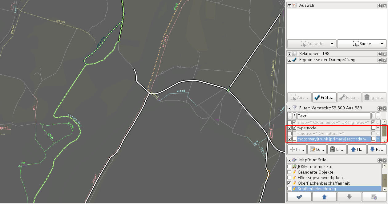
styles-surface-mapcss-lowzoom_howto_filter.png
(303.7 KB
) - added by 15 years ago.
(NOZIP) how to use josm filter to gain a better view
-
styles-surface-mapcss-highzoom.png
(217.3 KB
) - added by 15 years ago.
(NOZIP) highzoom screenshot of style
Download all attachments as: .zip
Note:
See TracWiki
for help on using the wiki.