| Version 1 (modified by , 11 years ago) ( diff ) |
|---|
under construction
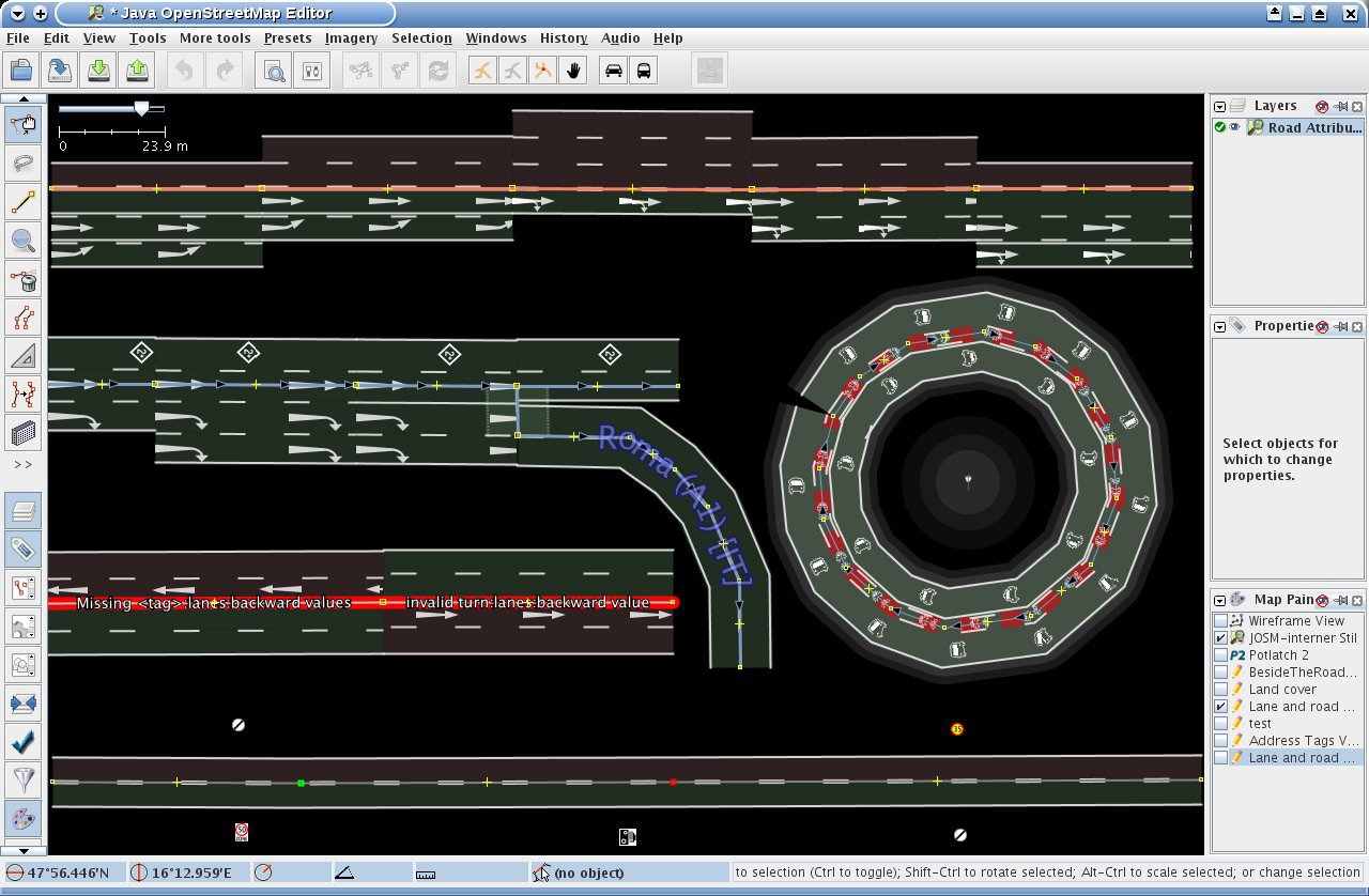
Fahrspur- und Straßenattribute MapPaint-Stil
Dieser Stil visualisiert eine Reihe von Fahrspur- und Straßenspezifischen Eigenschaften. Das heißt es werden die gängigen Varianten der folgenden tags berücksichtigt:
- lanes: Spurenanzahl für motorisierten Verkehr.
- width: Die Breite der Fahrbahn. Fahrspurspezifische Breite mittels width:lanes wird vollständig unterstützt.
- change: Erlaubte bzw. verbotene Spurwechsel.
- turn: Anzeige von Abbiegespuren, inklusive vorläufiger Unterstützung der Werte hook_right und hook_left (dies wird sich evtl. ändern!)
- cycleway: Radwege werden nur unterstützt, wenn sie mit cycleway angegeben sind. Radspuren erfordern bicycle:lanes=...|designated|... um angezeigt zu werden.
- bicycle:lanes: Radspuren.
- bus:lanes: Busspuren.
- psv:lanes: Spuren für öffentliche Verkehrsmittel (public service vehicle).
- placement: Platzierung der Straße relativ zum OSM-Weg. Der Wert transition wird nicht unterstützt.
- man_made=bridge: Wird benutzt, um den Umriss einer Brücke anzuzeigen und alle Eigenschaften dieser Brücke zu gruppieren.
- lit: Anzeige, ob eine Straße beleuchtet ist oder nicht.
- highway=street_lamp: Straßenlampen
- destination: Signposted destination of a road. Only rudimentary support without lane-dependent values. The subkeys destination:ref and destination:country are also supported.
- highway=junction: Can be used to indicate the outline of a junction and group together all features of it.
- Relation enforcement: The to and from members of such relations are highlighted
- traffic_sign: Traffic signs for speed limits and overtaking are displayed if tagged with traffic_sign=maxspeed/overtaking and maxspeed=<limit> resp. overtaking=yes/no. The value implicit for maxspeed is interpreted as the end of the speed limit. Combinations like traffic_sign=maxspeed;overtaking are also supported.
- hov:lanes: Dedicated HOV lanes. The minimum requirement can be specified by hov:minimum (supported values: 2 and 3)
- Relation destination_sign: Experimental and very limited support!
- driving_side: Used to specify the driving side of the traffic. This is only supported on ways.
Furthermore:
- Common suffixes like :forward, :backward, :left, :right: and :both as well as the proposed :both_ways (for lanes in both directions) are supported where appropriate.
- Some common tagging errors are detected and displayed, e.g. inconsistent number of lane-dependent values and typos in the keys turn and change.
- The style also supports left-hand traffic; see section Settings.
Use the Map Style Dialog to download and activate the style. A good starting point to see it in action is the area around Graz in Austria.
To report bugs or provide feedback send me a message.
Settings
Some settings of the style can be configured using Edit -> Preferences -> Display settings -> Colours. All settings start with mappaint.lane.and.road.attributes. Settings that contain the text "boolean" treat white as yes and any other color as no. Settings that contain the text "opacity" use the lightness to specify the opacity (the values for transparency or alpha are completely ignored!)
- The settings carriage.way.backward, carriage.way.forward, carriage.way.both_ways specify the colour of the respective lanes.
- The settings sidewalk, cycletrack and combined.sidewalk.and.cycletrack specify the colour of the sidewalk, a cycletrack and a combined sidewalk and cycletrack
- If boolean.right.hand.traffic is set to white, lanes are rendered for right hand traffic, otherwise for left hand traffic.
- If boolean.use.svg is set to white, the markings for turning lanes are rendered more precisely. If you run into memory problems, set this to black.
- The settings opacity.lane, opacity.markings and opacity.sidewalk specify the opacity of the lane background, road markings and the sidewalk background. If set to white they are opaque; if set to black they are completely transparent, any grey setting in between is treated an appropriate opacity.
Known limitations/bugs
- A bug in JOSM leads sometimes to rendering artefacts.
- Left-hand traffic is nearly untested. Please provide feedback.
- Roads with oneway=-1 may lead to incorrect results. Please provide feedback.
- change:lanes without suffix is currently only supported on one-ways and for the special case of change:lanes=no|no.
- In forward and backward direction a maximum of eight lanes and for lanes in both directions a maximum of four lanes is displayed.
Acknowledgments
- To Wolfgang Hinsch who created a first style which visualizes many lane-specific features. Before I saw his style I wouldn't believe that this is possible.
- To Paul Hartmann who implemented some desperately needed extensions for JOSM which made the implementation of this style a lot easier and improved performance significantly.
- To all who provided valuable feedback during the creation of this style.
Preset
An appropriate preset for lane attributes is available at Lane Attributes.
Screenshot
Quellcode
Siehe englische Seite.


