

#20875 closed defect (fixed)
Sync window displaying invalid timestamp with sub-second values
| Reported by: | AlaskaDave | Owned by: | simon04 |
|---|---|---|---|
| Priority: | normal | Milestone: | 21.05 |
| Component: | Core image mapping | Version: | tested |
| Keywords: | template_report regression | Cc: | simon04 |
Description
What steps will reproduce the problem?
- Import some images into JOSM
- Right-click on the Geotagged Images layer and select "Correlate to GPS"
- Click on "Use Photo of an accurate clock ... "
- Select an image of your GPS time display
- After Step 4, two date/time text-boxes appear
- Both include weird characters that should not be there. You can enter the "EXIF time" in the lower box to provide the correction thus removing the extraneous characters but in the top box the reference date/time extracted from the image cannot be altered, that is, it will continue to have those extra characters. Therefore, any data you enter will be rejected as invalid.
I suspected the plugin but I couldn't find an earlier version of the plugin so I reinstalled JOSM version 17702 and the problem went away.
URL:https://josm.openstreetmap.de/svn/trunk
Repository:UUID: 0c6e7542-c601-0410-84e7-c038aed88b3b
Last:Changed Date: 2021-04-01 23:17:01 +0200 (Thu, 01 Apr 2021)
Build-Date:2021-04-01 21:46:03
Revision:17702
Relative:URL: ^/trunk

Identification: JOSM/1.5 (17702 en) Windows 10 64-Bit
OS Build number: Windows 10 Pro 2009 (19042)
Memory Usage: 1685 MB / 1820 MB (871 MB allocated, but free)
Java version: 1.8.0_281-b09, Oracle Corporation, Java HotSpot(TM) 64-Bit Server VM
Look and Feel: com.sun.java.swing.plaf.windows.WindowsLookAndFeel
Screen: \Display0 1920×1080 (scaling 1.00×1.00)
Maximum Screen Size: 1920×1080
Best cursor sizes: 16×16→32×32, 32×32→32×32
System property file.encoding: Cp1252
System property sun.jnu.encoding: Cp1252
Dataset consistency test: No problems found

Plugins:
+ ColorPlugin (1537115529)
+ DirectDownload (35640)
+ DirectUpload (35640)
+ FastDraw (35640)
+ ImproveWay (29)
+ Mapillary (1.5.37.6)
+ OpeningHoursEditor (35640)
+ SimplifyArea (35640)
+ apache-commons (35524)
+ apache-http (35589)
+ buildings_tools (35740)
+ changeset-viewer (25)
+ editgpx (35562)
+ ejml (35458)
+ geotools (35458)
+ imagery_offset_db (35640)
+ javafx-windows (35655)
+ jaxb (35543)
+ jna (35662)
+ jts (35458)
+ measurement (35640)
+ opendata (35640)
+ photo_geotagging (35738)
+ rasterfilters (35648)
+ reltoolbox (35640)
+ tageditor (35640)
+ todo (30306)
+ turnlanes (35640)
+ turnlanes-tagging (288)
+ turnrestrictions (35640)
+ utilsplugin2 (35691)
+ waydownloader (35640)
+ wikipedia (1.1.4)

Tagging presets:
+ https://josm.openstreetmap.de/josmfile?page=Presets/BuildingPreset&zip=1
+ %UserProfile%\Dropbox (Personal)\GPS Files\Daves-Misc.xml
+ %UserProfile%\Dropbox (Personal)\GPS Files\Ponds.xml
+ %UserProfile%\Dropbox (Personal)\GPS Files\ResHwy.xml
+ %UserProfile%\Dropbox (Personal)\GPS Files\CoinOp_Fuel.xml
+ %UserProfile%\Dropbox (Personal)\GPS Files\Land-Natural.xml
+ %UserProfile%\Dropbox (Personal)\GPS Files\Wat.xml
+ %UserProfile%\Dropbox (Personal)\GPS Files\Stream.xml
+ %UserProfile%\Dropbox (Personal)\GPS Files\Service.xml
+ %UserProfile%\Dropbox (Personal)\GPS Files\TAP Service.xml
+ %UserProfile%\Dropbox (Personal)\GPS Files\Waters.xml
+ %UserProfile%\Dropbox (Personal)\GPS Files\BorC.xml
+ %UserProfile%\Dropbox (Personal)\GPS Files\Hamlet.xml
+ %UserProfile%\Dropbox (Personal)\GPS Files\address.xml
+ %UserProfile%\Dropbox (Personal)\GPS Files\UnclassHwy.xml
+ %UserProfile%\Dropbox (Personal)\GPS Files\ResArea.xml
+ %UserProfile%\Dropbox (Personal)\GPS Files\Benchmark.xml
+ %UserProfile%\Dropbox (Personal)\GPS Files\Bbl_Fuel.xml
+ %UserProfile%\Dropbox (Personal)\GPS Files\Milemarker.xml
+ %UserProfile%\Dropbox (Personal)\GPS Files\US_Fuel.xml
+ %UserProfile%\Dropbox (Personal)\GPS Files\NWR.xml
+ %UserProfile%\Dropbox (Personal)\GPS Files\DJS-Ways.xml
+ https://code.osm-tools.org/latest/josm-thai-presets.zip
+ %UserProfile%\Dropbox (Personal)\GPS Files\wlan.xml

Map paint styles:
- https://downloads.osm-tools.org/FB_edits.mapcss
- https://josm.openstreetmap.de/josmfile?page=Styles/PublicTransport&zip=1
- https://josm.openstreetmap.de/josmfile?page=Styles/Maxspeed&zip=1
+ https://josm.openstreetmap.de/josmfile?page=Styles/Whitewater&zip=1
- https://josm.openstreetmap.de/josmfile?page=Styles/Enhanced_Lane_and_Road_Attributes&zip=1

Last errors/warnings:
- 03565.545 W: Unable to convert property casing-color to type class java.awt.Color: found #66066 of type class java.lang.String!
- 03565.547 W: Unable to convert property casing-color to type class java.awt.Color: found #66066 of type class java.lang.String!
- 03565.719 W: Unable to convert property casing-color to type class java.awt.Color: found #66066 of type class java.lang.String!
- 03566.395 W: Unable to convert property casing-color to type class java.awt.Color: found #66066 of type class java.lang.String!
- 03566.395 W: Unable to convert property casing-color to type class java.awt.Color: found #66066 of type class java.lang.String!
- 03843.250 W: Unable to convert property casing-color to type class java.awt.Color: found #66066 of type class java.lang.String!
- 03843.252 W: Unable to convert property casing-color to type class java.awt.Color: found #66066 of type class java.lang.String!
- 03843.456 W: Unable to convert property casing-color to type class java.awt.Color: found #66066 of type class java.lang.String!
- 03844.162 W: Unable to convert property casing-color to type class java.awt.Color: found #66066 of type class java.lang.String!
- 03844.163 W: Unable to convert property casing-color to type class java.awt.Color: found #66066 of type class java.lang.String!
Attachments (4)
Change History (17)
comment:1 by , 5 years ago
| Component: | Core → Core image mapping |
|---|
by , 5 years ago
| Attachment: | 20875-syncdialog.png added |
|---|
comment:2 by , 5 years ago
Perhaps you're correct. I will reinstall the latest JOSM later and try again later. If I see the same problem, I'll make a screenshot and send it to you.
Thanks.
comment:3 by , 5 years ago
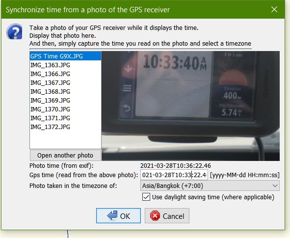
These photos were shot in Thailand last month. I reinstalled JOSM v17833 and have set the plugin to the proper timezone and the extraneous characters are shown in the screenshot [1]. Currently, I am in the U.S. in Pacific Daylight Time and my computer is set to that timezone as well
https://www.dropbox.com/s/ry1mbd0e5nt3l13/Geotagging%20screenshot.JPG?dl=0[]

comment:4 by , 5 years ago
| Cc: | added |
|---|---|
| Keywords: | regression added |
| Summary: | When using the Photo Geotagging plugin (ver. 35738) with JOSM ver 17833, extraneous characters appear in the synch window → Sync window displaying invalid timestamp with sub-second values |
Oh, now I get what you meant with the weird characters.
Could you also please upload the original JPG file (with EXIF data)? Thanks!
Also, what do you see when you go to Win 10 Settings > Time & Language > Region?
Does anything look different from this:

@simon04, this might be an issue with #14176 since apparently it did not occur in r17702 but r17833. But so far I couldn't reproduce it in either version, so I'll debug further once I have the original file.
by , 5 years ago
| Attachment: | 20875-settings.png added |
|---|
follow-up: 6 comment:5 by , 5 years ago
My Region page in Win10 looks exactly like yours except that I use the ISO date format, e.g., 2021-05-18. I don't change the Region settings when I'm in Thailand, which is where these images were taken.
I commute between the U.S. and Thailand twice per year but I never change the timezone in my camera, only the time. I sometimes have difficulty correlating the images after I arrive in either country but I never had weird characters in the text boxes before. In those situations, I will try the plugin with Auto-guess and that works sometimes but not always.
I supplied the photo I used for correlating the track points as an attachment to this thread.
Thanks for your help
by , 5 years ago
| Attachment: | Geotagging screenshot.JPG added |
|---|
comment:6 by , 5 years ago
| Milestone: | → 21.05 |
|---|
Replying to Dave Swarthout - AlaskaDave <daveswarthout@…>:
I supplied the photo I used for correlating the track points as an attachment to this thread.
Thank you!
Replying to Dave Swarthout - AlaskaDave <daveswarthout@…>:
My Region page in Win10 looks exactly like yours except that I use the ISO date format, e.g., 2021-05-18. I don't change the Region settings when I'm in Thailand, which is where these images were taken.
I finally figured out what's going on, the issue is the "Display > Display ISO dates" setting (Einstein iso.dates). For now if you disable that, everything should work as expected.
That was however already fixed by simon04 in r17840, so everything should work in the next stable.
@Simon, I still don't really like that org.openstreetmap.josm.tools.date.DateUtils.getDateTimeFormatter(FormatStyle, FormatStyle) behaves different than org.openstreetmap.josm.tools.date.DateUtils.getDateTimeFormat(int, int) (one has a sub-second value, one doesn't). What do you think about that?
I would actually suggest deprecating getDateTimeFormat entirely. I just played around with it a little, I can provide a patch for that if you want.
follow-up: 8 comment:7 by , 5 years ago
So the "weird character" is the "T" separating date and time? I've removed the "T" in r17840.
I don't mind removing the sub-seconds and, thus, providing compatibility with the old Date related function.
Some plugins use the old Date related functions. I would refrain from deprecating the functions unless someone steps up and fixes those deprecations in a timely manner
CommandLine/src/org/openstreetmap/josm/plugins/commandline/OsmToCmd.java
dataimport/src/org/openstreetmap/josm/plugins/dataimport/io/TangoGPS.java
imagery_offset_db/src/org/openstreetmap/josm/plugins/imagery_offset_db/OffsetDialogButton.java
imagery_offset_db/src/org/openstreetmap/josm/plugins/imagery_offset_db/OffsetInfoAction.java
infomode/src/org/openstreetmap/josm/plugins/infomode/InfoPanel.java
Mapillary/src/main/java/org/openstreetmap/josm/plugins/mapillary/utils/LocalDateConverter.java
NanoLog/src/nanolog/Correlator.java
opendata/src/org/openstreetmap/josm/plugins/opendata/core/io/geographic/KmlReader.java
comment:8 by , 5 years ago
Replying to simon04:
So the "weird character" is the "T" separating date and time? I've removed the "T" in r17840.
Yeah I know, see above.
I don't mind removing the sub-seconds and, thus, providing compatibility with the old
Daterelated function.
Some plugins use the old
Daterelated functions. I would refrain from deprecating the functions unless someone steps up and fixes those deprecations in a timely manner
CommandLine/src/org/openstreetmap/josm/plugins/commandline/OsmToCmd.java
dataimport/src/org/openstreetmap/josm/plugins/dataimport/io/TangoGPS.java
imagery_offset_db/src/org/openstreetmap/josm/plugins/imagery_offset_db/OffsetDialogButton.java
imagery_offset_db/src/org/openstreetmap/josm/plugins/imagery_offset_db/OffsetInfoAction.java
infomode/src/org/openstreetmap/josm/plugins/infomode/InfoPanel.java
Mapillary/src/main/java/org/openstreetmap/josm/plugins/mapillary/utils/LocalDateConverter.java
NanoLog/src/nanolog/Correlator.java
opendata/src/org/openstreetmap/josm/plugins/opendata/core/io/geographic/KmlReader.java
Isn't the whole point of deprecating functions instead of removing them to basically give plugin maintainers a hint to change them whenever they get a chance (and update anyways)? That's at least how I always viewed it.
But actually I think it's not really important, because DateFormat itself isn't deprecated (yet). So if you just remove the sub-seconds that's totally fine with me :)
comment:9 by , 5 years ago
So, are you saying that until the next release is published, I have to change my date format?
comment:10 by , 5 years ago
You just have to disable the checkbox within JOSM under "Settings > Display > Display ISO Dates".
Or you could use the latest version. That still displays milliseconds but at least applying the offset will work again.
comment:11 by , 5 years ago
| Owner: | changed from to |
|---|---|
| Status: | new → assigned |
Could you please provide
This is how the dialog looks for me:

My guess is that this is either caused by an uncommon locale (the date/time format may be different) or some corrupted EXIF data in your images.