

Opened 6 years ago
Last modified 6 years ago
#19995 closed defect
exit saving two layers (without upload) not possible — at Version 1
| Reported by: | leni | Owned by: | team |
|---|---|---|---|
| Priority: | normal | Milestone: | 20.11 |
| Component: | Core | Version: | |
| Keywords: | template_report upload save | Cc: | DevCharly, simon04 |
Description (last modified by )
What steps will reproduce the problem?
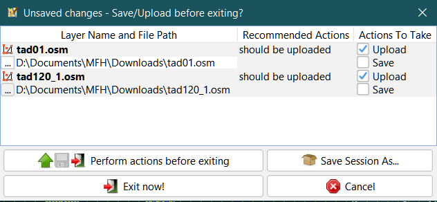
- I have two layers, with data modified.
- I leave josm ctrl+Q
- josm proposes to upload the two layers:

- I don't want to upload, I want to save; I remove upload from the 1st layer:

- I click on save on the 1st layer
What is the expected result?
save the 1st layer selected
What happens instead?
josm adds send and save:

I do not select only save
Please provide any additional information below. Attach a screenshot if possible.
URL:https://josm.openstreetmap.de/svn/trunk
Repository:UUID: 0c6e7542-c601-0410-84e7-c038aed88b3b
Last:Changed Date: 2020-10-03 13:42:38 +0200 (Sat, 03 Oct 2020)
Build-Date:2020-10-04 01:30:47
Revision:17084
Relative:URL: ^/trunk

Identification: JOSM/1.5 (17084 en_GB) Windows 10 64-Bit
OS Build number: Windows 10 Home 1909 (18363)
Memory Usage: 729 MB / 1751 MB (118 MB allocated, but free)
Java version: 1.8.0_261-b12, Oracle Corporation, Java HotSpot(TM) 64-Bit Server VM
Look and Feel: com.formdev.flatlaf.FlatLightLaf
Screen: \Display0 1920x1080 (scaling 1.0x1.0)
Maximum Screen Size: 1920x1080
Best cursor sizes: 16x16 -> 32x32, 32x32 -> 32x32
Dataset consistency test: No problems found

Plugins:
+ FastDraw (35499)
+ apache-commons (35524)
+ apache-http (35092)
+ buildings_tools (35563)
+ cadastre-fr (35539)
+ changeset-viewer (22)
+ conflation (0.6.6)
+ ejml (35313)
+ flatlaf (35541)
+ geotools (35169)
+ imagery_offset_db (35405)
+ javafx-windows (35458)
+ jaxb (35092)
+ jna (35092)
+ jts (35122)
+ measurement (35405)
+ opendata (35513)
+ photo_geotagging (35499)
+ photoadjust (35405)
+ reverter (35556)
+ scripting (30798)
+ shrinkwrap (v1.0.3)
+ tageditor (35258)
+ todo (30306)
+ utilsplugin2 (35487)
+ wikipedia (1.1.4)

Tagging presets:
+ https://josm.openstreetmap.de/josmfile?page=Presets/ParkingLanes&zip=1

Map paint styles:
- https://josm.openstreetmap.de/josmfile?page=Styles/Lane_features&zip=1
- https://josm.openstreetmap.de/josmfile?page=Styles/Lane_features_ryg&zip=1
- https://josm.openstreetmap.de/josmfile?page=Styles/Maxspeed&zip=1
+ https://josm.openstreetmap.de/josmfile?page=Styles/PTStops&zip=1
+ https://josm.openstreetmap.de/josmfile?page=Styles/PublicTransport&zip=1
- https://josm.openstreetmap.de/josmfile?page=Styles/ParkingLanes&zip=1
+ https://josm.openstreetmap.de/josmfile?page=Styles/Coloured_buildings&zip=1

Validator rules:
+ https://raw.githubusercontent.com/nlehuby/transport_mapcss/master/transport.validator.mapcss

Last errors/warnings:
- 00010.840 W: Warning: Failed to scan file 'fr.toulouse.jar' for module information. Skipping.
Change History (5)
by , 6 years ago
| Attachment: | josm2layers01.png added |
|---|
by , 6 years ago
| Attachment: | josm2layers02.png added |
|---|
by , 6 years ago
| Attachment: | josm2layers03.png added |
|---|
comment:1 by , 6 years ago
| Description: | modified (diff) |
|---|---|
| Keywords: | upload save added |
by , 6 years ago
| Attachment: | 19995_worksforme.png added |
|---|
Note:
See TracTickets
for help on using tickets.