

#17829 closed enhancement (fixed)
RTKLib Positioning Solution File (.pos) import
| Reported by: | StephaneP | Owned by: | Don-vip |
|---|---|---|---|
| Priority: | normal | Milestone: | 19.08 |
| Component: | Core | Version: | |
| Keywords: | RTKlib, Positioning Solution File, pos, sotmfr2019 | Cc: |
Description (last modified by )
Hi!
.pos file is the standard output file from the various RTKlib tools (FOSS). It's like a nmea or a gpx file with more informations inside, like Fix mode, deviation, ratio, ...
At this time, If I want to see the trace on an aerial imagery, I have to convert .pos to gpx to open it in Josm, and I lose many useful informations in the process.
Loading the pos files directly in Josm would be a great feature.
Attached with this ticket you will find a small pos file and the gpx (converted with the pos2kml tool).
There is some informations on Positioning Solution File in the documentation (page 101)
- Header lines
% program   : RTKLIB ver.demo5 b31
% inp file  : rover_2019-06-08_08-03-52.obs
% inp file  : 2019-06-08-00_00_00-GNSS-1.obs
% inp file  : 2019-06-08-00_00_00-GNSS-1.nav
% inp file  : 2019-06-08-00_00_00-GNSS-1.sbs
% obs start : 2019/06/08 08:03:55.5 GPST (week2056 547435.5s)
% obs end   : 2019/06/08 09:46:21.0 GPST (week2056 553581.0s)
% pos mode  : kinematic
% freqs     : L1
% solution  : combined
% elev mask : 15.0 deg
% dynamics  : on
% tidecorr  : off
% ionos opt : sbas
% tropo opt : sbas
% ephemeris : broadcast
% navi sys  : gps galileo beidou sbas
% amb res   : fix and hold
% val thres : 3.0
% antenna1  :                       ( 0.0000  0.0000  0.0000)
% antenna2  :                       ( 0.0000  0.0000  0.0000)
% ref pos   : 47.060027749  -1.350495019   84.8600
%
% (lat/lon/height=WGS84/ellipsoidal,Q=1:fix,2:float,3:sbas,4:dgps,5:single,6:ppp,ns=# of satellites)
%  GPST                  latitude(deg) longitude(deg)  height(m)   Q  ns   sdn(m)   sde(m)   sdu(m)  sdne(m)  sdeu(m)  sdun(m) age(s)  ratio
These lines could be in the layer info (except the last one)
If it exists, the "ref pos" could be a marker (it's the base station coordinates)
- Solution body
- Line ending is CR+LF
- The fields separator is 1 or more spaces.
- Fields names are on the last header line
- Fields conversion
- Time (GPST, UTC, ...) -> conversion to time key
As is, or GPST to UTC conversion) - lat/lon (WGS84, ECEF, baseline) -> lat/lon
Accept only WGS84, or ECEF/Baseline conversion to WGS84 - height -> ele key
As is or Geodetic to Ellipsoid conversion if Josm can do it. - Q -> Q key and point's colour
- ns -> ns key (or sat key, as for gpx files)
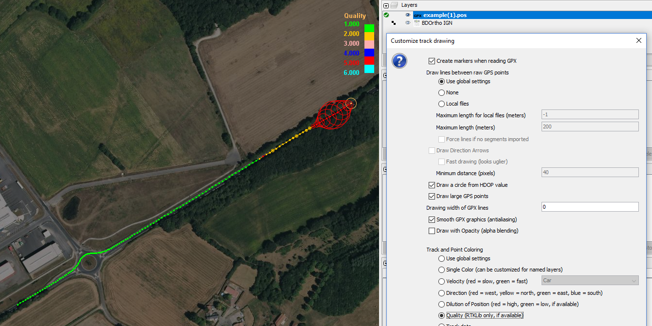
- sdn, sde, sdu -> keys and use them for drawing a circle (as "Draw a circle from HDOP value" for the gpx files)
- sdne, sdeu, sdun -> keys
I don't understand these values - age -> age key
- ratio -> ratio key
- Time (GPST, UTC, ...) -> conversion to time key
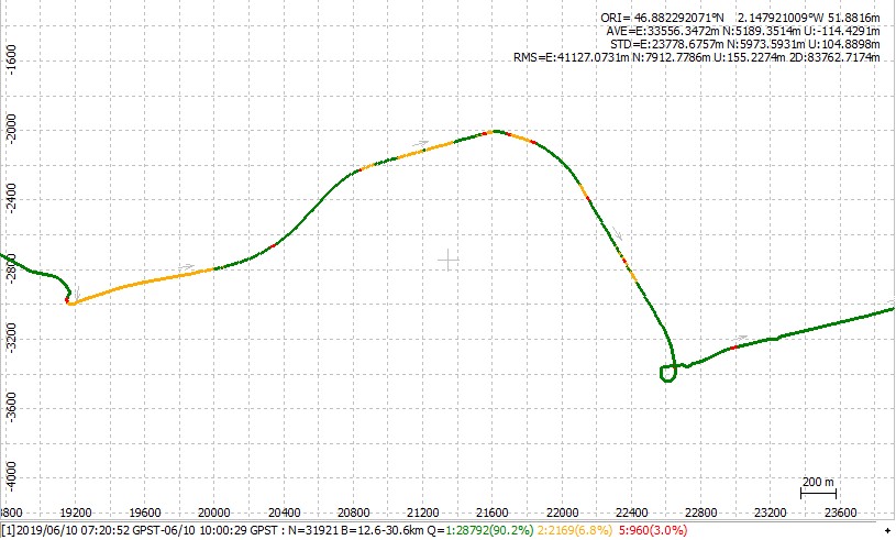
When you look at a solution in rtkplot, the first thing you look is the points' colors. The Q value set the color and the default one are:
Q=1 (fix) -> Green
Q=2 (float) -> Orange
Q=3 (sbas) -> Pink
Q=4 (dgps) -> Blue
Q=5 (single) -> Red
Q=6 (ppp) -> Light Blue

If you want to use the various RTKLib tools, there is a debian package with the GUI (rtklib-qt). This package is out of date but should works to open a .pos file in rtkplot.
For Windows, the binary files are on Github.
Attachments (6)
Change History (26)
by , 7 years ago
| Attachment: | example.pos added |
|---|
comment:1 by , 7 years ago
| Description: | modified (diff) |
|---|
comment:2 by , 7 years ago
| Priority: | minor → normal |
|---|
comment:3 by , 7 years ago
| Owner: | changed from to |
|---|---|
| Status: | new → assigned |
comment:4 by , 7 years ago
| Milestone: | → 19.08 |
|---|
by , 7 years ago
| Attachment: | rtklib_hdop.png added |
|---|
by , 7 years ago
| Attachment: | rtklib_quality.png added |
|---|


comment:8 by , 7 years ago
| Resolution: | → fixed |
|---|---|
| Status: | assigned → closed |
comment:9 by , 7 years ago
A big thank you @Don-vip!
It looks Ok.
Small remarks. When you convert a pos file to a data layer:
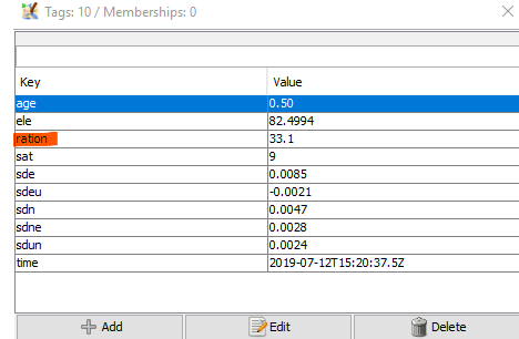
-On nodes, there is a small typo. key "ration" instead of "ratio"
-Q value is correctly used to select a color, but I don't see it as a key/value

by , 7 years ago
| Attachment: | pos_in_josm.png added |
|---|
comment:11 by , 7 years ago
In example.pos file, timedate is GPS Time. It's like UTC time but without the leap seconds. Today, GPS Time is 18 seconds ahead of UTC Time.
When I convert a pos file to a data layer. Josm apply a time offset. It looks like a local time to UTC offset (-2 Hours). That's weird.
last point in example.pos: 2019/06/08 08:23:52.800
last node in josm: 2019-06-08T06:23:52.8Z
last point in example.gpx (GPST to UTC conversion made by rtklib): 2019-06-08T08:23:34.80Z
comment:12 by , 7 years ago
| Description: | modified (diff) |
|---|
comment:13 by , 7 years ago
| Description: | modified (diff) |
|---|
comment:14 by , 7 years ago
Discussion on gps time to utc time conversion: https://coderanch.com/t/667087/java/Reconciling-Java-date-time-GPS
comment:15 by , 7 years ago
comment:17 by , 7 years ago
It's ok for me as I can set RTKLib to output the .pos file with UTC time.
comment:18 by , 7 years ago
Can you please attach an example with UTC? I must be sure how to detect if it's GPS Time or UTC.
comment:19 by , 7 years ago
GPST:
% program   : RTKPOST ver.demo5 b31a
% inp file  : C:\Users\Stéphane\Documents\RTK\data\rover_divers\2019-07-12\2019-07-12_06H\rover_2019-07-12_06-26-52.obs
% inp file  : C:\Users\Stéphane\Documents\RTK\data\rover_divers\2019-07-12\2019-07-12_06H\boug193z.19o
% inp file  : C:\Users\Stéphane\Documents\RTK\data\rover_divers\2019-07-12\2019-07-12_06H\rover_2019-07-12_06-26-52.nav
% obs start : 2019/07/12 06:28:20.4 GPST (week2061 455300.4s)
% obs end   : 2019/07/12 07:51:02.1 GPST (week2061 460262.1s)
% pos mode  : kinematic
% freqs     : L1+L2+E5b+L5
% solution  : combined
% elev mask : 15.0 deg
% dynamics  : on
% tidecorr  : off
% ionos opt : broadcast
% tropo opt : saastamoinen
% ephemeris : broadcast
% navi sys  : gps galileo beidou sbas
% amb res   : fix and hold
% val thres : 3.0
% antenna1  :                       ( 0.0000  0.0000  0.0000)
% antenna2  :                       ( 0.0000  0.0000  0.0000)
% ref pos   : 47.165589172   -1.640961015   118.0940
%
% (lat/lon/height=WGS84/ellipsoidal,Q=1:fix,2:float,3:sbas,4:dgps,5:single,6:ppp,ns=# of satellites)
%  GPST                  latitude(deg) longitude(deg)  height(m)   Q  ns   sdn(m)   sde(m)   sdu(m)  sdne(m)  sdeu(m)  sdun(m) age(s)  ratio
2019/07/12 06:28:20.400   46.987981139   -1.400660975    83.2759   1   8   0.0058   0.0041   0.0122   0.0023  -0.0017  -0.0047  -0.61   30.4
2019/07/12 06:28:20.700   46.987981154   -1.400660971    83.2786   1   8   0.0057   0.0041   0.0122   0.0023  -0.0017  -0.0047  -0.31   30.4
2019/07/12 06:28:21.000   46.987981145   -1.400660975    83.2795   1   8   0.0057   0.0041   0.0122   0.0023  -0.0017  -0.0047  -0.01   30.4
UTC:
% program   : RTKPOST ver.demo5 b31a
% inp file  : C:\Users\Stéphane\Documents\RTK\data\rover_divers\2019-07-12\2019-07-12_06H\rover_2019-07-12_06-26-52.obs
% inp file  : C:\Users\Stéphane\Documents\RTK\data\rover_divers\2019-07-12\2019-07-12_06H\boug193z.19o
% inp file  : C:\Users\Stéphane\Documents\RTK\data\rover_divers\2019-07-12\2019-07-12_06H\rover_2019-07-12_06-26-52.nav
% obs start : 2019/07/12 06:28:02.4 UTC (week2061 455300.4s)
% obs end   : 2019/07/12 07:50:44.1 UTC (week2061 460262.1s)
% pos mode  : kinematic
% freqs     : L1
% solution  : forward
% elev mask : 15.0 deg
% dynamics  : on
% tidecorr  : off
% ionos opt : broadcast
% tropo opt : saastamoinen
% ephemeris : broadcast
% navi sys  : gps galileo beidou sbas
% amb res   : fix and hold
% val thres : 3.0
% antenna1  :                       ( 0.0000  0.0000  0.0000)
% antenna2  :                       ( 0.0000  0.0000  0.0000)
% ref pos   : 47.165589172   -1.640961015   118.0940
%
% (lat/lon/height=WGS84/ellipsoidal,Q=1:fix,2:float,3:sbas,4:dgps,5:single,6:ppp,ns=# of satellites)
%  UTC                   latitude(deg) longitude(deg)  height(m)   Q  ns   sdn(m)   sde(m)   sdu(m)  sdne(m)  sdeu(m)  sdun(m) age(s)  ratio
2019/07/12 06:28:02.400   46.987973053   -1.400673775    83.2217   2   8   2.1080   1.4308   4.3602   0.8909   0.2758  -1.3394   0.39    0.0
2019/07/12 06:28:02.700   46.987972899   -1.400673506    83.1819   2   8   1.5608   1.0578   3.2397   0.6457   0.1841  -1.0408   0.69    0.0
2019/07/12 06:28:03.000   46.987972807   -1.400673339    83.1678   2   8   1.2955   0.8774   2.6924   0.5315   0.1466  -0.8790  -0.01    0.0
2019/07/12 06:28:03.300   46.987972899   -1.400673186    83.1420   2   8   1.1314   0.7660   2.3528   0.4620   0.1250  -0.7747   0.29    0.0
JST (I think it's the Japan time (UTC+9)):
% program   : RTKPOST ver.demo5 b31a
% inp file  : C:\Users\Stéphane\Documents\RTK\data\rover_divers\2019-07-12\2019-07-12_06H\rover_2019-07-12_06-26-52.obs
% inp file  : C:\Users\Stéphane\Documents\RTK\data\rover_divers\2019-07-12\2019-07-12_06H\boug193z.19o
% inp file  : C:\Users\Stéphane\Documents\RTK\data\rover_divers\2019-07-12\2019-07-12_06H\rover_2019-07-12_06-26-52.nav
% obs start : 2019/07/12 15:28:02.4 JST (week2061 455300.4s)
% obs end   : 2019/07/12 16:50:44.1 JST (week2061 460262.1s)
% pos mode  : kinematic
% freqs     : L1
% solution  : forward
% elev mask : 15.0 deg
% dynamics  : on
% tidecorr  : off
% ionos opt : broadcast
% tropo opt : saastamoinen
% ephemeris : broadcast
% navi sys  : gps galileo beidou sbas
% amb res   : fix and hold
% val thres : 3.0
% antenna1  :                       ( 0.0000  0.0000  0.0000)
% antenna2  :                       ( 0.0000  0.0000  0.0000)
% ref pos   : 47.165589172   -1.640961015   118.0940
%
% (lat/lon/height=WGS84/ellipsoidal,Q=1:fix,2:float,3:sbas,4:dgps,5:single,6:ppp,ns=# of satellites)
%  JST                   latitude(deg) longitude(deg)  height(m)   Q  ns   sdn(m)   sde(m)   sdu(m)  sdne(m)  sdeu(m)  sdun(m) age(s)  ratio
2019/07/12 15:28:02.400   46.987973053   -1.400673775    83.2217   2   8   2.1080   1.4308   4.3602   0.8909   0.2758  -1.3394   0.39    0.0
2019/07/12 15:28:02.700   46.987972899   -1.400673506    83.1819   2   8   1.5608   1.0578   3.2397   0.6457   0.1841  -1.0408   0.69    0.0
2019/07/12 15:28:03.000   46.987972807   -1.400673339    83.1678   2   8   1.2955   0.8774   2.6924   0.5315   0.1466  -0.8790  -0.01    0.0
2019/07/12 15:28:03.300   46.987972899   -1.400673186    83.1420   2   8   1.1314   0.7660   2.3528   0.4620   0.1250  -0.7747   0.29    0.0
GPS week
You won't like this one. It's the same keyword as GPS Time.
Perharps I should ask the RTKLib dev to use another keyword, something like GPSWT.
% program   : RTKPOST ver.demo5 b31a
% inp file  : C:\Users\Stéphane\Documents\RTK\data\rover_divers\2019-07-12\2019-07-12_06H\rover_2019-07-12_06-26-52.obs
% inp file  : C:\Users\Stéphane\Documents\RTK\data\rover_divers\2019-07-12\2019-07-12_06H\boug193z.19o
% inp file  : C:\Users\Stéphane\Documents\RTK\data\rover_divers\2019-07-12\2019-07-12_06H\rover_2019-07-12_06-26-52.nav
% obs start : 2019/07/12 06:28:20.4 GPST (week2061 455300.4s)
% obs end   : 2019/07/12 07:51:02.1 GPST (week2061 460262.1s)
% pos mode  : kinematic
% freqs     : L1
% solution  : forward
% elev mask : 15.0 deg
% dynamics  : on
% tidecorr  : off
% ionos opt : broadcast
% tropo opt : saastamoinen
% ephemeris : broadcast
% navi sys  : gps galileo beidou sbas
% amb res   : fix and hold
% val thres : 3.0
% antenna1  :                       ( 0.0000  0.0000  0.0000)
% antenna2  :                       ( 0.0000  0.0000  0.0000)
% ref pos   : 47.165589172   -1.640961015   118.0940
%
% (lat/lon/height=WGS84/ellipsoidal,Q=1:fix,2:float,3:sbas,4:dgps,5:single,6:ppp,ns=# of satellites)
%  GPST          latitude(deg) longitude(deg)  height(m)   Q  ns   sdn(m)   sde(m)   sdu(m)  sdne(m)  sdeu(m)  sdun(m) age(s)  ratio
2061 455300.400   46.987973053   -1.400673775    83.2217   2   8   2.1080   1.4308   4.3602   0.8909   0.2758  -1.3394   0.39    0.0
2061 455300.700   46.987972899   -1.400673506    83.1819   2   8   1.5608   1.0578   3.2397   0.6457   0.1841  -1.0408   0.69    0.0
2061 455301.000   46.987972807   -1.400673339    83.1678   2   8   1.2955   0.8774   2.6924   0.5315   0.1466  -0.8790  -0.01    0.0
There is a setting to choose the number of decimal.
UTC with 0 decimal:
% (lat/lon/height=WGS84/ellipsoidal,Q=1:fix,2:float,3:sbas,4:dgps,5:single,6:ppp,ns=# of satellites)
%  UTC                latitude(deg) longitude(deg)  height(m)   Q  ns   sdn(m)   sde(m)   sdu(m)  sdne(m)  sdeu(m)  sdun(m) age(s)  ratio
2019/07/12 06:28:02   46.987973053   -1.400673775    83.2217   2   8   2.1080   1.4308   4.3602   0.8909   0.2758  -1.3394   0.39    0.0
2019/07/12 06:28:03   46.987972899   -1.400673506    83.1819   2   8   1.5608   1.0578   3.2397   0.6457   0.1841  -1.0408   0.69    0.0
UTC with 6 decimals:
% (lat/lon/height=WGS84/ellipsoidal,Q=1:fix,2:float,3:sbas,4:dgps,5:single,6:ppp,ns=# of satellites)
%  UTC                      latitude(deg) longitude(deg)  height(m)   Q  ns   sdn(m)   sde(m)   sdu(m)  sdne(m)  sdeu(m)  sdun(m) age(s)  ratio
2019/07/12 06:28:02.399680   46.987973053   -1.400673775    83.2217   2   8   2.1080   1.4308   4.3602   0.8909   0.2758  -1.3394   0.39    0.0
2019/07/12 06:28:02.699680   46.987972899   -1.400673506    83.1819   2   8   1.5608   1.0578   3.2397   0.6457   0.1841  -1.0408   0.69    0.0
2019/07/12 06:28:02.999680   46.987972807   -1.400673339    83.1678   2   8   1.2955   0.8774   2.6924   0.5315   0.1466  -0.8790  -0.01    0.0
.pos file