

Opened 8 years ago
Last modified 4 years ago
#17102 new enhancement
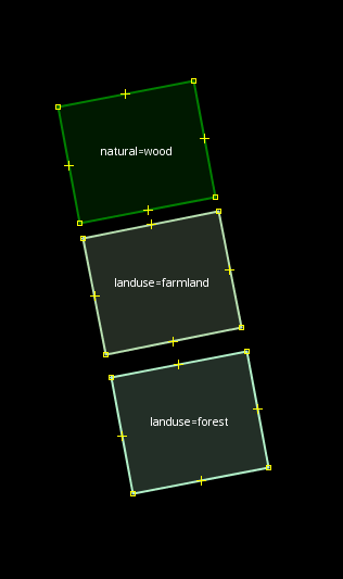
difference in area styling between forest tagged as natural=wood and landuse=forest is much greater than between landuse=forest and landuse=farmland
| Reported by: | mkoniecz | Owned by: | team |
|---|---|---|---|
| Priority: | normal | Milestone: | |
| Component: | Internal mappaint style | Version: | |
| Keywords: | template_report forest wood | Cc: |
Description (last modified by )
What steps will reproduce the problem?
- edit in area where some mappers used landuse=forest for forested area and some used natural=wood for forested area
- start adding landuse=farmland
What is the expected result?
Map in edit mode is readable
What happens instead?
Map in edit mode is highly confusing
Please provide any additional information below. Attach a screenshot if possible.
I think that the same or at least very close color for landuse=forest and natural=wood would be preferable as there is much smaller (if any) difference between landuse=forest and natural=wood
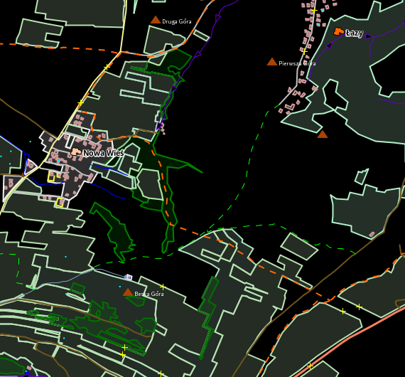
In image on the right distinguishing pale green representing forests and pale green representing fields is nearly impossible.


URL:https://josm.openstreetmap.de/svn/trunk
Repository:UUID: 0c6e7542-c601-0410-84e7-c038aed88b3b
Last:Changed Date: 2018-12-11 00:24:50 +0100 (Tue, 11 Dec 2018)
Build-Date:2018-12-11 02:32:21
Revision:14551
Relative:URL: ^/trunk

Identification: JOSM/1.5 (14551 en) Linux Ubuntu 16.04.5 LTS
Memory Usage: 670 MB / 869 MB (250 MB allocated, but free)
Java version: 1.8.0_191-b12, Oracle Corporation, Java HotSpot(TM) 64-Bit Server VM
Screen: :0.0 1366x768
Maximum Screen Size: 1366x768
Dataset consistency test: No problems found

Plugins:
+ OpeningHoursEditor (34535)
+ buildings_tools (34724)
+ continuosDownload (82)
+ imagery_offset_db (34641)
+ measurement (34529)
+ reverter (34552)
+ todo (30306)

Last errors/warnings:
- W: java.io.IOException: Attribution is not loaded yet
- W: java.io.IOException: Attribution is not loaded yet
- W: java.io.IOException: Attribution is not loaded yet
- W: java.io.IOException: Attribution is not loaded yet
- W: java.io.IOException: Attribution is not loaded yet
- W: java.io.IOException: Attribution is not loaded yet
- W: java.io.IOException: Attribution is not loaded yet
- W: java.io.IOException: Attribution is not loaded yet
- W: java.io.IOException: Attribution is not loaded yet
- W: java.io.IOException: Attribution is not loaded yet
Attachments (3)
Change History (17)
by , 8 years ago
| Attachment: | data_for_example.osm added |
|---|
by , 8 years ago
| Attachment: | land uses.png added |
|---|
comment:1 by , 8 years ago
| Summary: | difference between forest tagged as natural=wood and landuse=forest is much greater than between landuse=forest and landuse=farmland → difference in area styling between forest tagged as natural=wood and landuse=forest is much greater than between landuse=forest and landuse=farmland |
|---|
by , 8 years ago
| Attachment: | real_data_example.png added |
|---|
comment:2 by , 8 years ago
comment:3 by , 8 years ago
Or make landuse=farmland a little more yellowish? (#ccd280 for this example)

Top: natural=wood, landuse=forest, modified landuse=farmland
Bottom: natural=scrub, landuse=grass, leisure=park
comment:4 by , 8 years ago
| Description: | modified (diff) |
|---|
comment:5 by , 8 years ago
| Description: | modified (diff) |
|---|
comment:6 by , 8 years ago
Yellowish should solve that...
Yellowish would be close to schools and parkings but this features have completely different shapes and are typically not next to fields.
BTW, is it possible to apply pattern to areas rendered in JOSM? Maybe tree pattern like in OpenStreetMap Carto would help?
And thanks for reminding about other vegetation!
I see one more problem: natural=scrub and natural=wood are extremely close (if I would look at it for the first time I would expect these two to represent natural=wood and landuse=forest) (but it may be solved as a separate issue) - landuse=forest is much closer to natural=wood than to landuse=grass or natural=wood is to natural=scrub and rendering should reflect it.
comment:7 by , 8 years ago
I didn't have success in fill-image and fill-color at the same time https://josm.openstreetmap.de/wiki/Help/Styles/MapCSSImplementation#Areastyles
It looks like the pattern stands out and we can't use a background with some color.
area[natural = wood] {
        fill-color: green;
        fill-image: "tree";
        fill-opacity: 0.5;
}
(tree is just a simple tree.png file with a small tree)

I am unsure it JOSM doens't support this or if I don't know how to properly specify the style :-)
comment:8 by , 8 years ago
See #17095 which is about https://pasharm.github.io/New_basic_style_for_JOSM/New_basic_style.mapcss
comment:9 by , 5 years ago
I am planning to work on it finally, though I am aware that forest topic is quite controversial and some people are convinced that there is meaningful difference in how landuse=forest and natural=wood are used.
So, question to JOSM developers: is it OK top remove distinction between landuse=forest and natural=wood in JOSM map style rendering?
comment:10 by , 5 years ago
I'd prefer a similar but not the same rendering like same icon but little different outline color.
comment:11 by , 5 years ago
For most map renderers it probably makes sense to use the same color/style for landuse=forrest and natural=wood. For editors like JOSM I think it makes more sense to have an distinction so that users can see what is actually tagged.
I planned to make the farmland yellowish like already suggested.
comment:12 by , 4 years ago
| Component: | Core mappaint → Internal mappaint style |
|---|---|
| Keywords: | forest wood added |
follow-up: 14 comment:13 by , 4 years ago
area[landuse=farmland] {
    fill-color: farmland#b8e0b1;
}
Any idea what farmland before #b9e0b1 is doing?
I tried looking at https://josm.openstreetmap.de/wiki/Help/Styles/MapCSSImplementation#Areastyles but I jave not found an answer, the on;y case of something similar was default: colorDisplayCustomPref#FF00FF; but it has no explanation from what I see.
comment:14 by , 4 years ago
Replying to mkoniecz:
Any idea what
farmlandbefore#b9e0b1is doing?
It creates an entry in the color preferences wiki:/Help/Preferences/ColorPreference, so users of the style can easily adjust the color themself if needed. We use this for all colors in source:/trunk/resources/styles/standard/elemstyles.mapcss
real data example is from https://www.openstreetmap.org/#map=15/49.5793/21.9036 region