

#15550 closed defect (fixed)
Note tooltip needs automatic line break
| Reported by: | Klumbumbus | Owned by: | team |
|---|---|---|---|
| Priority: | normal | Milestone: | 17.11 |
| Component: | Core notes | Version: | |
| Keywords: | template_report regression | Cc: |
Description (last modified by )
The note text is too long and can't be displayed completely with the new note tooltip.
I think the width of the tooltip should be <= the current width of the mapview.

URL:http://josm.openstreetmap.de/svn/trunk
Repository:UUID: 0c6e7542-c601-0410-84e7-c038aed88b3b
Last:Changed Date: 2017-11-12 21:14:52 +0100 (Sun, 12 Nov 2017)
Build-Date:2017-11-12 20:24:34
Revision:13119
Relative:URL: ^/trunk

Identification: JOSM/1.5 (13119 de) Windows 10 64-Bit
OS Build number: Windows 10 Pro 1703 (15063)
Memory Usage: 1313 MB / 3641 MB (745 MB allocated, but free)
Java version: 1.8.0_151-b12, Oracle Corporation, Java HotSpot(TM) 64-Bit Server VM
Screen: \Display0 1680x1050
Maximum Screen Size: 1680x1050
VM arguments: [-Djava.security.manager, -Djava.security.policy=file:<java.home>\lib\security\javaws.policy, -DtrustProxy=true, -Djnlpx.home=<java.home>\bin, -Djnlpx.origFilenameArg=C:\Program Files (x86)\josm-latest-mehr-RAM.jnlp, -Djnlpx.remove=true, -Djava.util.Arrays.useLegacyMergeSort=true, -Djnlpx.heapsize=1024m,4096m, -Djnlpx.splashport=63433, -Djnlpx.jvm=<java.home>\bin\javaw.exe]
Dataset consistency test: No problems found

Plugins:
+ AddrInterpolation (33692)
+ DirectDownload (33160)
+ DirectUpload (33182)
+ FastDraw (33731)
+ HouseNumberTaggingTool (33714)
+ Mapillary (v1.5.8)
+ OpeningHoursEditor (33185)
+ ShapeTools (1230)
+ Tracer2 (33700)
+ alignways (33784)
+ apache-commons (33668)
+ apache-http (32699)
+ buildings_tools (33735)
+ contourmerge (1032)
+ editgpx (33782)
+ imagery-xml-bounds (33560)
+ imagery_offset_db (33774)
+ jogl (1.1.0)
+ log4j (32699)
+ measurement (33760)
+ osm-obj-info (1505407450)
+ photo_geotagging (33494)
+ photoadjust (33746)
+ reltoolbox (33708)
+ reverter (33572)
+ tag2link (33382)
+ tageditor (33579)
+ tagging-preset-tester (33004)
+ terracer (33608)
+ turnlanes-tagging (254)
+ turnrestrictions (33780)
+ undelete (33480)
+ utilsplugin2 (33742)
+ wikipedia (33696)

Tagging presets:
+ https://josm.openstreetmap.de/josmfile?page=Presets/OneClick&zip=1
+ https://josm.openstreetmap.de/josmfile?page=Presets/StolpersteineLight&zip=1
+ https://josm.openstreetmap.de/josmfile?page=Presets/NewTags&zip=1
+ %UserProfile%\Documents\OSM\josm\data\defaultpresets.xml
+ https://raw.githubusercontent.com/yopaseopor/traffic_signs_preset_JOSM/master/DE.zip
+ %UserProfile%\Documents\OSM\TestNew\newpresets.xml
+ %UserProfile%\Downloads\_bicycle-aqua.zip

Map paint styles:
+ %UserProfile%\Documents\OSM\josm\styles\standard\elemstyles.mapcss
- https://josm.openstreetmap.de/josmfile?page=Styles/HiDPISupport&zip=1
- https://josm.openstreetmap.de/josmfile?page=Styles/NewHighwayColors&zip=1
+ https://josm.openstreetmap.de/josmfile?page=Styles/Coloured_Streets&zip=1
- https://josm.openstreetmap.de/josmfile?page=Styles/Maxspeed&zip=1
- https://josm.openstreetmap.de/josmfile?page=Styles/Lane_and_Road_Attributes&zip=1
- https://josm.openstreetmap.de/josmfile?page=Styles/sac_scale&zip=1
- https://josm.openstreetmap.de/josmfile?page=Styles/ShowID&zip=1
- %UserProfile%\Documents\OSM\eigene styles\PriorityRoad\PriorityRoad_1.0.mapcss
- https://josm.openstreetmap.de/josmfile?page=Styles/LayerChecker&zip=1
- %UserProfile%\Documents\OSM\eigene styles\layer checker\layer checker_1.2.mapcss
- %UserProfile%\Documents\OSM\TestNew\newicons.mapcss
- https://josm.openstreetmap.de/josmfile?page=Styles/Surface&style&zip=1
- https://josm.openstreetmap.de/josmfile?page=Styles/ParkingLanes&style&zip=1
- %UserProfile%\Documents\OSM\patches\old MPs\dataquality.mapcss
- https://josm.openstreetmap.de/josmfile?page=Styles/Sidewalks&style&zip=1
- https://josm.openstreetmap.de/josmfile?page=Styles/Cycleways&style&zip=1
- https://josm.openstreetmap.de/josmfile?page=Styles/Osmc&style&zip=1
- https://raw.githubusercontent.com/species/josm-preset-wheelchair/master/sidewalks_kerbs.mapcss
- https://josm.openstreetmap.de/josmfile?page=Styles/LitObjects&zip=1
- https://josm.openstreetmap.de/josmfile?page=Styles/Lit&style&zip=1
- %UserProfile%\Documents\OSM\eigene styles\Tourenplanung.mapcss
- %UserProfile%\Documents\OSM\eigene styles\SpecificBuildingValues\SpecificBuildingValues.mapcss
- https://josm.openstreetmap.de/josmfile?page=Styles/Coloured_buildings&zip=1
- https://josm.openstreetmap.de/josmfile?page=Styles/Modified&zip=1
- https://github.com/bastik/mapcss-tools/raw/osm/mapnik2mapcss/osm-results/mapnik.zip
- %UserProfile%\Documents\OSM\eigene styles\area-symbol.zip
- http://www.freietonne.de/ft_icons/josm/FreieTonne_rules_presets_zip.php
- http://www.openrailwaymap.org/styles/standard.zip
- https://josm.openstreetmap.de/josmfile?page=Styles/MaxspeedIcons&zip=1
- https://josm.openstreetmap.de/josmfile?page=Styles/DestinationSignRelation&zip=1
- https://josm.openstreetmap.de/josmfile?page=Styles/ParkingLanes&zip=1
- https://josm.openstreetmap.de/josmfile?page=Styles/Incline&zip=1
- https://josm.openstreetmap.de/josmfile?page=Styles/PTStops&zip=1
- https://josm.openstreetmap.de/josmfile?page=Styles/AdvertisingStyle&zip=1
- https://www.dropbox.com/s/qo3ai47fpv241jf/Styles_Fixme_and_Notes.zip?raw=1
- https://github.com/gmgeo/osmic-josm-style/archive/master.zip
- https://josm.openstreetmap.de/josmfile?page=Styles/hazmat&zip=1
- https://josm.openstreetmap.de/josmfile?page=Styles/Coloured_Suburb&zip=1
- https://josm.openstreetmap.de/josmfile?page=Styles/Coloured_Postcode&zip=1
- https://josm.openstreetmap.de/josmfile?page=Styles/RecyclingMaterials&zip=1
- %UserProfile%\Documents\OSM\eigene styles\maxspeed\maxspeed_2.9_01 basierend auf 2.7_02 Zahlen.mapcss
- https://josm.openstreetmap.de/josmfile?page=Styles/Bench&zip=1
- https://josm.openstreetmap.de/josmfile?page=Styles/PublicTransportV2&zip=1

Validator rules:
+ https://raw.githubusercontent.com/<user.name>n-a-bauer/josm-validators/master/mtb.validator.mapcss
+ %UserProfile%\Documents\OSM\TestNew\new.validator.mapcss
+ https://josm.openstreetmap.de/josmfile?page=Rules/GermanySpecific&zip=1
- %UserProfile%\Documents\OSM\TestNew\germ.validator.mapcss
- https://josm.openstreetmap.de/josmfile?page=Rules/CzechRepublicAddressSystem&zip=1

Last errors/warnings:
- W: Could not fetch Wikidata label for Q2554836
- W: java.util.concurrent.ExecutionException: java.lang.RuntimeException: java.security.AccessControlException: access denied ("java.util.PropertyPermission" "os.name" "read"). Ursache: java.lang.RuntimeException: java.security.AccessControlException: access denied ("java.util.PropertyPermission" "os.name" "read"). Ursache: java.security.AccessControlException: access denied ("java.util.PropertyPermission" "os.name" "read")
Attachments (6)
Change History (24)
by , 9 years ago
| Attachment: | long_note.gif added |
|---|
comment:1 by , 9 years ago
| Description: | modified (diff) |
|---|
comment:2 by , 9 years ago
comment:5 by , 9 years ago
| Resolution: | fixed |
|---|---|
| Status: | closed → reopened |
OK the "cut at each sentence" does not work. People are writing very long sentences... But I didn't find how to resize properly/dynamically the new widget...
comment:6 by , 9 years ago
Can the the width of the mapview be accessed? If then what about line breaks at the last whitespace before the width of the tooltip reaches 75% of the width of the mapview? And for URLs maybe split them at / if this is possible.
by , 9 years ago
| Attachment: | non_URL.png added |
|---|

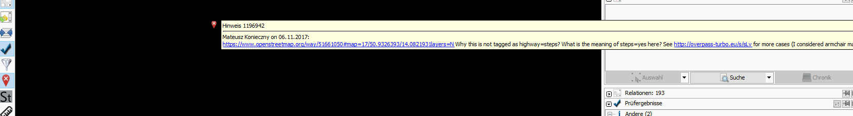
comment:10 by , 9 years ago
I can't find a perfect solution. Can you please test and tell me if it's ok now?
by , 9 years ago
| Attachment: | Notes_wide_window.png added |
|---|
by , 9 years ago
| Attachment: | Notes_small_window.png added |
|---|
by , 9 years ago
| Attachment: | Notes_long_link.png added |
|---|
comment:11 by , 9 years ago
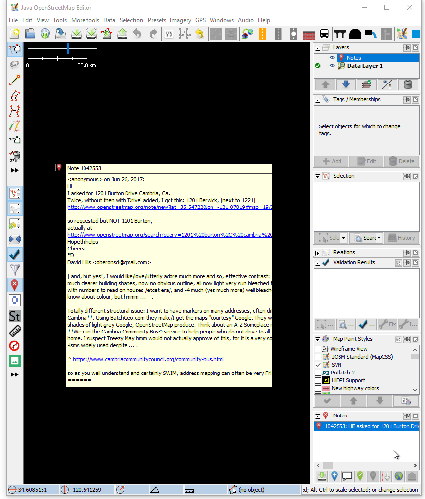
The text is cut off when the notes tooltip is resized. compare attachment:Notes_wide_window.png with attachment:Notes_small_window.png
Also long links are cut off. This doesn't look nice but could be acceptable as the links work nevertheless. See attachment:Notes_long_link.png
comment:14 by , 9 years ago
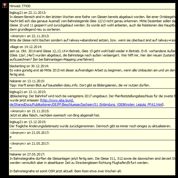
Resizing works fine now in most cases. There is still text overflow at https://www.openstreetmap.org/note/77430 attachment:note77430.png
I also just notices a small bug for the links. If a . follows the link (end of sentence) then the dot is wrongly added to the link. See https://www.openstreetmap.org/note/1182494 or https://www.openstreetmap.org/note/1067888.
For brackets it already works fine (see https://www.openstreetmap.org/note/77430).
by , 9 years ago
| Attachment: | note77430.png added |
|---|
comment:16 by , 9 years ago
Thanks! I hope you don't regret it to start working on the notes tooltip ;)
comment:17 by , 9 years ago
I didn't think it would be so difficult :) Can you please make a final test? :)
comment:18 by , 9 years ago
It's fine now and a major improvement compared to the old tooltips before r13111.
Stop moving, I can't see the node id :D