

#14103 closed enhancement (fixed)
GPX→OSM: convert additional tags for trackpoints
| Reported by: | simon04 | Owned by: | team |
|---|---|---|---|
| Priority: | normal | Milestone: | 18.07 |
| Component: | Core | Version: | |
| Keywords: | gpx trackpoint convert | Cc: | StephaneP, Klumbumbus |
Description
Follow-up of #13717.
When converting a GPX layer to an OSM data layer, also tags for trackpoints should be converted.
Attachments (2)
Change History (18)
comment:1 by , 10 years ago
follow-up: 3 comment:2 by , 10 years ago
I think that there is a misunderstanting. For me, the trackpoints are simply all the points in the gpx/nmea file.
Currently when you convert a gpx layer to a data layer, Josm takes lat/lon to place the nodes but that's all.
I'd like to see/edit the other informations like the timestamp and the elevation.
(A few months ago, I had to geolocalize a lot of indoor pictures. I was drawing the way in josm, converting it to a gpx, editing the timestamp in another tool, then reopening it in josm to geolocalize the pictures.
Editing the timestamp directly in Josm would have save me some time.
follow-up: 4 comment:3 by , 10 years ago
Replying to StephaneP:
geolocalize a lot of pictures.
For this task there is the PhotoAdjust Plugin to place the photos at their position and direction and then the Photo_Geotagging Plugin to save this in the EXIF information of the photos.
comment:4 by , 10 years ago
Replying to Klumbumbus:
For this task there is the PhotoAdjust Plugin to place the photos at their position and direction and then the Photo_Geotagging Plugin to save this in the EXIF information of the photos.
I know these useful plugins, but I said "a LOT of pictures" (more than 10 000).
You can read more here (in french) : http://www.stemani.fr/index.php?post/2016/09/16/Construire-son-V4MPod-pour-prendre-des-photos-%C3%A0-360%C2%B0-Partie-2
by , 8 years ago
| Attachment: | 14103_timestamp.png added |
|---|
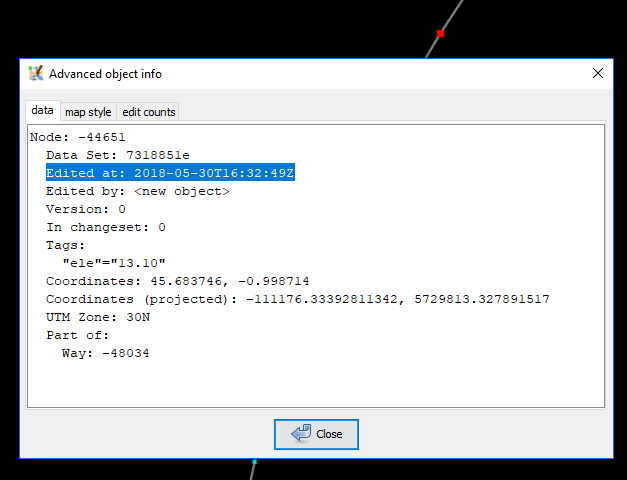
comment:5 by , 8 years ago
The time information is not lost, it's just not modifiable right now as we keep it in the node timestamp:

You can view it through advanced object info.
comment:8 by , 8 years ago
| Milestone: | → 18.07 |
|---|
by , 8 years ago
| Attachment: | gpx_track_point.PNG added |
|---|

comment:12 by , 8 years ago
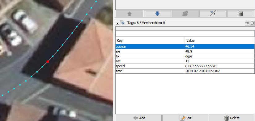
Yes, we could add a small sentence and Stéphane's picture to state that all GPX tags are copied to OSM nodes.
comment:13 by , 8 years ago
I've added some informations in the wiki.
BTW : Perhaps it could be a good idea to convert the *DOP values too.
comment:14 by , 8 years ago
I have a BIG issue with this new feature : I rework my GPS tracks with JOSM before sending them to "My Tracks" in my OSM account.
Then :
- open a raw GPX file
- use "convert to data layer" (now with version 14066 I have blue squares with "time" and "ele" tags)
- remove some useless points
- save to GPX
- upload to "my tracks"
=> Now I receive an email telling that
"Hi,
It looks like your GPX file
xxx
with the description
xxx
and no tags.
failed to import. Here's the error:
Generic XML parse error
XML parser at line 1 column 2
More information about GPX import failures and how to avoid
them can be found at: http://wiki.openstreetmap.org/index.php/GPX_Import_Failures"
Please add an option somewhere to have the same behaviour as before.
(or keep time information when exporting to GPX file)
A (small) test GPX file containing
trackpoints with useful data would be welcome.