


Opened 6 months ago
Closed 42 hours ago
#24730 closed defect (fixed)
[patch] Tile / image errors with MassGIS wmts servers
| Reported by: | Owned by: | team | |
|---|---|---|---|
| Priority: | normal | Milestone: | 26.09 |
| Component: | Core imagery | Version: | |
| Keywords: | MassGIS wmts | Cc: |
Description
What steps will reproduce the problem?
- Select a location in USA Massachusetts
- Select MassGIS 2023 or 2025 Orthos
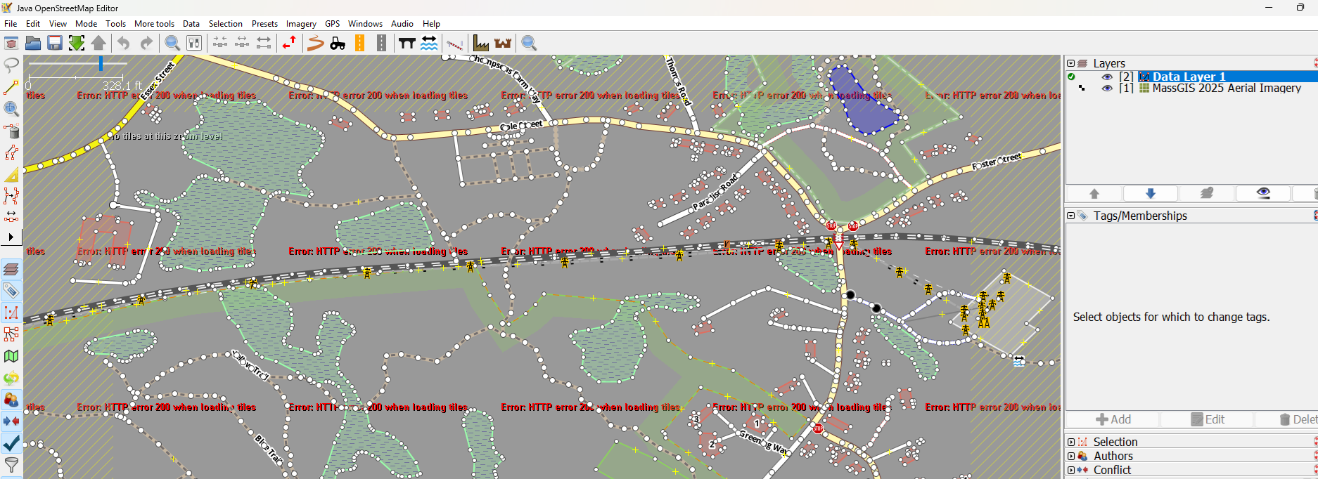
- Note tiles will not display - HTTP error 200 at any zoom level
- Create new updated wmts feed from current MassGIS documentation (ex: https://tiles.arcgis.com/tiles/hGdibHYSPO59RG1h/arcgis/rest/services/Massachusetts_Aerial_Imagery_2025/MapServer/WMTS/1.0.0/WMTSCapabilities.xml?cacheKey=9955572174118a43)
- Note same error
What is the expected result?
Proper imagery tile display
What happens instead?
HTTP error 200 in the main screen
"Image not returned for tile" error in the debug information (below)
Please provide any additional information below. Attach a screenshot if possible.
MassGIS Ortho links are provided automatically in the Imagery menus via the Wiki but same occurs if you get the latest link from MassGIS support pages and create a new feed.
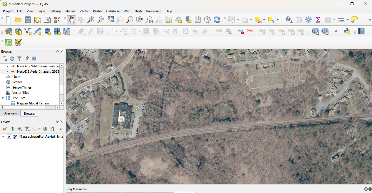
Current links are correct and valid. Work perfectly in QGIS.
Revision:19555
Build-Date:2026-03-30 09:42:59

Identification: JOSM/1.5 (19555 en) Windows 11 64-Bit
OS Build number: Windows 10 Pro 25H2 (26200)
Memory Usage: 800 MB / 24192 MB (215 MB allocated, but free)
Java version: 21.0.10+7-LTS, Azul Systems, Inc., OpenJDK 64-Bit Server VM
Look and Feel: com.sun.java.swing.plaf.windows.WindowsLookAndFeel
Screen: \Display0 2880x1800x32bpp@60Hz (scaling 1.50×1.50) \Display1 1920x1080x32bpp@60Hz (scaling 1.00×1.00)
Maximum Screen Size: 2880×1800
Best cursor sizes: 16×16→32×32, 32×32→32×32
System property file.encoding: UTF-8
System property sun.jnu.encoding: Cp1252
Locale info: en_US
Numbers with default locale: 1234567890 -> 1234567890
VM arguments: [-Djpackage.app-version=1.5.19555, -XX:MaxRAMPercentage=75.0, --add-modules=java.scripting,java.sql,javafx.controls,javafx.media,javafx.swing,javafx.web, --add-exports=java.base/sun.security.action=ALL-UNNAMED, --add-exports=java.desktop/com.sun.imageio.plugins.jpeg=ALL-UNNAMED, --add-exports=java.desktop/com.sun.imageio.spi=ALL-UNNAMED, --add-opens=java.base/java.lang=ALL-UNNAMED, --add-opens=java.base/java.nio=ALL-UNNAMED, --add-opens=java.base/jdk.internal.loader=ALL-UNNAMED, --add-opens=java.base/jdk.internal.ref=ALL-UNNAMED, --add-opens=java.desktop/javax.imageio.spi=ALL-UNNAMED, --add-opens=java.desktop/javax.swing.text.html=ALL-UNNAMED, --add-opens=java.prefs/java.util.prefs=ALL-UNNAMED, -Djpackage.app-path=%UserProfile%\AppData\Local\JOSM\JOSM.exe]
Dataset consistency test: No problems found

Plugins:
+ DirectDownload (36474)
+ DirectUpload (36474)
+ ImportImagePlugin (36474)
+ PicLayer (273)
+ Review.Changes (1.1.1)
+ apache-commons (36474)
+ ejml (36474)
+ geotools (36474)
+ jackson (36474)
+ jaxb (36474)
+ jts (36474)
+ opendata (36474)
+ reverter (36474)
+ undelete (36474)
+ utilsplugin2 (36497)

Tagging presets:
+ %UserProfile%\AppData\Local\JOSM\muskratty_presets.xml

Map paint styles:
+ https://josm.openstreetmap.de/josmfile?page=Styles/Modified&zip=1
+ https://pasharm.github.io/New_basic_style_for_JOSM/New_basic_style.mapcss

Last errors/warnings:
- 01422.062 W: Image not returned for tile: https://tiles.arcgis.com/tiles/hGdibHYSPO59RG1h/arcgis/rest/services/Massachusetts_Aerial_Imagery_2025/MapServer/WMTS/tile/1.0.0/Massachusetts_Aerial_Imagery_2025/default/default028mm/13/3024/2484 content type was: application/octet-stream
- 01422.063 W: Image not returned for tile: https://tiles.arcgis.com/tiles/hGdibHYSPO59RG1h/arcgis/rest/services/Massachusetts_Aerial_Imagery_2025/MapServer/WMTS/tile/1.0.0/Massachusetts_Aerial_Imagery_2025/default/default028mm/13/3024/2484 content type was: application/octet-stream
- 01422.069 W: Image not returned for tile: https://tiles.arcgis.com/tiles/hGdibHYSPO59RG1h/arcgis/rest/services/Massachusetts_Aerial_Imagery_2025/MapServer/WMTS/tile/1.0.0/Massachusetts_Aerial_Imagery_2025/default/default028mm/12/1511/1241 content type was: application/octet-stream
- 01422.070 W: Image not returned for tile: https://tiles.arcgis.com/tiles/hGdibHYSPO59RG1h/arcgis/rest/services/Massachusetts_Aerial_Imagery_2025/MapServer/WMTS/tile/1.0.0/Massachusetts_Aerial_Imagery_2025/default/default028mm/12/1511/1241 content type was: application/octet-stream
- 01422.119 W: Image not returned for tile: https://tiles.arcgis.com/tiles/hGdibHYSPO59RG1h/arcgis/rest/services/Massachusetts_Aerial_Imagery_2025/MapServer/WMTS/tile/1.0.0/Massachusetts_Aerial_Imagery_2025/default/default028mm/12/1512/1241 content type was: application/octet-stream
- 01422.121 W: Image not returned for tile: https://tiles.arcgis.com/tiles/hGdibHYSPO59RG1h/arcgis/rest/services/Massachusetts_Aerial_Imagery_2025/MapServer/WMTS/tile/1.0.0/Massachusetts_Aerial_Imagery_2025/default/default028mm/12/1512/1241 content type was: application/octet-stream
- 01422.157 W: Image not returned for tile: https://tiles.arcgis.com/tiles/hGdibHYSPO59RG1h/arcgis/rest/services/Massachusetts_Aerial_Imagery_2025/MapServer/WMTS/tile/1.0.0/Massachusetts_Aerial_Imagery_2025/default/default028mm/12/1512/1242 content type was: application/octet-stream
- 01422.159 W: Image not returned for tile: https://tiles.arcgis.com/tiles/hGdibHYSPO59RG1h/arcgis/rest/services/Massachusetts_Aerial_Imagery_2025/MapServer/WMTS/tile/1.0.0/Massachusetts_Aerial_Imagery_2025/default/default028mm/12/1512/1242 content type was: application/octet-stream
- 01422.162 W: Image not returned for tile: https://tiles.arcgis.com/tiles/hGdibHYSPO59RG1h/arcgis/rest/services/Massachusetts_Aerial_Imagery_2025/MapServer/WMTS/tile/1.0.0/Massachusetts_Aerial_Imagery_2025/default/default028mm/12/1511/1242 content type was: application/octet-stream
- 01422.167 W: Image not returned for tile: https://tiles.arcgis.com/tiles/hGdibHYSPO59RG1h/arcgis/rest/services/Massachusetts_Aerial_Imagery_2025/MapServer/WMTS/tile/1.0.0/Massachusetts_Aerial_Imagery_2025/default/default028mm/12/1511/1242 content type was: application/octet-stream
Attachments (2)
Change History (5)
by , 6 months ago
| Attachment: | JOSM screenshot.png added |
|---|
by , 6 months ago
| Attachment: | QGIS screenshot.png added |
|---|
QGIS screenshot rendering tiles from same source perfectly
comment:1 by , 12 days ago
| Component: | External imagery source → Core imagery |
|---|
Root cause: TMSCachedTileLoaderJob.isNotImage() discards any HTTP 200 response whose Content-Type does not start with "image". ArcGIS Online tile caches built with the "Mixed" (JPEG/PNG) format return valid JPEG/PNG bytes with Content-Type: application/octet-stream. This affects every URL form of the service (MapServer/tile, WMTS REST, WMTS KVP). Esri basemap caches using the plain JPEG format return image/jpeg and work, which is why MassGIS Basemap loads but the 2023/2025 orthos don't. iD and QGIS ignore the header and decode the bytes.
Verified fix: patched r19613 locally with the change below. MassGIS 2025 natural-color and CIR tiles now load at all zoom levels through both the WMTS and TMS entries.
--- src/org/openstreetmap/josm/data/imagery/TMSCachedTileLoaderJob.java
+++ src/org/openstreetmap/josm/data/imagery/TMSCachedTileLoaderJob.java
@@ private boolean isNotImage(...)
-            if (contentType != null && !contentType.startsWith("image") && !MVTFile.MIMETYPE.contains(contentType.toLowerCase(Locale.ROOT))) {
+            if (contentType != null && !contentType.startsWith("image")
+                    && !contentType.toLowerCase(Locale.ROOT).startsWith("application/octet-stream")
+                    && !MVTFile.MIMETYPE.contains(contentType.toLowerCase(Locale.ROOT))) {
comment:2 by , 11 days ago
| Milestone: | → 26.09 |
|---|---|
| Summary: | Tile / image errors with MassGIS wmts servers → [patch] Tile / image errors with MassGIS wmts servers |



JOSM screenshot failing to render tiles