

Opened 4 years ago
Last modified 2 years ago
#22596 new enhancement
[Patch] Elevation at current map location / Automatic download of SRTM HGT files
| Reported by: | hhtznr | Owned by: | team |
|---|---|---|---|
| Priority: | normal | Milestone: | |
| Component: | Plugin elevationprofile | Version: | |
| Keywords: | elevation, SRTM HGT, current map location, automatic download | Cc: | OliverW |
Description (last modified by )
What?
I wrote this patch, which will display the elevation at the current location on the map next to the coordinates in the MapStatus line. Optionally, the necessary SRTM HGT files providing the elevation can automatically be downloaded, if they are missing on disk.
Why?
This is typical functionality in most map applications, but it is missing in JOSM. Elevation at the current map location (mouse pointer) can be useful in determining the proper direction of waterways, the location of summits etc.
How does it work?
It builds on HgtReader from ElevationProfile plugin written by Oliver Wieland. HgtReader checks whether the HGT file covering the current map location is available on disk. If so, it reads it into memory and determines the elevation at the current location.
I extended HgtReader with HgtDownloader, which will download any missing HGT file in a background thread from NASA's Land Processes Distributed Active Archive Center (LP DAAC) at https://e4ftl01.cr.usgs.gov/MEASURES/SRTMGL3.003/2000.02.11/.
I created a preferences tab, where the elevation feature can be enabled and where optional auto-downloading can turned on.
Why not as plugin?
I did not see a way, how to feed the current map location (mouse pointer) into a plugin.
What's the content of the patch?
New files:
- src/org/openstreetmap/josm/data/elevation/ElevationHelper.java (from Oliver Wieland)
- src/org/openstreetmap/josm/data/elevation/HgtDownloader.java
- src/org/openstreetmap/josm/data/elevation/HgtDownloadListener.java
- src/org/openstreetmap/josm/data/elevation/HgtPreferences.java
- src/org/openstreetmap/josm/data/elevation/HgtReader.java (builds on Oliver Wieland)
- src/org/openstreetmap/josm/data/elevation/gpx/GeoidCorrectionKind.java (from Oliver Wieland)
- src/org/openstreetmap/josm/gui/preferences/elevation/HgtPreference.java
- src/org/openstreetmap/josm/gui/preferences/elevation/HgtPreferencesPanel.java
- resources/images/preferences/elevation.svg
- resources/images/statusline/ele.svg
Updated files:
- src/org/openstreetmap/josm/gui/MapStatus.java
- src/org/openstreetmap/josm/gui/preferences/PreferenceTabbedPane.java
What next?
I would appreciate it, if the demonstrated functionality could be integrated into mainline JOSM.
Screenshots


Attachments (7)
Change History (37)
by , 4 years ago
| Attachment: | JOSM_18616_Elevation_git_diff.txt added |
|---|
by , 4 years ago
| Attachment: | JOSM_18616_Elevation_new_updated_src_files.tar.gz added |
|---|
Archive with new and updated source files
by , 4 years ago
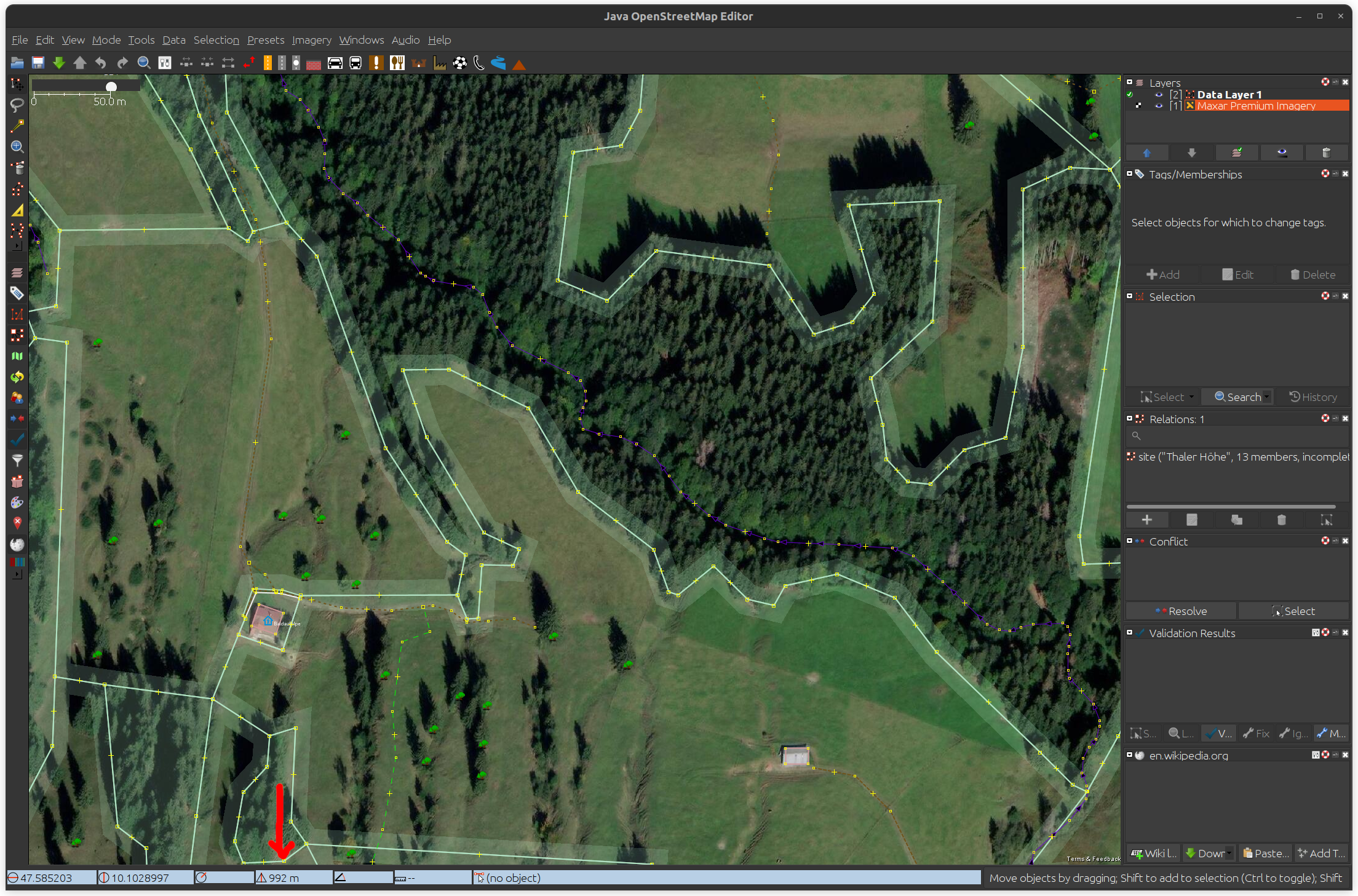
| Attachment: | JOSM_with_elevation_in_MapSatus.png added |
|---|
Screenshot of elevation information in MapStatus line
by , 4 years ago
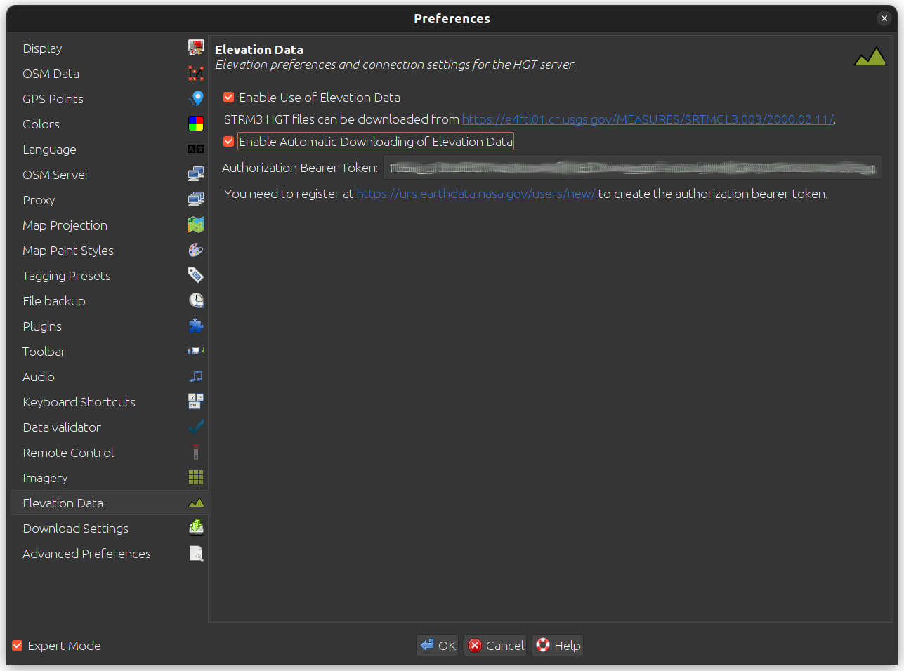
| Attachment: | JOSM_Elevation_Data_Preferences.png added |
|---|
Screenshot of elevation data preferences tab
comment:1 by , 4 years ago
| Description: | modified (diff) |
|---|
comment:2 by , 4 years ago
| Description: | modified (diff) |
|---|
comment:3 by , 4 years ago
| Description: | modified (diff) |
|---|
follow-up: 5 comment:4 by , 4 years ago
Why not as plugin?
I did not see a way, how to feed the current map location (mouse pointer) into a plugin.
It is possible to do so:
        Point mousePosition = MainApplication.getMap().mapView.getMousePosition();
        LatLon latLon = MainApplication.getMap().mapView.getLatLon(mousePosition.getX(), mousePosition.getY());
Also, you should have renamed attachment:JOSM_18616_Elevation_git_diff.txt such that it ended with .diff or .patch.
Anyway, skimming through your patch:
- Why unzip the HGT file? It takes more space on disk, and there are several methods in Java to get a decompressed input stream. If you profiled it, and it took fewer resources, that would be helpful to know.
- Please don't set the
HttpClientfactory. (HttpClient.setFactory(Http1Client::new);). This should only be set by JOSM itself or a plugin which provides its own factory (like the http2 plugin). - I'm not a fan of the TODO comments sprinkled throughout the code
- Is there any documentation for the login process for the government server? Does it use OAuth 2.0? If so, does it allow redirects to localhost/127.0.0.1? I've got a WIP patch for OAuth 2.0 support in JOSM, and it takes advantage of the remote control server to receive initial server redirect.
follow-up: 6 comment:5 by , 4 years ago
Replying to taylor.smock:
Why not as plugin?
I did not see a way, how to feed the current map location (mouse pointer) into a plugin.
It is possible to do so:
        Point mousePosition = MainApplication.getMap().mapView.getMousePosition();
        LatLon latLon = MainApplication.getMap().mapView.getLatLon(mousePosition.getX(), mousePosition.getY());
Thank you for pointing this out. It helped me to figure out how to do it outside the scope of MapStatus. I think, your proposal would not work to get the position as a result of mouse motion. But being pointed to mapView, I came across that it could be done like this, copying the listener code from MapStatus into an own plugin class and putting it in Plugin.mapFrameInitialized:
@Override
public void mapFrameInitialized(MapFrame oldFrame, MapFrame newFrame) {
    super.mapFrameInitialized(oldFrame, newFrame);

    if (newFrame != null) {
        newFrame.mapView.addMouseMotionListener(new MouseMotionListener() {
            @Override
            public void mouseDragged(MouseEvent e) {
                mouseMoved(e);
            }

            @Override
            public void mouseMoved(MouseEvent e) {
                if (newFrame.mapView.getCenter() == null)
                    return;
                // Do not update the view if ctrl or right button is pressed.
                if ((e.getModifiersEx() & (MouseEvent.CTRL_DOWN_MASK | MouseEvent.BUTTON3_DOWN_MASK)) == 0)
                    updateEleText(newFrame.mapView.getLatLon(e.getX(), e.getY()));
            }
        });

        }
    }
}
Also, you should have renamed attachment:JOSM_18616_Elevation_git_diff.txt such that it ended with
.diffor.patch.
Anyway, skimming through your patch:
- Why unzip the HGT file? It takes more space on disk, and there are several methods in Java to get a decompressed input stream. If you profiled it, and it took fewer resources, that would be helpful to know.
Modern file systems use compression so it does not take more space when the original file is decompressed. Should I create a config option so the user can decide whether to decompress the downloaded files or to leave them as-is?
- Please don't set the
HttpClientfactory. (HttpClient.setFactory(Http1Client::new);). This should only be set by JOSM itself or a plugin which provides its own factory (like the http2 plugin).
Is this better?
Http1Client httpClient = new Http1Client(url, "GET");
- I'm not a fan of the TODO comments sprinkled throughout the code
NP, can be deleted.
- Is there any documentation for the login process for the government server? Does it use OAuth 2.0? If so, does it allow redirects to localhost/127.0.0.1? I've got a WIP patch for OAuth 2.0 support in JOSM, and it takes advantage of the remote control server to receive initial server redirect.
They have documentation here: https://urs.earthdata.nasa.gov/documentation
It's not really explained in depth, but it seems they use OAuth2: https://urs.earthdata.nasa.gov/documentation/for_users/oauth2
They also have a Java code example, which uses java.net.HttpURLConnection: https://urs.earthdata.nasa.gov/documentation/for_users/data_access/java
However, it uses basic authorization with username + password instead of the authorization bearer. Would this be preferred? I thought otherwise.
Sorry, I'm absolutely no expert on this web stuff. So some support on this would be appreciated.
comment:6 by , 4 years ago
Replying to hhtznr:
Modern file systems use compression so it does not take more space when the original file is decompressed. Should I create a config option so the user can decide whether to decompress the downloaded files or to leave them as-is?
Many of the common linux filesystems do not enable transparent compression by default. BTRFS requires the user to pick a compression type, ext4 doesn't support transparent compression, and so on.
- Please don't set the
HttpClientfactory. (HttpClient.setFactory(Http1Client::new);). This should only be set by JOSM itself or a plugin which provides its own factory (like the http2 plugin).Is this better?
Http1Client httpClient = new Http1Client(url, "GET");
Not really. You should be using the factory (HttpClient.create), and the variable type should just be the base HttpClient type instead of a specific subclass. All of the methods you called on Http1Client and Http1Response are available in the super class/interface (HttpClient and HttpResponse respectively).
- Is there any documentation for the login process for the government server? Does it use OAuth 2.0? If so, does it allow redirects to localhost/127.0.0.1? I've got a WIP patch for OAuth 2.0 support in JOSM, and it takes advantage of the remote control server to receive initial server redirect.
They have documentation here: https://urs.earthdata.nasa.gov/documentation
It's not really explained in depth, but it seems they use OAuth2: https://urs.earthdata.nasa.gov/documentation/for_users/oauth2
They also have a Java code example, which uses
java.net.HttpURLConnection: https://urs.earthdata.nasa.gov/documentation/for_users/data_access/java
However, it uses basic authorization with username + password instead of the authorization bearer. Would this be preferred? I thought otherwise.
Sorry, I'm absolutely no expert on this web stuff. So some support on this would be appreciated.
It does look like they do use OAuth 2, and that would be greatly preferred over username + password. See #20768 for the WIP patch for JOSM OAuth 2 support.
follow-up: 8 comment:7 by , 4 years ago
Is a "display local elevation" feature of interest for integration into the main application or should I rather convert my proposal into a plugin?
follow-up: 9 comment:8 by , 4 years ago
Replying to hhtznr:
Is a "display local elevation" feature of interest for integration into the main application or should I rather convert my proposal into a plugin?
I'd probably just apply the patch to the ElevationProfile plugin.
comment:9 by , 4 years ago
Replying to taylor.smock:
Replying to hhtznr:
Is a "display local elevation" feature of interest for integration into the main application or should I rather convert my proposal into a plugin?
I'd probably just apply the patch to the
ElevationProfileplugin.
OK, I'll consider your valued feedback on HttpClient and decompression, incorporate my code into ElevationProfile and send a new diff/patch.
by , 4 years ago
| Attachment: | JOSM_ElevationProfile_18494.diff added |
|---|
Git diff of reworked elevation patch against ElevationProfile
comment:10 by , 4 years ago
I integrated my code into ElevationProfile plugin and created this diff: https://josm.openstreetmap.de/attachment/ticket/22596/JOSM_ElevationProfile_18494.diff
An incompatible change is the directory, where the HGT files are saved.
The original code used:
for (String location : Preferences.getAllPossiblePreferenceDirs()) {
    String fullPath = new File(location + File.separator + "elevation", file).getPath();
    [...]
}
I use ...
public static final File DEFAULT_HGT_DIRECTORY =
    Paths.get(Preferences.main().getDirs().getCacheDirectory(true).toString(), "elevation", "SRTM3").toFile();
... to make sure, I have a directory that is writable when downloading and to ensure that SRTM3 HGT files can be distinguished from other elevation data in case that this should be necessary in the future.
What is your opinion on this patch?
comment:11 by , 4 years ago
| Component: | Core → Plugin elevationprofile |
|---|---|
| Owner: | changed from to |
| Version: | latest |
comment:12 by , 4 years ago
| Cc: | added |
|---|---|
| Owner: | changed from to |
comment:14 by , 3 years ago
I published my Elevation plugin on GitHub: https://github.com/hhtznr/JOSM-Elevation-Plugin
It does not include the other functionality from the ElevationProfile plugin. So it will not interfere.
comment:15 by , 3 years ago
@hhtznr: Is it possible to download elevation data at specific node locations?
If yes, I may fork it :)
comment:16 by , 3 years ago
Provided a suitable SRTM file is available, the SRTM file reader returns the elevation value where the location in the SRTM tile raster is closest to a given org.openstreetmap.josm.data.coor.ILatLon (no interpolation). Therefore, it could also be used to get the approximate elevation of a node on the map.
However, as the current functionality is focused on providing the elevation at the mouse pointer location on the map, file reading and downloading is done in a non-blocking manner (separate threads). Due to this, the SRTM file reader will report a data void instead of a usable elevation value as long as the relevant SRTM tile has not been cached.
From my perspective, obtaining the elevation of a node should encompass interpolation and waiting for usable values to be available.
follow-ups: 18 19 29 30 comment:17 by , 3 years ago
Replying to hhtznr:
Did you ever consider this proposal/patch?
I forget stuff. And sometimes more important things come up. Like fixing CI issues.
If a patch doesn't have a response after two weeks, ping it (and cc me in the ticket if I'm not already involved). And keep pinging until someone (probably me) responds.
Anyway, as I noted in comment:6, the authentication information can be obtained via oauth 2. JOSM has support for oauth 2. I would strongly prefer to use that support.
Beyond that, I'm not a fan of the singleton instance for HgtReader. In most cases, if you "need" a singleton, you can get away with static methods. There are a few exceptions. In this case, I think the exception is for having multiple instances with different configuration. In this case, there is only one instance of a new HgtReader; in the singleton method. I probably would have made a private static class for the HgtDownloadListener (the other possible exception).
I'll try to find time to take a deeper look this week.
comment:18 by , 3 years ago
Replying to taylor.smock:
Replying to hhtznr:
Did you ever consider this proposal/patch?
I forget stuff. And sometimes more important things come up. Like fixing CI issues.
If a patch doesn't have a response after two weeks, ping it (and cc me in the ticket if I'm not already involved). And keep pinging until someone (probably me) responds.
Anyway, as I noted in comment:6, the authentication information can be obtained via oauth 2. JOSM has support for oauth 2. I would strongly prefer to use that support.
Beyond that, I'm not a fan of the singleton instance for
HgtReader. In most cases, if you "need" a singleton, you can get away withstaticmethods. There are a few exceptions. In this case, I think the exception is for having multiple instances with different configuration. In this case, there is only one instance of anewHgtReader; in the singleton method. I probably would have made aprivate static classfor theHgtDownloadListener(the other possible exception).
I'll try to find time to take a deeper look this week.
Thank you for the reply. I'm planning to work on the plugin during the cold period and would propose pinging you for a review afterwards.
My from-the-scratch version at https://github.com/hhtznr/JOSM-Elevation-Plugin already contains a few features that were not included in last year's patch:
- Handling of SRTM1 datasets in addition to SRTM3
- Size limit of in-memory cache
- More work delegation to threads
- Disabling of elevation functionality if zoomed out too much
- Timer triggered caching of SRTM tiles to cover complete map view
I have more ideas in mind and will also consider your recommendations.
comment:19 by , 3 years ago
Replying to taylor.smock:
Replying to hhtznr:
Anyway, as I noted in comment:6, the authentication information can be obtained via oauth 2. JOSM has support for oauth 2. I would strongly prefer to use that support.
I considered your proposal to use OAuth2 for authentication at NASA Earthdata servers instead of using an authorization bearer token.
It is straightforward, to do it the way proposed by NASA ...
- General documentation: https://urs.earthdata.nasa.gov/documentation/for_users/sso_process_overview
- Java example: https://urs.earthdata.nasa.gov/documentation/for_users/data_access/java
... following their redirects, doing basic authentication when arriving at their URS server and then being granted session authorization.
However, I do not see how to get it to work based on the JOSM API. There are two major obstacles:
- The OAuth2 code in JOSM looks very OSM centric to me, for example the last two assignments in the
OAuthParametersconstructor:public OAuthParameters(String consumerKey, String consumerSecret, String requestTokenUrl, String accessTokenUrl, String authoriseUrl, String osmLoginUrl, String osmLogoutUrl) { this.consumerKey = consumerKey; this.consumerSecret = consumerSecret; this.requestTokenUrl = requestTokenUrl; this.accessTokenUrl = accessTokenUrl; this.authoriseUrl = authoriseUrl; this.osmLoginUrl = osmLoginUrl; this.osmLogoutUrl = osmLogoutUrl; }So, at first glance, it looks as if it might be necessary to subclass/override some of the code to get it to work with non-OSM servers.
HttpClienthandles redirects immediately in itsconnect()method, where it removes the authorization header when being redirected. This is a good idea when being redirected somewhere to prevent leaking the auth data. But this prevents doing OAuth the NASA way following their redirects and putting the header in place when arriving at their auth host. Unluckily, I cannot find a documented approach how to directly connect their URS server in order to get auth done without the need to follow redirects.
The two solutions that I see at the moment are:
- Stick to
HttpClientand at the same time stick to the authorization bearer token. This is not a perfect solution as the user not only has to generate the token once on the NASA pages, but each time that a generated token has expired.
- Use the NASA proposed OAuth2 approach. This would mean dropping
HttpClientin favor ofHttpURLConnection, not using JOSM OAuth2 code at all, but trying to make use ofCredentialsManagerto get username and password stored the JOSM way.
Can you give me a few hints how to resolve this? Is there a more elegant third way that I just don't see?
follow-ups: 21 22 comment:20 by , 3 years ago
However, I do not see how to get it to work based on the JOSM API. There are two major obstacles:
- You want
OAuth20Parameters, notOAuthParameters. It doesn't (currently) refresh the token, but with additional users, it will be worthwhile to add that ability. - We had an issue where we were sending authentication information to servers that were not the original server. Example: osm -> aws for GPX traces. Feel free to file a patch so that we can send authentication information to servers that match the following:
- Same protocol (
http != https) --http -> httpsis probably fine, but I'd rather not define the security of the protocol. - Same host (
data.usgs.gov != other.data.usgs.gov)
- Same protocol (
comment:21 by , 3 years ago
Replying to taylor.smock:
However, I do not see how to get it to work based on the JOSM API. There are two major obstacles:
- You want
OAuth20Parameters, notOAuthParameters. It doesn't (currently) refresh the token, but with additional users, it will be worthwhile to add that ability.
I will have a look. I missed this out as I am currently building the plugin for an older version of JOSM.
- We had an issue where we were sending authentication information to servers that were not the original server. Example: osm -> aws for GPX traces. Feel free to file a patch so that we can send authentication information to servers that match the following:
- Same protocol (
http != https) --http -> httpsis probably fine, but I'd rather not define the security of the protocol.- Same host (
data.usgs.gov != other.data.usgs.gov)
With NASA, we would always want to send auth information to a different host. However, we know the hostname in advance as it is specified. We want to get the desired resource from e4ftl01.cr.usgs.gov, but we will be redirected to urs.earthdata.nasa.gov for auth and redirected back to the resource on the initial host afterwards.
by , 3 years ago
| Attachment: | HttpClient.diff added |
|---|
by , 3 years ago
| Attachment: | JosmNasaEarthdataAuthTest.java added |
|---|
follow-up: 23 comment:22 by , 3 years ago
Replying to taylor.smock:
However, I do not see how to get it to work based on the JOSM API. There are two major obstacles:
- You want
OAuth20Parameters, notOAuthParameters. It doesn't (currently) refresh the token, but with additional users, it will be worthwhile to add that ability.- We had an issue where we were sending authentication information to servers that were not the original server. Example: osm -> aws for GPX traces. Feel free to file a patch so that we can send authentication information to servers that match the following:
- Same protocol (
http != https) --http -> httpsis probably fine, but I'd rather not define the security of the protocol.- Same host (
data.usgs.gov != other.data.usgs.gov)
With the OAuth20[...] API from JOSM it also does not seem to be feasible to authenticate at the NASA servers. But the good thing is that it is not necessary at all and the approach proposed by NASA for contacting their servers is much simpler.
I attached a small patch for HttpClient and a small demo how to use it in this scope.
- https://josm.openstreetmap.de/attachment/ticket/22596/HttpClient.diff
- https://josm.openstreetmap.de/attachment/ticket/22596/JosmNasaEarthdataAuthTest.java
The patch is not elegant, it is just intended to show how HttpClient could be adapted to cooperate.
When running the test ...
Accessing resource https://e4ftl01.cr.usgs.gov/MEASURES/SRTMGL3.003/2000.02.11/N44E010.SRTMGL3.hgt.zip.xml
2023-11-17 19:17:56.280 INFO: GET https://e4ftl01.cr.usgs.gov/MEASURES/SRTMGL3.003/2000.02.11/N44E010.SRTMGL3.hgt.zip.xml -> HTTP/1.1 302 (862 ms; 503 B)
2023-11-17 19:17:56.283 INFO: Download redirected to https://urs.earthdata.nasa.gov/oauth/authorize?scope=uid&app_type=401&client_id=ijpRZvb9qeKCK5ctsn75Tg&response_type=code&redirect_uri=https%3A%2F%2Fe4ftl01.cr.usgs.gov%2Foauth&state=aHR0cHM6Ly9lNGZ0bDAxLmNyLnVzZ3MuZ292L01FQVNVUkVTL1NSVE1HTDMuMDAzLzIwMDAuMDIuMTEvTjQ0RTAxMC5TUlRNR0wzLmhndC56aXAueG1s
2023-11-17 19:17:56.923 INFO: GET https://urs.earthdata.nasa.gov/oauth/authorize?scope=uid&app_type=401&client_id=ijpRZvb9qeKCK5ctsn75Tg&response_type=code&redirect_uri=https%3A%2F%2Fe4ftl01.cr.usgs.gov%2Foauth&state=aHR0cHM6Ly9lNGZ0bDAxLmNyLnVzZ3MuZ292L01FQVNVUkVTL1NSVE1HTDMuMDAzLzIwMDAuMDIuMTEvTjQ0RTAxMC5TUlRNR0wzLmhndC56aXAueG1s -> HTTP/1.1 302 (639 ms)
2023-11-17 19:17:56.923 INFO: Download redirected to https://e4ftl01.cr.usgs.gov/oauth?code=ep1Pmzw6iRYMHSaAVAZButda8oaUBJQnm4ZtRUX-4zYDzfmn3ILpiJhawmgV22u7ZA&state=aHR0cHM6Ly9lNGZ0bDAxLmNyLnVzZ3MuZ292L01FQVNVUkVTL1NSVE1HTDMuMDAzLzIwMDAuMDIuMTEvTjQ0RTAxMC5TUlRNR0wzLmhndC56aXAueG1s
2023-11-17 19:17:56.924 INFO: Download redirected to different host (urs.earthdata.nasa.gov -> e4ftl01.cr.usgs.gov), removing authorization headers
2023-11-17 19:17:57.776 INFO: GET https://e4ftl01.cr.usgs.gov/oauth?code=ep1Pmzw6iRYMHSaAVAZButda8oaUBJQnm4ZtRUX-4zYDzfmn3ILpiJhawmgV22u7ZA&state=aHR0cHM6Ly9lNGZ0bDAxLmNyLnVzZ3MuZ292L01FQVNVUkVTL1NSVE1HTDMuMDAzLzIwMDAuMDIuMTEvTjQ0RTAxMC5TUlRNR0wzLmhndC56aXAueG1s -> HTTP/1.1 302 (851 ms; 271 B)
2023-11-17 19:17:57.777 INFO: Download redirected to https://e4ftl01.cr.usgs.gov/MEASURES/SRTMGL3.003/2000.02.11/N44E010.SRTMGL3.hgt.zip.xml
2023-11-17 19:17:58.352 INFO: GET https://e4ftl01.cr.usgs.gov/MEASURES/SRTMGL3.003/2000.02.11/N44E010.SRTMGL3.hgt.zip.xml -> HTTP/1.1 200 (575 ms; 2.86 kB)
<?xml version="1.0" encoding="UTF-8"?>
<!DOCTYPE GranuleMetaDataFile SYSTEM "http://ecsinfo.gsfc.nasa.gov/ECSInfo/ecsmetadata/dtds/DPL/ECS/ScienceGranuleMetadata.dtd">
[....]

Accessing resource https://e4ftl01.cr.usgs.gov/MEASURES/SRTMGL3.003/2000.02.11/N44E011.SRTMGL3.hgt.zip.xml
2023-11-17 19:17:58.915 INFO: GET https://e4ftl01.cr.usgs.gov/MEASURES/SRTMGL3.003/2000.02.11/N44E011.SRTMGL3.hgt.zip.xml -> HTTP/1.1 200 (548 ms; 2.87 kB)
<?xml version="1.0" encoding="UTF-8"?>
<!DOCTYPE GranuleMetaDataFile SYSTEM "http://ecsinfo.gsfc.nasa.gov/ECSInfo/ecsmetadata/dtds/DPL/ECS/ScienceGranuleMetadata.dtd">
[...]
... we are redirected for auth to the URS server the first time that we request a resource from the download server. There, we do basic auth with our Earthdata credentials. The next time, the download server immediately provides us the requested resource. We are recognized based on a session cookie.
What is your opinion on this solution?
follow-up: 24 comment:23 by , 3 years ago
The patch is not elegant, it is just intended to show how
HttpClientcould be adapted to cooperate.
It's not bad I'd say.
comment:24 by , 3 years ago
follow-up: 26 comment:25 by , 3 years ago
I don't think so. Poke this ticket in a few days so I don't forget about this. I just did a release, and I have a policy of not doing non-urgent fixes for a few days prior and after the release.
comment:26 by , 3 years ago
Replying to taylor.smock:
I don't think so. Poke this ticket in a few days so I don't forget about this. I just did a release, and I have a policy of not doing non-urgent fixes for a few days prior and after the release.
This is the requested friendly reminder on the HttpClient patch enabling auth upon redirection to a predefined host:
https://josm.openstreetmap.de/attachment/ticket/22596/HttpClient.diff
comment:29 by , 3 years ago
Replying to taylor.smock:
Anyway, as I noted in comment:6, the authentication information can be obtained via oauth 2. JOSM has support for oauth 2. I would strongly prefer to use that support.
With commit 3e08a78, I have updated the Elevation plugin to use the JOSM OAuth 2.0 implementation for authentication based on the authorization bearer token that an Earthdata user can create on the Generate Token tab at Earthdata Login. (I will implement an alternative based on username and password using the patched HttpClient in a later commit.)
To provide feedback on the JOSM OAuth 2.0 implementation:
- It is quite some research and implementation effort to get the bearer token into the HTTP header this way.
- In the previous version, I used a dedicated pref parameter to store the token. And I simply added an authorization header containing
Bearer _BEARER_TOKEN_to theHttpClient. - Now, the bearer token is still stored in the same preferences file, but there is a lot of additional information with most of it just beeing added because the parameters are not allowed to be
null. - This piece of code shows what must be added in addition to
token_typeandaccess_tokento satisfy the constraints of the implementation:
private static OAuth20Token createEarthdataOAuthToken(String bearerToken) {
    // Either client ID or bearer token must be non-null/non-blank
    if (bearerToken == null || Utils.isBlank(bearerToken))
        return null;
    JsonObjectBuilder jsonObjectBuilder = Json.createObjectBuilder();
    jsonObjectBuilder.add("token_type", "bearer");
    jsonObjectBuilder.add("access_token", bearerToken);
    String json = jsonObjectBuilder.build().toString();

    String earthDataURS = "https://" + EARTHDATA_SSO_HOST + "/";
    String earthDataDL = "https://" + EARTHDATA_DOWNLOAD_HOST + "/";
    // Earthdata neither provides us a client ID nor a client secret
    String clientId = "";
    String clientSecret = null;
    // Following two URLs are set because the parameters may not be null, but are
    // never used
    String authorizeUrl = earthDataURS;
    String redirectUri = earthDataURS;
    // These two parameters need to be set to the URL of the SRTM download server
    // Otherwise, OAuth20Parameters will refuse to be initialized and
    // OAuthToken.sign(HttpClient) will refuse to do its job
    String tokenUrl = earthDataDL;
    String apiUrl = earthDataDL;

    OAuth20Parameters parameters = new OAuth20Parameters(clientId, clientSecret, tokenUrl, authorizeUrl, apiUrl,
            redirectUri);
    try {
        return new OAuth20Token(parameters, json);
    } catch (OAuth20Exception e) {
        Logging.error("Elevation: " + e);
        return null;
    }
}
- It is to note that we do not know a client ID in this specific case. As it may not be
null, I set it to a blank string in order to pass the null check in theOAuth20Parametersconstructor. - It would be more convenient if fields like
OAuth20Token.ACCESS_TOKENandOAuth20Token.TOKEN_TYPEwere public. - When I got it right from OAuth.com, OAuth 2.0 is quite flexible with respect to the parameters that are in place for a specific use case. Therefore, if it is desired that plugins make use of the OAuth 2.0 implementation, it would be of advantage that more flexible constructors for
OAuth20ParametersandOAuth20Tokenare provided which are not based on assumptions that are specific to OSM.
comment:30 by , 2 years ago
Replying to taylor.smock:
I'll try to find time to take a deeper look this week.
Now is the time that I would like to come back to the offered review. I have implemented all the features I had in mind. And I have considered your recommendations. The plugin is working stable for me. So far, no bugs were reported.
The Elevation plugin source is found here: https://github.com/hhtznr/JOSM-Elevation-Plugin
Documentation on configuration and usage is found here: https://wiki.openstreetmap.org/wiki/JOSM/Plugins/Elevation
Looking forward to your feedback!
Git diff of elevation patch