

#21871 closed defect (fixed)
Mapillary plugin displays wrong numerical values
| Reported by: | Eric_S | Owned by: | taylor.smock |
|---|---|---|---|
| Priority: | normal | Milestone: | |
| Component: | Plugin mapillary | Version: | |
| Keywords: | template_report | Cc: |
Description
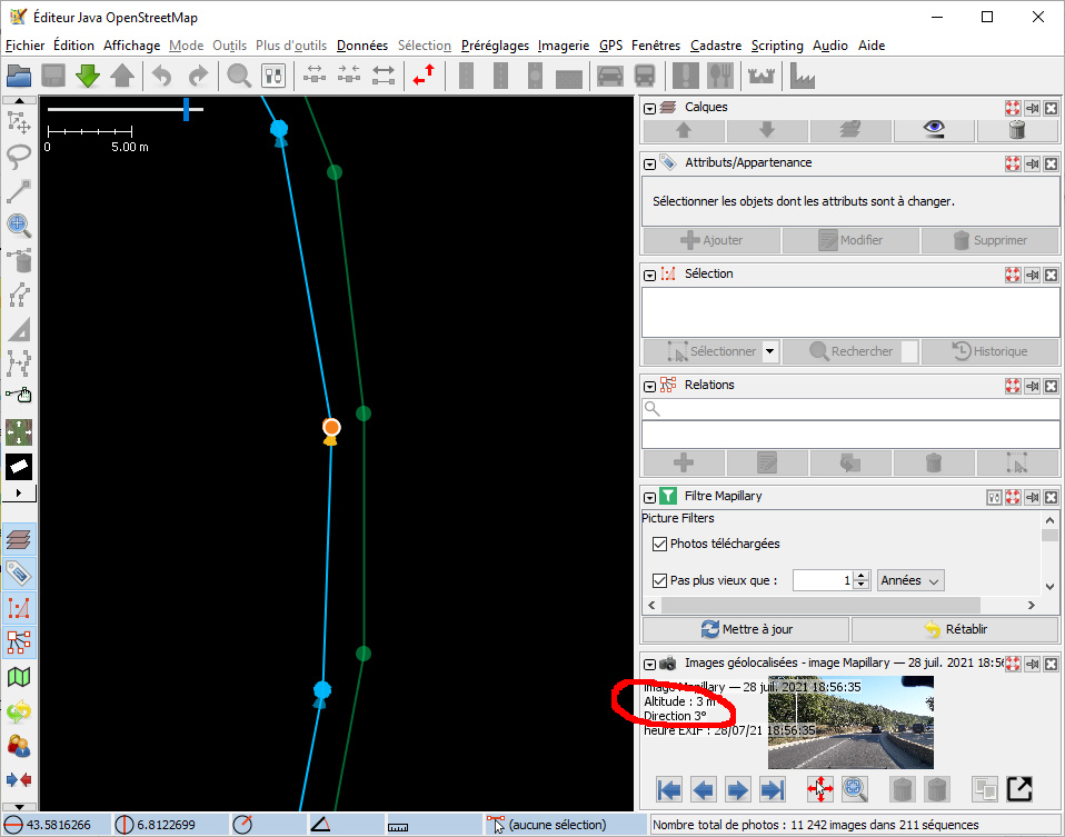
Altitude/elevation and direction displayed with the picture are wrong.
(Pictures were recorded with OpenCamera. Geolocalization were refined with JOSM using NMEA sequences from a F9P/Sparkfun RTK Express receiver with RTK corrections from a local CORS station. Pictures were uploaded using Mapillary Desktop Uploader.)
When I check locally pictures with GeoSetter app, I can see:
- direction : 182,58 °
- elevation : 158,9 m
which are both reasonable.
https://www.mapillary.com/app/?pKey=466666571842324.
This defect is not specific to my pictures.
For direction, is there a confusion between radian and °?
URL:https://josm.openstreetmap.de/svn/trunk
Repository:UUID: 0c6e7542-c601-0410-84e7-c038aed88b3b
Last:Changed Date: 2022-01-02 21:24:43 +0100 (Sun, 02 Jan 2022)
Build-Date:2022-01-02 20:26:19
Revision:18360
Relative:URL: ^/trunk

Identification: JOSM/1.5 (18360 fr) Windows 10 64-Bit
OS Build number: Windows 10 Home 2009 (19043)
Memory Usage: 581 MB / 989 MB (56 MB allocated, but free)
Java version: 1.8.0_321-b07, Oracle Corporation, Java HotSpot(TM) Client VM
Look and Feel: com.sun.java.swing.plaf.windows.WindowsLookAndFeel
Screen: \Display0 1920×1080 (scaling 1.00×1.00) \Display1 1280×1024 (scaling 1.00×1.00)
Maximum Screen Size: 1920×1080
Best cursor sizes: 16×16→32×32, 32×32→32×32
System property file.encoding: Cp1252
System property sun.jnu.encoding: Cp1252
Locale info: fr_FR
Numbers with default locale: 1234567890 -> 1234567890
Dataset consistency test: No problems found

Plugins:
+ DirectUpload (35893)
+ Mapillary (2.0.0-beta.2)
+ PicLayer (1.0.1)
+ apache-commons (35893)
+ apache-http (35893)
+ cadastre-fr (35893)
+ conflation (0.6.9)
+ ejml (35893)
+ geotools (35906)
+ jaxb (35893)
+ jna (35893)
+ jts (35893)
+ measurement (35893)
+ opendata (35899)
+ photo_geotagging (35893)
+ reverter (35893)
+ scripting (30798)
+ todo (30306)
+ utilsplugin2 (35893)
Attachments (1)
Change History (8)
by , 4 years ago
| Attachment: | josm_mapillary.jpg added |
|---|
comment:1 by , 4 years ago
Thank you for the bug report -- I've got a fix done for the direction (it was radians -> degrees).
I am actually tracking down an issue in the current master branch w.r.t. upside down images, so I don't know when I'll release that fix.
As far as elevation goes, it looks fine in my test area (1300-1400m). I'll check your image specifically. It might be a difference from computed altitude -> gps altitude.
follow-up: 3 comment:2 by , 4 years ago
The difference between GPS elevation and altitude should be around 50 m in my area.
I find the wrong elevation values for a lot of pictures, not only my ones:
https://www.mapillary.com/app/?pKey=313461796971945 (ele. above sea level should be 200 m). JOSM : 2 m.
https://www.mapillary.com/app/?pKey=1469665520036647 ~1300 m, JOSM 2 m.
In opposite, I find correct elevations in Moab(UT).
comment:3 by , 4 years ago
Replying to anonymous:
The difference between GPS elevation and altitude should be around 50 m in my area.
This appears to be a problem between computed_altitude and altitude. I'm probably going to add a sanity check for it.
comment:4 by , 4 years ago
| Resolution: | → fixed |
|---|---|
| Status: | new → closed |
I've got a fix I'll make available as soon as I figure out why some pictures are upside down. Which means I'll hopefully have a fix available today or tomorrow.
EDIT: And I've released the update. It should be available in ~10 minutes or so. You'll still need to update plugins.
comment:6 by , 4 years ago
Replying to Eric_S:
Successfully checked with JOSM March update.
Clarification: You updated JOSM and the plugins, and the problem reoccurred or did not reoccur. It should be the latter, but I figured I'd better double check.
Screen shot with Mapillary plugin