

Opened 5 years ago
Last modified 5 years ago
#21633 new defect
Add scroll bar to dialog "Automatic tag correction" — at Initial Version
| Reported by: | tomasmarklund | Owned by: | team |
|---|---|---|---|
| Priority: | normal | Milestone: | |
| Component: | Core | Version: | |
| Keywords: | template_report scroll bar dialog height | Cc: |
Description
What steps will reproduce the problem?
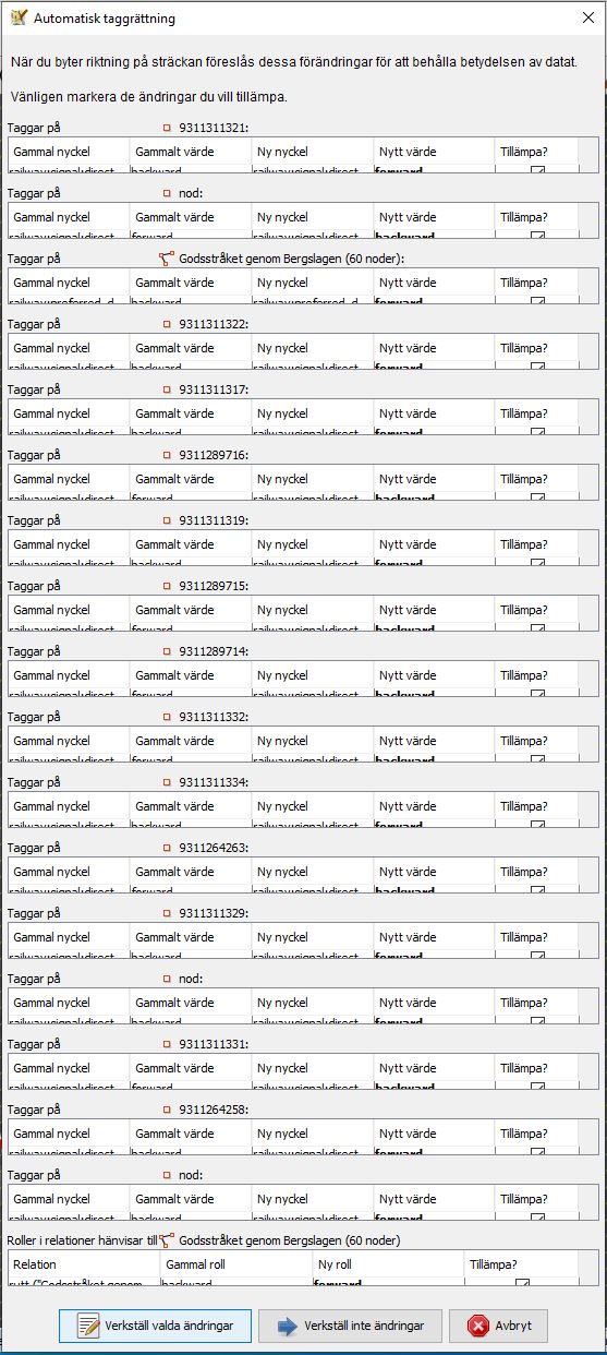
- Select a way which contains some direction dependent nodes (example: railway:signal:direction)
- reverse the direction of the way
- A dialog box "Automatic tag correction" appears saying "When reversing this way, the following changes are suggested in order to maintain data consistency."
What is the expected result?
All of the tags displayed should be visible in the dialog box
What happens instead?
For each tag, there is an imaginary "box" around the tags, which is scaled down to fit the dialog, which makes the individual tags dissapear outside the imaginary box.
A better way of solving this would to add a scroll bar to the whole dialog box, instead of shrinking the area available for each tag.
See enclosed screenshot, which is in swedish, but you can still se that the individual tags are at best barely visible.
Please provide any additional information below. Attach a screenshot if possible.
URL:https://josm.openstreetmap.de/svn/trunk
Repository:UUID: 0c6e7542-c601-0410-84e7-c038aed88b3b
Last:Changed Date: 2021-11-01 23:05:46 +0100 (Mon, 01 Nov 2021)
Build-Date:2021-11-01 22:25:18
Revision:18303
Relative:URL: ^/trunk

Identification: JOSM/1.5 (18303 sv) Windows 10 64-Bit
OS Build number: Windows 10 Home 2004 (19041)
Memory Usage: 935 MB / 935 MB (354 MB allocated, but free)
Java version: 1.8.0_311-b11, Oracle Corporation, Java HotSpot(TM) 64-Bit Server VM
Look and Feel: com.sun.java.swing.plaf.windows.WindowsLookAndFeel
Screen: \Display0 2560×1440 (scaling 1.00×1.00) \Display1 1920×1080 (scaling 1.00×1.00)
Maximum Screen Size: 2560×1440
Best cursor sizes: 16×16→32×32, 32×32→32×32
System property file.encoding: Cp1252
System property sun.jnu.encoding: Cp1252
Locale info: sv_SE
Numbers with default locale: 1234567890 -> 1234567890
VM arguments: [-Djava.security.manager, -Djnlp.application.href=https://josm.openstreetmap.de/download/josm.jnlp, -Djava.util.Arrays.useLegacyMergeSort=true, -Djnlp.tk=awt, -Djnlpx.jvm=<java.home>\bin\javaw.exe, -Djnlpx.splashport=65445, -Djnlpx.home=<java.home>\bin, -Djnlpx.remove=false, -Djnlpx.offline=false, -Djnlpx.relaunch=true, -Djnlpx.session.data=%UserProfile%\AppData\Local\Temp\session165682097984110924, -Djnlpx.heapsize=NULL,NULL, -Djava.security.policy=file:<java.home>\lib\security\javaws.policy, -DtrustProxy=true, -Djnlpx.origFilenameArg=%UserProfile%\AppData\LocalLow\Sun\Java\Deployment\cache\6.0\56\1ee8cfb8-39974266]
Dataset consistency test: No problems found

Plugins:
+ FastDraw (35640)
+ SeaMapEditor (35543)
+ apache-commons (35524)
+ areaselector (368)
+ austriaaddresshelper (1597341117)
+ buildings_tools (35823)
+ continuosDownload (99)
+ editgpx (35562)
+ ejml (35458)
+ geotools (35458)
+ jaxb (35543)
+ jts (35458)
+ log4j (35458)
+ measurement (35640)
+ opendata (35803)
+ reverter (35732)
+ scripting (30798)
+ utilsplugin2 (35842)

Tagging presets:
+ https://raw.githubusercontent.com/yopaseopor/traffic_signs_preset_JOSM/master/SE.zip
+ https://raw.githubusercontent.com/OpenNauticalChart/josm/master/INT-1-preset.xml

Map paint styles:
+ https://raw.githubusercontent.com/OpenSeaMap/josm/master/INT1_Seamark.mapcss

Last errors/warnings:
- 00365.612 W: Unable to find supported projection for layer Lantmäteriet ortofoto. Using EPSG:3857.
- 00365.615 W: Unable to find supported projection for layer Lantmäteriet ortofoto. Using EPSG:3857.
Note:
See TracTickets
for help on using tickets.