

#20565 closed defect (fixed)
WMS get layers doesnt't resolve fully (but does in QGIS and Vespucci)
| Reported by: | TrekClimbing | Owned by: | team |
|---|---|---|---|
| Priority: | normal | Milestone: | 21.02 |
| Component: | Core imagery | Version: | tested |
| Keywords: | template_report | Cc: |
Description
What steps will reproduce the problem?
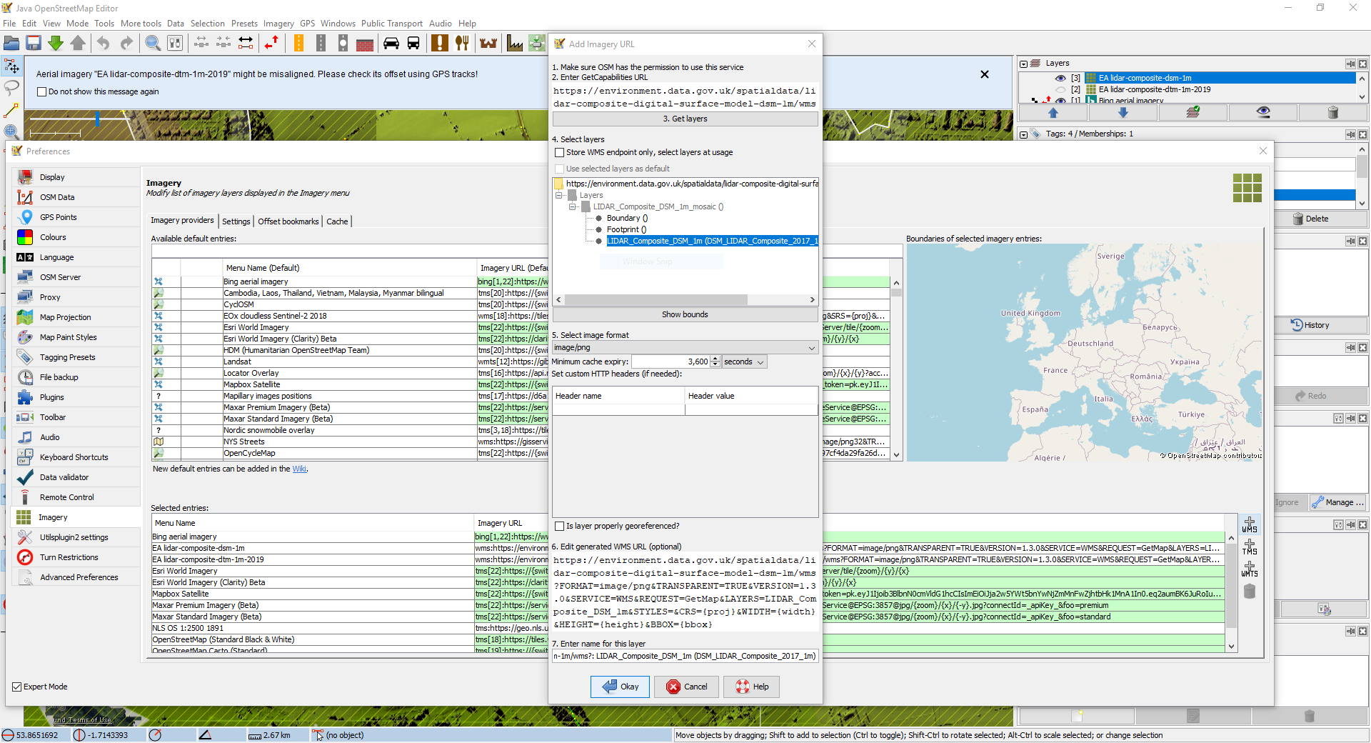
- Open imagery preferences
- Click +WMS and enter https://environment.data.gov.uk/spatialdata/lidar-composite-digital-terrain-model-dtm-1m-2019/wms
- Click Get layers and select the LIDAR Composite DTM 1m 2019 layer
What is the expected result?
A URL that works is generated (including projection as EPSG:3857) i.e. wms:https://environment.data.gov.uk/spatialdata/lidar-composite-digital-terrain-model-dtm-1m-2019/wms?FORMAT=image/png&TRANSPARENT=TRUE&VERSION=1.3.0&SERVICE=WMS&REQUEST=GetMap&LAYERS=1&STYLES=&CRS=EPSG:3857&WIDTH={width}&HEIGHT={height}&BBOX={bbox}
What happens instead?
The provided URL is wms:https://environment.data.gov.uk/spatialdata/lidar-composite-digital-terrain-model-dtm-1m-2019/wms?FORMAT=image/png&TRANSPARENT=TRUE&VERSION=1.3.0&SERVICE=WMS&REQUEST=GetMap&LAYERS=1&STYLES=&CRS={proj}&WIDTH={width}&HEIGHT={height}&BBOX={bbox}
Please provide any additional information below. Attach a screenshot if possible.
Same for https://environment.data.gov.uk/spatialdata/lidar-composite-digital-surface-model-dsm-1m/wms except this time the projection should be EPSG:4326. i.e.
wms:https://environment.data.gov.uk/spatialdata/lidar-composite-digital-surface-model-dsm-1m/wms?FORMAT=image/png&TRANSPARENT=TRUE&VERSION=1.3.0&SERVICE=WMS&REQUEST=GetMap&LAYERS=LIDAR_Composite_DSM_1m&STYLES=&CRS=EPSG:4326&WIDTH={width}&HEIGHT={height}&BBOX={bbox}
I'm not sure why this is - Rob Nickerson on talk-GB said the layer is not reporting its available projections properly. However, it works in QGIS and Vespucci.
URL:https://josm.openstreetmap.de/svn/trunk
Repository:UUID: 0c6e7542-c601-0410-84e7-c038aed88b3b
Last:Changed Date: 2020-12-28 22:03:23 +0100 (Mon, 28 Dec 2020)
Build-Date:2020-12-29 02:30:53
Revision:17428
Relative:URL: ^/trunk

Identification: JOSM/1.5 (17428 en_GB) Windows 10 64-Bit
OS Build number: Windows 10 Home 1909 (18363)
Memory Usage: 1852 MB / 1852 MB (638 MB allocated, but free)
Java version: 1.8.0_271-b09, Oracle Corporation, Java HotSpot(TM) 64-Bit Server VM
Look and Feel: com.sun.java.swing.plaf.windows.WindowsLookAndFeel
Screen: \Display0 1920×1080 (scaling 1.00×1.00)
Maximum Screen Size: 1920×1080
Best cursor sizes: 16×16→32×32, 32×32→32×32
Dataset consistency test: No problems found

Plugins:
+ DirectUpload (35640)
+ Lanes (1609563498)
+ apache-commons (35524)
+ buildings_tools (35669)
+ imagery_offset_db (35640)
+ photo_geotagging (35640)
+ photoadjust (35640)
+ public_transport (35640)
+ terracer (35640)
+ turnrestrictions (35640)
+ utilsplugin2 (35691)

Tagging presets:
+ https://josm.openstreetmap.de/josmfile?page=Presets/EnglandWalesRightsOfWay&zip=1

Map paint styles:
- https://josm.openstreetmap.de/josmfile?page=Styles/PublicTransport&zip=1
- https://josm.openstreetmap.de/josmfile?page=Styles/Lane_and_Road_Attributes&zip=1

Last errors/warnings:
- 00423.092 W: Unable to find supported projection for layer EA lidar-composite-dtm-1m-2019. Using EPSG:3857.
- 00423.093 W: Unable to find supported projection for layer EA lidar-composite-dtm-1m-2019. Using EPSG:3857.
Attachments (2)
Change History (12)
by , 5 years ago
| Attachment: | Screenshot_20210304-223202_Vespucci.jpg added |
|---|
by , 5 years ago
| Attachment: | WMS-Get-layers-problem.PNG added |
|---|
comment:1 by , 5 years ago
| Component: | Core → Core imagery |
|---|
comment:3 by , 5 years ago
| Milestone: | → 21.02 |
|---|
I can add this layer (on latest version) either:
- saving it as endpoint (checking the box "store wms endpoint only")
- taking care to choose the layer with black text
Using either way, I got working layer. The bug that I've fixed is the one, that allows adding the layer although invalid selection is made.
Though on the screenshot provided, correct selection is made.
And referring to expected result:
- JOSM will not store projection in template URL, as projection is chosen at runtime depending on what server supports
- This layers doesn't support EPSG:3857 so expected result is wrong anyway ;-)
follow-up: 5 comment:4 by , 5 years ago
@wiktorn:
Such behavior breaks some WMS-es. There are some municipal geoportals which use non-standard URL format that don't return GetCapabilities.
There should be some way of overriding this.
follow-up: 7 comment:5 by , 5 years ago
Replying to RicoElectrico:
@wiktorn:
Such behavior breaks some WMS-es. There are some municipal geoportals which use non-standard URL format that don't return GetCapabilities.
There should be some way of overriding this.
Rico,
Can you elaborate more about "such behavior"? Do you mean the change I've introduced, or the fact that if you add imagery entry by hand you don't have the ability (in GUI) to set which projections are supported by the server?
Can you name such servers?
BTW: supporting GetCapabilities is mandatory in both WMS 1.1.1 and 1.3.0 so if this is the case, these must be really bad implementation.
comment:6 by , 5 years ago
Btw. the field "6. Edit generated WMS URL (Optional)" doesn't work as it should. Any change made there is discarded in generated url after pressing OK. Is this somehow related to the fix for this issue or unrelated bug?
follow-up: 8 comment:7 by , 5 years ago
Replying to wiktorn:
Replying to RicoElectrico:
@wiktorn:
Such behavior breaks some WMS-es. There are some municipal geoportals which use non-standard URL format that don't return GetCapabilities.
There should be some way of overriding this.
Rico,
Can you elaborate more about "such behavior"? Do you mean the change I've introduced, or the fact that if you add imagery entry by hand you don't have the ability (in GUI) to set which projections are supported by the server?
It is not possible to paste any WMS URL template into field 6. without going through GetCapabilities first. I don't really mind trying the projections manually afterwards, actually I'd know projection from the URL that I edited to make a template.
Can you name such servers?
Geoportals made with WebEWID. And probably many others that we have available in the imagery database, you'd have to check which seems feasible with a little script ;)
For example, cadastral map of Gdynia:
BTW: supporting GetCapabilities is mandatory in both WMS 1.1.1 and 1.3.0 so if this is the case, these must be really bad implementation.
If there's only one client typically in use, they don't care I guess.
follow-up: 10 comment:8 by , 5 years ago
Replying to RicoElectrico:
It is not possible to paste any WMS URL template into field 6. without going through GetCapabilities first. I don't really mind trying the projections manually afterwards, actually I'd know projection from the URL that I edited to make a template.
It's separate issue from this one and I'm pretty sure, that fix here shouldn't change this behaviour. I'll take look on this.
comment:10 by , 5 years ago
Replying to RicoElectrico:
It is not possible to paste any WMS URL template into field 6. without going through GetCapabilities first. I don't really mind trying the projections manually afterwards, actually I'd know projection from the URL that I edited to make a template.
I've added support for that. I couldn't verify if the imagery you've provided works properly, as it returned only transparent tiles.
Not adding a working URL on JOSM