

#19848 closed defect (fixed)
Could not get the latest orthophoto map for Poland
| Reported by: | anonymous | Owned by: | team |
|---|---|---|---|
| Priority: | normal | Milestone: | |
| Component: | External imagery source | Version: | latest |
| Keywords: | WMTS WMS poland | Cc: | wiktorn |
Description (last modified by )
What steps will reproduce the problem?
- Try to add a new WMTS or WMS map like:
Or:
It works for the old map:
https://mapy.geoportal.gov.pl/wss/service/WMTS/guest/wmts/ORTO?SERVICE=WMTS&REQUEST=GetCapabilities
What is the expected result?
A new layer added
What happens instead?
I get an error see attached picture

Please provide any additional information below. Attach a screenshot if possible.
URL:https://josm.openstreetmap.de/svn/trunk Repository:UUID: 0c6e7542-c601-0410-84e7-c038aed88b3b Last:Changed Date: 2020-09-06 16:54:59 +0200 (Sun, 06 Sep 2020) Build-Date:2020-09-07 01:30:48 Revision:17013 Relative:URL: ^/trunk Identification: JOSM/1.5 (17013 pl) Windows 10 64-Bit OS Build number: Windows 10 Education 2004 (19041) Memory Usage: 1153 MB / 1820 MB (211 MB allocated, but free) Java version: 1.8.0_261-b12, Oracle Corporation, Java HotSpot(TM) 64-Bit Server VM Look and Feel: com.sun.java.swing.plaf.windows.WindowsLookAndFeel Screen: \Display0 1920x1080 (scaling 1.0x1.0) Maximum Screen Size: 1920x1080 Best cursor sizes: 16x16 -> 32x32, 32x32 -> 32x32 VM arguments: [-Djava.security.manager, -Djava.security.policy=file:<java.home>\lib\security\javaws.policy, -DtrustProxy=true, -Djnlpx.home=<java.home>\bin, -Djnlpx.origFilenameArg=%UserProfile%\Downloads\josm.jnlp, -Djnlpx.remove=false, -Djava.util.Arrays.useLegacyMergeSort=true, -Djnlpx.heapsize=NULL,2048m, -Djnlpx.splashport=56911, -Djnlpx.jvm=<java.home>\bin\javaw.exe] Dataset consistency test: No problems found Plugins: + PicLayer (35405) + indoorhelper (20bf8a3-dirty) Map paint styles: - <josm.pref>\styles\sit.mapcss Last errors/warnings: - 00011,931 W: Uaktualnij wtyczki - Uaktualniono program JOSM. Aby zapobiec błędom wtyczki również - 00053,794 E: Region [TMS_BLOCK_v2] : Problem loading keys for file TMS_BLOCK_v2 - 00092,111 E: java.lang.ClassNotFoundException: controller.IndoorHelperController - 00165,159 E: Region [WMS_BLOCK_v2] : Problem loading keys for file WMS_BLOCK_v2 - 00399,080 E: Could not parse WMS layer list. Incoming data: - 00411,410 E: Could not parse WMS layer list. Incoming data: - 00948,188 E: Could not parse WMS layer list. Incoming data:
Attachments (2)
Change History (9)
by , 6 years ago
| Attachment: | WMTS error.png added |
|---|
comment:1 by , 6 years ago
| Component: | Core → Core imagery |
|---|
comment:2 by , 6 years ago
| Cc: | added |
|---|---|
| Description: | modified (diff) |
| Keywords: | poland added; and removed |
comment:3 by , 6 years ago
| Resolution: | → othersoftware |
|---|---|
| Status: | new → closed |
The error message says that it couldn't read the data. This is known problem of this tile server. See:
$ curl -v -o /dev/null -H 'User-Agent: Java' 'https://mapy.geoportal.gov.pl/wss/service/PZGIK/ORTO/WMTS/HighResolution?SERVICE=WMTS&REQUEST=GetCapabilities'
[... SSL stuff ...]
> GET /wss/service/PZGIK/ORTO/WMTS/HighResolution?SERVICE=WMTS&REQUEST=GetCapabilities HTTP/1.1
> Host: mapy.geoportal.gov.pl
> Accept: */*
> User-Agent: Java
>
{ [5 bytes data]
* Mark bundle as not supporting multiuse
* HTTP 1.0, assume close after body
< HTTP/1.0 200 OK
* HTTP/1.0 connection set to keep alive!
< Connection: Keep-Alive
< Content-Length: 0
<
They "ban" any user agent containing Java. If I send:
$ curl -v -o /dev/null 'https://mapy.geoportal.gov.pl/wss/service/PZGIK/ORTO/WMTS/HighResolution?SERVICE=WMTS&REQUEST=GetCapabilities'
* Mark bundle as not supporting multiuse
< HTTP/1.1 200 OK
< Access-Control-Allow-Origin: *
< app-name: iMapServer
< Content-Type: text/xml;charset=UTF-8
< Date: Thu, 01 Oct 2020 20:12:40 GMT
< Content-Length: 38050
< Set-Cookie: BIGipServercs-sb-ogc-prem-8081=!VvEBsl0PQXaS/GJb8D3N7RVONEMPZ57FxuwjA1P9xegvN/8hQoygk+7sbFdMp3uLGiJ5t0WGAqauF+k=; path=/; Httponly; Secure
< Vary: Accept-Encoding
<
{ [16038 bytes data]
100 38050  100 38050    0     0  91247      0 --:--:-- --:--:-- --:--:-- 91247
Please note the difference in Content-Length.
As for the reporting user, they may enable expert mode and provide custom user-agent header in this case.
The other approach is to add HighResolution layers to the imagery list, with custom headers.
comment:4 by , 6 years ago
| Resolution: | othersoftware → fixed |
|---|
Added to the list in https://josm.openstreetmap.de/wiki/Maps/Poland?action=diff&version=163
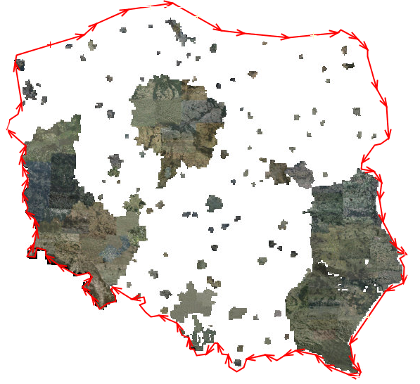
Note that it is not available for the whole country:

comment:5 by , 6 years ago
| Component: | Core imagery → External imagery source |
|---|
by , 6 years ago
| Attachment: | 19848a.PNG added |
|---|
follow-up: 7 comment:6 by , 6 years ago
Wouldn't the note better go into the description instead of the HTML comment?
comment:7 by , 6 years ago
Replying to stoecker:
Wouldn't the note better go into the description instead of the HTML comment?
Yes, done.
Even better would be a proper shape, but
- I don't know if this changes frequently
- I'm too lazy to draw that by hand
What would massively help with the shapes would be if we could find a setting e.g. in Tracer 2 to create the shapes semi automatic on low zoom.
@Wiktor, what does the translated error messages say?