

Opened 6 years ago
Closed 6 years ago
#19781 closed enhancement (wontfix)
Customizable width and opacity of area outline
| Reported by: | Famlam | Owned by: | team |
|---|---|---|---|
| Priority: | normal | Milestone: | |
| Component: | Internal mappaint style | Version: | tested |
| Keywords: | template_report outline area width opacity | Cc: |
Description (last modified by )
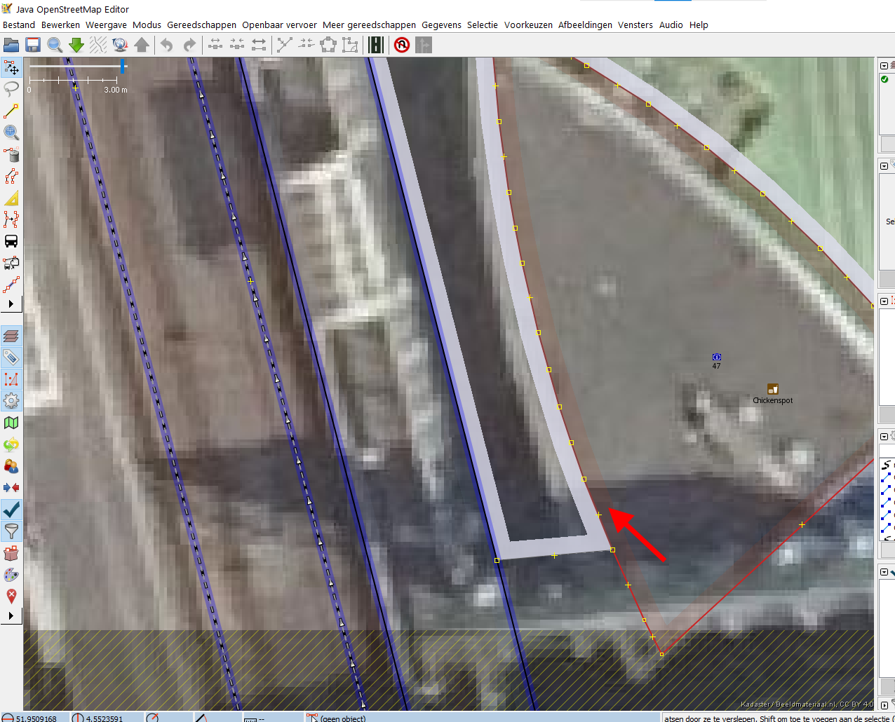
See attached image. At almost all zoom levels where you still have an overview of the general building and town square outline, the actual edge of the building/pedestrian area is partially covered by the ~5mm almost-non-transparant outline of the pedestrian area.
It would be great if either the opacity (transparancy?) of the broad outline, or the width of the outline (now ~5mm) could be customized
Position: https://www.openstreetmap.org/#map=19/51.95095/4.55236
URL:https://josm.openstreetmap.de/svn/trunk
Repository:UUID: 0c6e7542-c601-0410-84e7-c038aed88b3b
Last:Changed Date: 2020-09-06 16:54:59 +0200 (Sun, 06 Sep 2020)
Build-Date:2020-09-07 01:30:48
Revision:17013
Relative:URL: ^/trunk

Identification: JOSM/1.5 (17013 nl) Windows 10 64-Bit
OS Build number: Windows 10 Home 2004 (19041)
Memory Usage: 969 MB / 1820 MB (338 MB allocated, but free)
Java version: 1.8.0_261-b12, Oracle Corporation, Java HotSpot(TM) 64-Bit Server VM
Look and Feel: com.sun.java.swing.plaf.windows.WindowsLookAndFeel
Screen: \Display0 1920x1080 (scaling 1.0x1.0)
Maximum Screen Size: 1920x1080
Best cursor sizes: 16x16 -> 32x32, 32x32 -> 32x32
Dataset consistency test: No problems found

Plugins:
+ OpeningHoursEditor (35414)
+ imagery_offset_db (35405)
+ pt_assistant (2.1.10-80-g7d9bba3)
+ tageditor (35258)
+ turnlanes-tagging (283)
+ undelete (35521)
+ utilsplugin2 (35487)

Map paint styles:
- https://josm.openstreetmap.de/josmfile?page=Styles/Lane_and_Road_Attributes&zip=1
- https://josm.openstreetmap.de/josmfile?page=Styles/PublicTransport&zip=1

Validator rules:
+ %UserProfile%\Documents\tijdelijke bestanden\josm-eigen.validator.mapcss

Last errors/warnings:
- 00043,422 W: java.net.SocketTimeoutException: Read timed out. Oorzaak: java.net.SocketTimeoutException: Read timed out
- 00044,187 W: java.net.SocketTimeoutException: Read timed out. Oorzaak: java.net.SocketTimeoutException: Read timed out

Attachments (3)
Change History (11)
by , 6 years ago
| Attachment: | Outline.png added |
|---|
comment:1 by , 6 years ago
| Description: | modified (diff) |
|---|
comment:2 by , 6 years ago
| Description: | modified (diff) |
|---|
comment:3 by , 6 years ago
| Description: | modified (diff) |
|---|
by , 6 years ago
| Attachment: | 19781a.PNG added |
|---|
comment:4 by , 6 years ago
| Owner: | changed from to |
|---|---|
| Status: | new → needinfo |
by , 6 years ago
| Attachment: | Mappaintstyles.png added |
|---|
Surprisingly, the ones listed in the report are the disabled ones only? Anyway, I have the default and Potlach enabled (see image)
comment:5 by , 6 years ago
| Component: | Core mappaint → Internal mappaint style |
|---|---|
| Owner: | changed from to |
| Status: | needinfo → new |
comment:6 by , 6 years ago
Surprisingly, the ones listed in the report are the disabled ones only?
The internal ones are not listed in the statusreport.
comment:7 by , 6 years ago
Perhaps the following is relevant? mappaint.fillalpha=20 doesn't help (so probably this isn't considered a "fill")
URL:https://josm.openstreetmap.de/svn/trunk
Repository:UUID: 0c6e7542-c601-0410-84e7-c038aed88b3b
Last:Changed Date: 2020-09-06 16:54:59 +0200 (Sun, 06 Sep 2020)
Build-Date:2020-09-07 01:30:48
Revision:17013
Relative:URL: ^/trunk

Identification: JOSM/1.5 (17013 nl) Windows 10 64-Bit
OS Build number: Windows 10 Home 2004 (19041)
Memory Usage: 931 MB / 1820 MB (558 MB allocated, but free)
Java version: 1.8.0_261-b12, Oracle Corporation, Java HotSpot(TM) 64-Bit Server VM
Look and Feel: com.sun.java.swing.plaf.windows.WindowsLookAndFeel
Screen: \Display0 1920x1080 (scaling 1.0x1.0)
Maximum Screen Size: 1920x1080
Best cursor sizes: 16x16 -> 32x32, 32x32 -> 32x32

Plugins:
+ OpeningHoursEditor (35414)
+ imagery_offset_db (35405)
+ pt_assistant (2.1.10-80-g7d9bba3)
+ tageditor (35258)
+ turnlanes-tagging (283)
+ undelete (35521)
+ utilsplugin2 (35487)

Map paint styles:
- https://josm.openstreetmap.de/josmfile?page=Styles/Lane_and_Road_Attributes&zip=1
- https://josm.openstreetmap.de/josmfile?page=Styles/PublicTransport&zip=1

Validator rules:
+ %UserProfile%\Documents\tijdelijke bestanden\josm-eigen.validator.mapcss

Last errors/warnings:
- 00054,332 W: java.net.SocketTimeoutException: Read timed out

autosave.enabled=false
cache.bing.attribution.xml=1598998814
cache.capabilities1637351842=1599481014
cache.motd.html=1599823516
cache.motd.html.java=1.8.0_261
cache.motd.html.lang=Nl:
cache.motd.html.version=17013
changeset.lastHeight=242
changesetdialog.lastHeight=0
commandstack.lastHeight=0
conflict.lastHeight=0
conflict.minimized=true
coordinates=DECIMAL_DEGREES
download.autorun=true
download.osm.notes=true
download.overpass.servers=[http://overpass.openstreetmap.ru/cgi/, https://overpass-api.de/api/]
downloadAlongWay.area=1.0
downloadAlongWay.distance=15.0
downloadprimitive.lasttype=1
draw.rawgps.colormode=0
draw.rawgps.lines=2
expert=true
filter.lastHeight=20
filter.minimized=true
filter.visible=true
filters.entries=[{version=1, text=location=underground OR tunnel=*, mode=add, enable=false, hiding=true, inverted=false}, {version=1, text=railway=*, mode=add, enable=false, hiding=true, inverted=false}, {version=1, text=landuse=industrial, mode=add, enable=false, hiding=true, inverted=false}, {version=1, text=landuse=railway, mode=add, enable=false, hiding=true, inverted=false}, {version=1, text=landuse=commercial, mode=add, enable=false, hiding=true, inverted=false}]
gui.geometry=x=-8,y=-8,width=1936,height=1053
gui.maximized=true
gui.start.animation=false
imagery.entries=[{transparent=true, minimumTileExpire=3600, name=BGT omtrekgericht, type=wmts, url=https://geodata.nationaalgeoregister.nl/tiles/service/wmts?request=GetCapabilities&service=WMTS, cookies=, default-layers=[{"layerName":"bgtomtrekgericht","style":"","tileMatrixSet":"EPSG:28992:16"}], customHttpHeaders={}},
  {max-zoom=22, min-zoom=1, noTileHeaders={"X-VE-Tile-Info":["no-tile"]}, noTileChecksums={"MD5":["c13269481c73de6e18589f9fbc3bdf7e"]}, metadataHeaders={"X-VE-TILEMETA-CaptureDatesRange":"Capture Date"}, transparent=true, minimumTileExpire=3600, name=Bing luchtfotografie, id=Bing, type=bing, url=https://www.bing.com/maps/, permission-reference-url=https://wiki.openstreetmap.org/wiki/Bing_Maps, cookies=, icon=data:image/png;base64,iVBORw0..., customHttpHeaders={}, category=photo},
  {max-zoom=22, noTileHeaders={"Etag":["\"10i954m13i2\""]}, noTileChecksums={"MD5":["f27d9de7f80c13501f470595e327aa6d"]}, transparent=true, minimumTileExpire=3600, name=Esri World Imagery, id=EsriWorldImagery, type=tms, url=https://{switch:services,server}.arcgisonline.com/arcgis/rest/services/World_Imagery/MapServer/tile/{zoom}/{y}/{x}, attribution-text=Terms & Feedback, attribution-url=https://wiki.openstreetmap.org/wiki/Esri, cookies=, icon=data:image/png;base64,iVBORw0..., customHttpHeaders={}, category=photo},
  {max-zoom=22, transparent=true, minimumTileExpire=3600, name=Esri World Imagery (Clarity) Beta, id=EsriWorldImageryClarity, type=tms, url=https://clarity.maptiles.arcgis.com/arcgis/rest/services/World_Imagery/MapServer/tile/{zoom}/{y}/{x}, attribution-text=Terms & Feedback, attribution-url=https://wiki.openstreetmap.org/wiki/Esri, permission-reference-url=https://github.com/osmlab/editor-layer-index/pull/358#issuecomment-361416110, cookies=, icon=data:image/png;base64,iVBORw0..., description=Esri archiefafbeeldingen die helderder en meer nauwkeuriger zouden kunnen zijn dan de standaardlaag., customHttpHeaders={}, category=photo},
  {max-zoom=22, noTileHeaders={"ETag":["\"067736a547cafe90014b4e59b6510abe\"|\"ee1f6802b0234046b553cbbc672ac7d9\"|\"9f5a2f1d7cc131e58befc2052c71c827\""]}, noTileChecksums={"MD5":["811bb5f56a0e672f674a2a820d340c61"]}, transparent=true, minimumTileExpire=3600, name=Mapbox Satellite, id=Mapbox, type=tms, url=https://{switch:a,b,c,d}.tiles.mapbox.com/v4/mapbox.satellite/{zoom}/{x}/{y}.jpg?access_token=pk.eyJ1Ijoib3BlbnN0cmVldG1hcCIsImEiOiJjaml5MjVyb3MwMWV0M3hxYmUzdGdwbzE4In0.q548FjhsSJzvXsGlPsFxAQ, attribution-text=Terms & Feedback, attribution-url=https://www.mapbox.com/about/maps/, permission-reference-url=https://wiki.openstreetmap.org/wiki/Vertical_Aerial_Photographs#DigitalGlobe_.2F_MapBox, cookies=, icon=data:image/png;base64,iVBORw0..., customHttpHeaders={}, category=photo},
  {max-zoom=22, valid-georeference=true, transparent=true, minimumTileExpire=3600, name=Maxar Premium afbeeldingen (Bèta), id=Maxar-Premium, type=tms, url=https://services.digitalglobe.com/earthservice/tmsaccess/tms/1.0.0/DigitalGlobe:ImageryTileService@EPSG:3857@jpg/{zoom}/{x}/{-y}.jpg?connectId=_apiKey_&foo=premium, attribution-text=Terms & Feedback, attribution-url=https://wiki.openstreetmap.org/wiki/DigitalGlobe, cookies=, icon=data:image/png;base64,iVBORw0..., description=Maxar Premium is een mozaïek, samengesteld uit de Maxar basiskaart met geselecteerde regio's gevuld met +Vivid of afbeeldingen van aangepast gebied van interesse, 50cm resolutie of beter, en meer frequent ververst met doorlopende updates., customHttpHeaders={}, category=photo},
  {max-zoom=18, valid-georeference=true, modTileFeatures=true, transparent=true, minimumTileExpire=3600, name=OpenStreetMap (Standaard zwart & wit), id=osm-mapnik-black_and_white, type=tms, url=https://tiles.wmflabs.org/bw-mapnik/{zoom}/{x}/{y}.png, attribution-text=© OpenStreetMap contributors, CC-BY-SA, attribution-url=https://www.openstreetmap.org/, cookies=, icon=data:image/png;base64,iVBORw0..., customHttpHeaders={}, category=osmbasedmap},
  {max-zoom=19, valid-georeference=true, modTileFeatures=true, transparent=true, minimumTileExpire=3600, name=OpenStreetMap Carto (Standaard), id=standard, type=tms, url=https://{switch:a,b,c}.tile.openstreetmap.org/{zoom}/{x}/{y}.png, attribution-text=© OpenStreetMap contributors, attribution-url=https://www.openstreetmap.org/, permission-reference-url=https://wiki.osmfoundation.org/wiki/Terms_of_Use, cookies=, icon=data:image/png;base64,iVBORw0..., customHttpHeaders={}, category=osmbasedmap},
  {transparent=true, minimumTileExpire=3600, name=PDOK Luchtfoto actueel IR, type=wms, url=https://geodata.nationaalgeoregister.nl/luchtfoto/infrarood/wms?FORMAT=image/jpeg&VERSION=1.1.1&SERVICE=WMS&REQUEST=GetMap&LAYERS=Actueel_ortho25IR&STYLES=&SRS={proj}&WIDTH={width}&HEIGHT={height}&BBOX={bbox}, cookies=, customHttpHeaders={}}
]
imagery.layers.default=[Bing, EsriWorldImagery, EsriWorldImageryClarity, Mapbox, Maxar-Premium, Maxar-Standard, osm-mapnik-black_and_white, standard]
imagery.offsetbookmarks=[]
iodb.modify.toolbar=false
josm.version=17013
lastDirectory=%UserProfile%\Desktop
layerlist.lastHeight=138
mappaint.fillalpha=20
mappaint.renderer-class-name=org.openstreetmap.josm.data.osm.visitor.paint.StyledMapRenderer
mappaint.style.entries=[{active=true, title=JOSM standaard (MapCSS), ptoken=standard, url=resource://styles/standard/elemstyles.mapcss}, {active=true, title=Potlatch 2, ptoken=standard, url=resource://styles/standard/potlatch2.mapcss}, {active=false, title=Lane and road attributes, url=https://josm.openstreetmap.de/josmfile?page=Styles/Lane_and_Road_Attributes&zip=1}, {active=false, title=Public Transport, url=https://josm.openstreetmap.de/josmfile?page=Styles/PublicTransport&zip=1}]
mappaint.style.known-defaults=[resource://styles/standard/elemstyles.mapcss, resource://styles/standard/potlatch2.mapcss]
mapstyle.lastHeight=0
menu.always-visible=false
message.imagery.nagPanel.https://geodata.nationaalgeoregister.nl/luchtfoto/infrarood/wms?FORMAT=image/jpeg&VERSION=1.1.1&SERVICE=WMS&REQUEST=GetMap&LAYERS=Actueel_ortho25IR&STYLES=&SRS={proj}&WIDTH={width}&HEIGHT={height}&BBOX={bbox}=false
message.imagery.nagPanel.https://geodata.nationaalgeoregister.nl/tiles/service/wmts?request=GetCapabilities&service=WMTS=false
minimap.lastHeight=0
mirror.https://geodata.nationaalgeoregister.nl/luchtfoto/infrarood/wms?request_GetCapabilities=[1578850628378, <josm.cache>\mirror_https___geodata.nationaalgeoregister.nl_luchtfoto_infrarood_wms_request_GetCapabilities]
mirror.https://geodata.nationaalgeoregister.nl/luchtfoto/rgb/wmts?request_GetCapabilities=[1578248252414, <josm.cache>\mirror_https___geodata.nationaalgeoregister.nl_luchtfoto_rgb_wmts_request_GetCapabilities]
mirror.https://geodata.nationaalgeoregister.nl/tiles/service/wmts?request_GetCapabilities&service_WMTS=[1599823602053, <josm.cache>\mirror_https___geodata.nationaalgeoregister.nl_tiles_service_wmts_request_GetCapabilities_service_WMTS]
mirror.https://josm.openstreetmap.de/josmfile?page_Rules/KeepRight&zip_1=[1595622452205, <josm.cache>\mirror_https___josm.openstreetmap.de_josmfile_page_Rules_KeepRight_zip_1]
mirror.https://josm.openstreetmap.de/josmfile?page_Styles/Lane_and_Road_Attributes&zip_1=[1599481015313, <josm.cache>\mirror_https___josm.openstreetmap.de_josmfile_page_Styles_Lane_and_Road_Attributes_zip_1]
mirror.https://josm.openstreetmap.de/josmfile?page_Styles/PublicTransport&zip_1=[1599481015376, <josm.cache>\mirror_https___josm.openstreetmap.de_josmfile_page_Styles_PublicTransport_zip_1]
mirror.https://josm.openstreetmap.de/maps=[1599823518078, <josm.cache>\mirror_https___josm.openstreetmap.de_maps]
mirror.https://josm.openstreetmap.de/presets=[1599836256496, <josm.cache>\mirror_https___josm.openstreetmap.de_presets]
mirror.https://josm.openstreetmap.de/remote/geofabrik-index-v1-nogeom.json=[1599481015547, <josm.cache>\mirror_https___josm.openstreetmap.de_remote_geofabrik-index-v1-nogeom.json]
mirror.https://josm.openstreetmap.de/remote/sophox-sparql?query_SELECT+%28CONCAT%28%22Key%3A%22%2C+%3Fpermanent_key_ID%29+as+%3FOSM_key%29+%3Fformatter_URL+WHERE+%7B%0A++%3Fitem+osmdt%3AP2+osmd%3AQ7.%0A++%3Fitem+osmdt%3AP16+%3Fpermanent_key_ID.%0A++%3Fitem+osmdt%3AP8+%3Fformatter_URL.%0A%7D%0A=[1591046349183, <josm.cache>\mirror_https___josm.openstreetmaa9afd68cc62ad3780ff2609e7bb1e11b]
mirror.https://josm.openstreetmap.de/remote/wikidata-sparql?query_SELECT+%3FOSM_key+%3Fformatter_URL+WHERE+%7B%0A++%7B+%3Fitem+wdt%3AP1282+%3FOSM_key.+%7D%0A++FILTER%28STRSTARTS%28%3FOSM_key%2C+%27Key%3A%27%29%29+.%0A%0A++%7B%0A++++%7B+%3Fitem+wdt%3AP1630+%3Fformatter_URL.+%7D%0A++++UNION%0A++++%7B+%3Fitem+wdt%3AP3303+%3Fformatter_URL.+%7D%0A++%7D%0A%7D%0A=[1591046348863, <josm.cache>\mirror_https___josm.openstreetma2ed2f87d98ef5b24c7f8123020996ecf]
mirror.https://josm.openstreetmap.de/rules=[1597741136599, <josm.cache>\mirror_https___josm.openstreetmap.de_rules]
mirror.https://josm.openstreetmap.de/styles=[1599836249295, <josm.cache>\mirror_https___josm.openstreetmap.de_styles]
mirror.https://josm.openstreetmap.de/tested=[1599572183601, <josm.cache>\mirror_https___josm.openstreetmap.de_tested]
mirror.https://josm.openstreetmap.de/wiki/Plugin/PT_Assistant/Wizard?format_txt=[1572986605154, <josm.cache>\mirror_https___josm.openstreetmap.de_wiki_Plugin_PT_Assistant_Wizard_format_txt]
mirror.https://query.wikidata.org/sparql?query_SELECT+%3FOSM_key+%3Fformatter_URL+WHERE+%7B%0A++%7B+%3Fitem+wdt%3AP1282+%3FOSM_key.+%7D%0A++FILTER%28STRSTARTS%28%3FOSM_key%2C+%27Key%3A%27%29%29+.%0A%0A++%7B%0A++++%7B+%3Fitem+wdt%3AP1630+%3Fformatter_URL.+%7D%0A++++UNION%0A++++%7B+%3Fitem+wdt%3AP3303+%3Fformatter_URL.+%7D%0A++%7D%0A%7D%0A=[1581878176573, <josm.cache>\mirror_https___query.wikidata.orafe1bbcbeea917612040d02750123dbc]
mirror.https://sophox.org/sparql?query_SELECT+%28CONCAT%28%22Key%3A%22%2C+%3Fpermanent_key_ID%29+as+%3FOSM_key%29+%3Fformatter_URL+WHERE+%7B%0A++%3Fitem+osmdt%3AP2+osmd%3AQ7.%0A++%3Fitem+osmdt%3AP16+%3Fpermanent_key_ID.%0A++%3Fitem+osmdt%3AP8+%3Fformatter_URL.%0A%7D%0A=[1581878176766, <josm.cache>\mirror_https___sophox.org_sparql90f0ddf84bcdeb2d57ad686b549968b1]
notes/note_open.lastHeight=0
notification-time-default-ms=8000
notification-time-short-ms=5000
openqa.filetype=geojson
openqa.osmose-tests=[...]
org.openstreetmap.josm.gui.conflict.tags.CombinePrimitiveResolverDialog.geometry=x=965,y=273,width=800,height=600
org.openstreetmap.josm.gui.dialogs.DeleteFromRelationConfirmationDialog.geometry=x=760,y=418,width=400,height=200
org.openstreetmap.josm.gui.dialogs.changeset.ChangesetCacheManager.geometry=x=0,y=0,width=1000,height=600
org.openstreetmap.josm.gui.dialogs.properties.TagEditHelper$AddTagsDialog.geometry=x=573,y=478,width=811,height=602
org.openstreetmap.josm.gui.dialogs.properties.TagEditHelper$EditTagDialog.geometry=x=90,y=788,width=1110,height=190
org.openstreetmap.josm.gui.dialogs.relation.GenericRelationEditor.geometry=x=1076,y=104,width=700,height=800
org.openstreetmap.josm.gui.download.DownloadDialog.geometry=x=357,y=127,width=1000,height=600
org.openstreetmap.josm.gui.download.DownloadObjectDialog.primitivesHistory=[261302947, 177014133, 720841109, 720841108, 720841107, 720841106, 720841105, 720841104, 720841103, 720841102, 720841101, 720841100]
org.openstreetmap.josm.gui.help.HelpBrowser.geometry=x=0,y=0,width=600,height=400
org.openstreetmap.josm.gui.history.HistoryBrowserDialogManager.geometry=x=911,y=177,width=850,height=744
org.openstreetmap.josm.gui.io.UploadDialog.geometry=x=1310,y=100,width=600,height=890
org.openstreetmap.josm.gui.oauth.OAuthAuthorizationWizard.geometry=x=537,y=261,width=845,height=518
org.openstreetmap.josm.gui.preferences.imagery.AddTMSLayerPanel.geometry=x=760,y=218,width=400,height=600
org.openstreetmap.josm.gui.preferences.imagery.AddWMSLayerPanel.geometry=x=1102,y=266,width=400,height=600
org.openstreetmap.josm.gui.preferences.imagery.AddWMTSLayerPanel.geometry=x=760,y=218,width=400,height=600
org.openstreetmap.josm.plugins.tageditor.TagEditorDialog.geometry=x=610,y=268,width=700,height=500
org.openstreetmap.josm.plugins.utilsplugin2.latlon.LatLonDialog.geometry=x=684,y=181,width=551,height=675
osm-download.bounds=51.8483752;5.8545542;51.8489385;5.8552516
osm-server.upload-strategy=singlerequest
pluginmanager.lastupdate=1599512351712
pluginmanager.time-based-update.policy=always
pluginmanager.version=17013
pluginmanager.version-based-update.policy=always
plugins=[OpeningHoursEditor, imagery_offset_db, pt_assistant, tageditor, turnlanes-tagging, undelete, utilsplugin2]
preferences.reset.draw.rawgps.lines=true
properties.recent-tags=[...]
properties.recently-added-tags=12
propertiesdialog.lastHeight=188
proxy.policy=no-proxy
pt_assistant.wizard.0.information=This wizard can help you set up your JOSM environment to make it more suitable to work on route relations
pt_assistant.wizard.0.title=Public Transport Assistant Wizard
pt_assistant.wizard.0.type=information
pt_assistant.wizard.1.preference=properties.recently-added-tags
pt_assistant.wizard.1.question=How many tags do you want to see?
pt_assistant.wizard.1.title=Set number of proposed tags
pt_assistant.wizard.1.type=edit_preference
pt_assistant.wizard.2.question=For which functionality would you like to add icons to the toolbar
pt_assistant.wizard.2.suggestion=[[Split Roundabout, icons/splitroundabout], [Sort stops in route relation, icons/sortptroutemembers]]
pt_assistant.wizard.2.title=Icons to add to toolbar
pt_assistant.wizard.2.type=toolbar_icons
pt_assistant.wizard.3.question=Would you like to add these map paint styles?
pt_assistant.wizard.3.suggestion=[[Public Transport, Default, https://josm.openstreetmap.de/josmfile?page=Styles/PublicTransport&zip=1], [Numbered Cycle Nodes, Not Default, https://josm.openstreetmap.de/josmfile?page=Styles/NumberedCycleNodeNetworks&zip=1], [Numbered Hiking Nodes, Not Default, https://josm.openstreetmap.de/josmfile?page=Styles/NumberedWalkingNodeNetworks&zip=1]]
pt_assistant.wizard.3.title=Map Paint Styles
pt_assistant.wizard.3.type=map_paint_styles
pt_assistant.wizard.4.question=Would  you  like  to  add  some     convenient Overpass API queries for downloading specific OSM data?
pt_assistant.wizard.4.suggestion=[[Buses, Default, [out:xml][timeout:325][bbox:{{bbox}}];, (,   (,     node["highway"="bus_stop"];,     node["public_transport"="platform"]["train"!="yes"]["ferry"!="yes"];,     node["public_transport"="stop_position"]["train"!="yes"]["ferry"!="yes"];,   );,   ._;<;,   way["highway"="platform"];,   way["amenity"="shelter"];,   node["amenity"="shelter"];,   relation["route"~"bus|trolleybus|coach"];, );, (._;>;);, out meta;],
  [Trams, Default, [out:xml][timeout:325][bbox:{{bbox}}];, (,   (,     node["railway"="tram_stop"];,     node["public_transport"="platform"]["train"!="yes"]["ferry"!="yes"];,     node["public_transport"="stop_position"]["train"!="yes"]["ferry"!="yes"];,   );,   ._;<;,   way["railway"="platform"];,   way["amenity"="shelter"];,   node["amenity"="shelter"];,   relation["route"="tram"];, );, (._;>;);, out meta;],
  [Subway / Metro, Default, [out:xml][timeout:325][bbox:{{bbox}}];, (,   (,     node["railway"="subway"];,     node["public_transport"="platform"]["ferry"!="yes"];,     node["public_transport"="stop_position"]["ferry"!="yes"];,   );,   ._;<;,   way["railway"="platform"];,   way["amenity"="shelter"];,   node["amenity"="shelter"];,   relation["route"="subway"];, );, (._;>;);, out meta;],
  [Trains, Default, [out:xml][timeout:325][bbox:{{bbox}}];, (,   (,     node["railway"~"station|stop"];,     node["public_transport"="platform"]["ferry"!="yes"];,     node["public_transport"="stop_position"]["ferry"!="yes"];,   );,   ._;<;,   way["railway"="platform"];,   way["amenity"="shelter"];,   node["amenity"="shelter"];,   relation["route"="tram"];, );, (._;>;);, out meta;]
]
pt_assistant.wizard.4.title=Convenient Overpass API Queries
pt_assistant.wizard.4.type=overpass_queries
pt_assistant.wizard.pages=4
relationlist.lastHeight=188
search.history=[...]
selectionlist.lastHeight=188
sourcetag.value=BAG
toggleDialogs.width=668
toolbar=[open, save, dialogs/search(searchExpression=), download, download_along_way, updatemodified, upload, |, undo, redo, |, splitway, combineway, wayflip, |, alignline, mergenodes, aligncircle, ortho, |, mappaint/Lane and road attributes, |, tagging_Relations/Turn Restriction, turnlanes-tagging]
toolbar.always-visible=false
undelete.osmid=261302947
upload.comment.history=[...]
upload.comment.last-used=1599900463
upload.source.history=[...]
userlist.lastHeight=0
utilsplugin2.customurl=https://www.openstreetmap.org/{#type}/{#id}/history
utilsplugin2.urlHistory=[Wikipedia,
  https://en.wikipedia.org/w/index.php?search={name}&fulltext=Search,
  Wikipedia RU,
  http://osm.mapki.com/history/{#type}.php?id={#id},
  Who Dit It?,
  http://simon04.dev.openstreetmap.org/whodidit/?zoom=12&lat={#lat}&lon={#lon}&layers=BTT,
  Keep Right validator,
  http://keepright.ipax.at/report_map.php?zoom=14&lat={#lat}&lon={#lon}&layers=B0T,
  Element history [demo, =Ctrl-Shift-H],
  https://www.openstreetmap.org/{#type}/{#id}/history,
  Browse element [demo, =Ctrl-Shift-I],
  https://www.openstreetmap.org/{#type}/{#id}
]
validator.check_assert_local_rules=true
validator.ignorelist=[{1=Knopen op dezelfde positie, 1213_Key 'TYPE' looks like 'type'.=Fout gespelde sleutel eigenschap, 1701_Role 'part' is not in templates '':r_1626371:r_1723870:r_1723871:r_1727037:r_1730421:r_1742165:r_1748309:r_1764594:r_3003356:r_50272:r_6496688=Probleem bij verificatie van rol, 1706_Role '<leeg>' missing=Probleem bij verificatie van rol, 1708_Role of relation member does not match template expression 'natural=peak || natural=volcano || mountain_pass=yes || natural=water || tourism=viewpoint || amenity=drinking_water || natural=spring || place=locality' in preset Walking Route=Probleem bij verificatie van rol, 1709_Type 'knoop' of relation member with role '' does not match accepted types 'relatie' in preset Route Network=Probleem bij verificatie van rol, 1709_Type 'knoop' of relation member with role '' does not match accepted types 'weg/geslotenweg' in preset Bicycle Route=Probleem bij verificatie van rol, 1709_Type 'relatie' of relation member with role '' does not match accepted types 'knoop/weg/geslotenweg' in preset Hiking Route=Probleem bij verificatie van rol, 1709_Type 'relatie' of relation member with role '' does not match accepted types 'weg/geslotenweg' in preset Bicycle Route=Probleem bij verificatie van rol, 1709_Type 'relatie' of relation member with role '' does not match accepted types 'weg/geslotenweg' in preset Road Route=Probleem bij verificatie van rol, 1709_Type 'weg' of relation member with role '' does not match accepted types 'relatie' in preset Route Network=Probleem bij verificatie van rol, 3000_payment:credit_cards=yes is onnauwkeurig. Gebruik afzonderlijke tags voor elk specifiek type, bijv. payment:mastercard=yes of payment:visa=yes.=payment:credit_cards=yes is onnauwkeurig. Gebruik afzonderlijke tags voor elk specifiek type, bijv. payment:mastercard=yes of payment:visa=yes., 3000_payment:debit_cards=yes is onnauwkeurig. Gebruik afzonderlijke tags voor elk specifiek type, bijv. payment:maestro=yes of payment:girocard=yes.=payment:debit_cards=yes is onnauwkeurig. Gebruik afzonderlijke tags voor elk specifiek type, bijv. payment:maestro=yes of payment:girocard=yes., 3000_phone_1=onwaarschijnlijke sleutel (eindigt op een getal), 3000_website_1=onwaarschijnlijke sleutel (eindigt op een getal), 3701=PT: De naam van de laatste stop komt niet overeen met de tag "to" van de relatie van de route, 614=Kruisend gebouw/bewoond gebied, 630=Kruisende spoorwegen}
]
validator.ignorelist.version=2
validator.lastHeight=190
validator.org.openstreetmap.josm.data.validation.tests.MapCSSTagChecker.entries=[{active=true, title=Adressen, url=resource://data/validator/addresses.mapcss},
  {active=true, title=Tagcombinaties, url=resource://data/validator/combinations.mapcss},
  {active=true, title=Vervallen mogelijkheden, url=resource://data/validator/deprecated.mapcss},
  {active=true, title=Geometrie, url=resource://data/validator/geometry.mapcss},
  {active=true, title=Wegen, url=resource://data/validator/highway.mapcss},
  {active=true, title=Meervoudige waarden, url=resource://data/validator/multiple.mapcss},
  {active=true, title=Numerieke waarden, url=resource://data/validator/numeric.mapcss},
  {active=true, title=Religie, url=resource://data/validator/religion.mapcss},
  {active=true, title=Relaties, url=resource://data/validator/relation.mapcss},
  {active=true, title=Gebieden, url=resource://data/validator/territories.mapcss},
  {active=true, title=Onnodige tags, url=resource://data/validator/unnecessary.mapcss},
  {active=true, title=Wikipedia, url=resource://data/validator/wikipedia.mapcss},
  {active=true, title=Eigen filters, url=%UserProfile%\Documents\tijdelijke bestanden\josm-eigen.validator.mapcss}
]
validator.skip=[]
validator.skipBeforeUpload=[org.openstreetmap.josm.data.validation.tests.NameMismatch, org.openstreetmap.josm.data.validation.tests.PowerLines, org.openstreetmap.josm.data.validation.tests.SimilarNamedWays, org.openstreetmap.josm.data.validation.tests.UnconnectedWays$UnconnectedPower, org.openstreetmap.josm.data.validation.tests.WayConnectedToArea, org.openstreetmap.josm.plugins.pt_assistant.validation.BicycleFootRouteValidatorTest, org.openstreetmap.josm.plugins.pt_assistant.validation.PTAssistantValidatorTest]
validator.visible=true
comment:8 by , 6 years ago
| Resolution: | → wontfix |
|---|---|
| Status: | new → closed |
The Potlatch2 style defines a 0.8 opacity for the fill of a pedestrian area, see the original source: https://git.openstreetmap.org/potlatch2.git/blob/HEAD:/resources/stylesheets/core_ways.css (line 26).
To work around this you can create an own mappaint style with the following code:
area[highway=pedestrian]:closed {fill-opacity: 0.2;}
and add it to your list of styles (below the Potlatch 2 style).
The pedestrian area is transparent by default too, see my screenshot. Please check which mappaint styles you have enabled, because I can't reproduce the grey filling with both styles listed in your status report, PublicTransprt and Lane_and_Road_Attributes.