

#14577 closed enhancement (wontfix)
Improve tree icon
| Reported by: | Owned by: | team | |
|---|---|---|---|
| Priority: | normal | Milestone: | |
| Component: | External mappaint style | Version: | |
| Keywords: | natural tree icon | Cc: |
Description (last modified by )
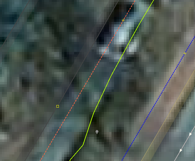
In JOSM 11639, a natural=tree object is represented by a grey pin. This has rather bad contrast with standard-brightness aerial imagery. (Old bing images are comparatively dark here.. but that's not the norm).
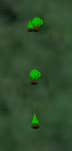
An icon like https://openclipart.org/detail/80/tree , when converted to small size, works better in my case. Maybe also for the general public.
https://openclipart.org/detail/263892/colorful-natural-tree seems acceptable too, though the increased color count reduces the contrast a little.


Attachments (3)
Change History (9)
by , 9 years ago
| Attachment: | treebing.png added |
|---|
comment:1 by , 9 years ago
| Component: | Core → Internal mappaint style |
|---|---|
| Keywords: | natural tree icon added |
comment:2 by , 9 years ago
| Description: | modified (diff) |
|---|
comment:3 by , 9 years ago
| Resolution: | → wontfix |
|---|---|
| Status: | new → closed |
This is only if you disable the data layer. If you keep it active, the icons have good color contrast:

by , 9 years ago
comment:4 by , 9 years ago
| Component: | Internal mappaint style → External mappaint style |
|---|
Thats not one of inactive core tree icons. It is much likely caused by an additional mappaint style. Attaching your statusreport would help to find the mappaint style.
comment:5 by , 9 years ago
URL:http://josm.openstreetmap.de/svn/trunk
Repository:UUID: 0c6e7542-c601-0410-84e7-c038aed88b3b
Last:Changed Date: 2017-02-26 23:10:22 +0100 (Sun, 26 Feb 2017)
Build-Date:2017-02-26 22:34:39
Revision:11639
Relative:URL: ^/trunk

Identification: JOSM/1.5 (11639 en) Linux openSUSE Leap 42.2
Memory Usage: 326 MB / 910 MB (57 MB allocated, but free)
Java version: 1.8.0_121-b13, Oracle Corporation, OpenJDK 64-Bit Server VM
Screen: :0.0 1920x1080
Maximum Screen Size: 1920x1080

Plugins:
+ FastDraw (33004)
+ HouseNumberTaggingTool (32699)
+ PicLayer (33148)
+ continuosDownload (53)
+ livegps (33138)
+ measurement (33088)
+ reverter (33088)
+ utilsplugin2 (33124)

Map paint styles:
+ <josm.pref>/roads.mss
+ https://josm.openstreetmap.de/josmfile?page=Styles/HiDPISupport&zip=1

audio.menuinvisible=true
autosave.interval=60
cache.bing.attribution.xml=1490599872
cache.capabilities1637351842=1490530293
cache.jcs.max_threads=2
cache.motd.html=1490530292
cache.motd.html.java=1.8.0_121
cache.motd.html.lang=En:
cache.motd.html.version=11639
color.gps.marker=#00FFFF
conflict.minimized=true
coordinates=DECIMAL_DEGREES
download.autorun=true
download.overpass.query=[way[railway]({{bbox}});
out meta;>;out meta;, node[highway=crossing]({{bbox}});
out meta;, node[highway=crossing][crossing_ref!~"."]({{bbox}});
out meta;, node[highway=crossing][crossing_ref=toucan]({{bbox}});
out meta;, node[highway=street_lamp]({{bbox}});
out
;
, node[highway=street_lamp]({{bbox}});
out
meta;
, way[building=shed]["building:levels"!~"."](user:<user.name>)({{bbox}});
out meta;>; out meta;, (
node[maxstay~"^P"]({{bbox}});
way[maxstay~"^P"]({{bbox}});
);
out meta;>; out meta;
, node[highway=street_lamp][color=yellow]({{bbox}});
out meta;, node[highway=street_lamp]["light:color"=yellow](user:<user.name>)({{bbox}});
out meta;, node[highway=street_lamp]["light:colour"=yellow](user:<user.name>)({{bbox}});
out meta;, node[highway=street_lamp]({{bbox}});
out meta;]
download.overpass.wizard=[]
download.places.history=[charagua airport, Altjeßnitz, Heinz-Hilpert-Straße, Göttingen, Albrechtstraße, Göttingen, Gervinusstraße, Göttingen, Emilienstraße, Göttingen, Wrocław, Poland, Bunzlauer, Göttingen, Brunnengasse, Göttingen, Brunnenbreite, Göttingen, Brockenweg, Göttingen, Am Mühlengraben, Göttingen, Am Markgraben, Göttingen, Albrecht-Haller-Straße, Göttingen, Suzuka Circuit]
downloadprimitive.full=false
downloadprimitive.lasttype=2
downloadprimitive.referrers=false
draw.splashscreen=false
expert=true
file-open.history=[]
font-size-summand=16
geoimage.docked=false
geoimage.geometry=x=755,y=414,width=406,height=226
gui.geometry=x=0,y=0,width=1920,height=1055
gui.maximized=true
imagery.cache.max_disk_size=256
imagery.entries=[{name=Bing aerial imagery, id=Bing, type=bing, url=http://www.bing.com/maps/, max-zoom=22, projections=, icon=data:image/png;base64,iVBORw0KGgoAAAANSUhEUgAAABgAAAAYCAMAAADXqc3KAAAAdVBMVEX/phX/04r/////6cX/zXz/7Mz/vFD/u0z/1I7/tT3/yXH/uEX/v1f/rCT/2pz/vlP/qRz/4a//yG3/xmn//Pj/9eb/+/T/897/t0H/wl7/sTL//vv/+O3/2Jn/7dD/+vH/9+n/3KT/tDr/9OL/8Nf/26D/ynSCVQVOAAAAkklEQVR4Xq3R1w7DIBQD0NiQne69d///E3tvBYVU6UsVPyEdCYycIOlOv5AB004Aaf6DCpLtF4yxp8tkFMGCkiEkKyGz9qCxrkxuhLIAeaijMvAwi/vMycJDuyi5/AVUaPwTPik5UdCDiWCjtd5Q70TK+KKD26M+6o+tdGxwIlmFPeyZn1yuraFKFOnt/sCz/81f+9UEaf1lPCAAAAAASUVORK5CYII=, noTileHeaders={"X-VE-Tile-Info":["no-tile"]}, metadataHeaders={"X-VE-TILEMETA-CaptureDatesRange":"Capture Date"}}, {name=OpenStreetMap Carto (Standard), id=standard, type=tms, url=https://{switch:a,b,c}.tile.openstreetmap.org/{zoom}/{x}/{y}.png, attribution-text=© OpenStreetMap contributors, CC-BY-SA, attribution-url=https://openstreetmap.org/, max-zoom=19, projections=, icon=data:image/png;base64,iVBORw0KGgoAAAANSUhEUgAAABgAAAAYCAYAAADgdz34AAAGb0lEQVR4Xq3MS2xcVx3H8e855z7m3vH1jMdjO43zshIrtpM0SZ3WFEcRVFFKoRWPBYtAHwgWCFUsQN100QeCsqAhCESrirRASdWWIkoUqgKFJm3UZ5o2oW2akrR5uXbi2ON4PPfOfZ17iERW2bCAz1/f3V8/cfDC02UEj4OxKHjdFMUfmUzOlAeXZFZuuVIKN8zi1dPh7Hcn5091G2EOB5b//NplA28/9tAT4bq111jD64ZKHR2VQWPEbULI0aHqZz7NZeLNmSeVMOJu4AfGgNEGLsR/95YuetcRzprcFJvaaVxrpm2mmqfp8FxKSYk8ck+0pt1nykFp0A/k9Tnt/lq3T2dHEOmi2DxSu+EdAAFwcPqp640xe42h26Qa2hqnXsFVHs04pNFuYgvbtOWCmD3aMj2VNaLi1+jwyxgpCKOQRCdMN6ZMd5Bmw1cPfG+5O/7LeX0ECyBppx9Zrn0c6BbNHJNr4qhFYWtsJCWpSFUm3ntxips2bxe+p1BKIJQECpRbkCQ2wu0XzbnIeemvhzYCVNR6JMDm5bdNF9qcwhiKbpvMg2KujZDmUgX1jgqT719gy+iX6QxsPM9F2YqclHbRRpUEXmCRZTGFlZGKxSMbR6+uA0gu863OzLc7cVUZN6jgKI8kicl0ykzjAiW5lGrVAWUwokApSa3UTY/XR2B3UlDgVy1sB8od7tgt2++4AcACOHL+uRW2bW8QQiCxcUoS6XssyBbnF6Y5+8kci8vjlJwqjnQwWpDlgtRYZDpHmxJzWUyk26gOYXxK0g+8G4bXX/snC0DZcmVh9EoQ5DpDSIVJYmIiGvkCurAQpkLU9kkTEEJeCjxbURSCZgTkfVjOApoM6Qtc3109Nj7uWO9M70EbPQT4YMhNjrWQEdHmTPs8SgfUisUgDLoAgcGyEjJtEaeaVlKQ5gVSGYwBhETaEmVJcemQaZ44aRpvyLIEnedGoNHNkNTTeI5DT2kRljeJziVhnKNlE1GaJFfnuRi3SXMDxmA7IUqCI20qdifkxfED+/dlanzb1cYL3BFhsTXPU4Ep0FGKUVALegCb1oLN7FlNpd5HIUNQLYxIsO0EKcByWljuAmXbp7fcIwgVb7xyaNeep3YfUnt272PLjaP1em/lZqmEk4cJQoMKfBxVIcwjlAp47okX6ap3XaoP221CIREyx7La2E6O7/h0eTXK+Bw+8uHrP7znvocXLe6flwCHXj06kab5hJAS6dhQFOgiJ2qXsKLVuHqAgdVD7HrwXibPTKJzFyMMAgECHGXTJTqxE4t3T5xMD7y29+mFRjgpLSUlYJ793T9ORWF0Lk1StCzQNqTTAle30flbzJ/bx6n3Xsa2Fb9/5Eccfu19wnlNFBniWJA3JecbDfa/8y5nJg7bW7ZeuyYKZwyF0QIAkC988Ogzfof6SppapHGZqgNTExPsfngfgaXpqyWk9QF6lwWk7YJlK1fQaTysqk8sE6LwIq4OEMql1DH3/O03PnBHUCk3JMCeA7/q6u1a0ltiNZ1eL719cPrcWR752d+Yn2lx/HSDY40qY2Pb2PapjYxv3YBX1syZ88weP3bp90Omw3PMOxNUe9FTn9gn5uemQqfk5BbAisHBlVo7g7PFx9TdgDMnZvjtzheI51qkWY5xYWxTLxXfJ5IVevIZ6gMDxCYnPjWDXZ0nSiOkEmYqO5l8cGT6FSD6+NhRJMCF1sWV88VkX6f3n/FHd+xl9uwsrTDEOIbPfWEj120eorw0JEzLhGWfop3ixxKrP0CTIQSAEVmhw5/f94uXAANg3b/r+1YrnV1T86ucPDzBrp3PcvHcHGmaUekL+OKtm9m0ailOUEe4FrXyWaKFblM4HmUvElNzF4jTxFiOhRRSJO34JHCOy6RU0i60uepfx07nO+593FycapAkCbX+Kl+/cxvXfXYIU3GjN/Yf2vPPg2/9JVxoNYNqQ+hcilznlKWDcpSwlCWiZrtx/O3Tf+AKClj88I9v/9aD99/aHBkaLlYNDTXuvPubH/3kN3e9vP3bn78HGAP6gSXA6K3fufnOXz+/888vHH3i9O4XH3j1roe+8dDo1pGvAeuAClfa/+aTQH35Yztuenz7l4aPLB9c81O/3H3L5VHFlUACZaAH6AQc/pv1o9cEiwbWbRlev+mrazeOblg3usnj/6nWV2fVyFp71fCa0sDgkOKyq5av4H/xb0Ky8po5hQEuAAAAAElFTkSuQmCC, valid-georeference=true}]
imagery.layers.default=[http://oatile{switch:1,2,3,4}.mqcdn.com/tiles/1.0.0/sat/{zoom}/{x}/{y}.png, http://www.bing.com/maps/, http://{switch:a,b,c}.tiles.mapbox.com/v4/openstreetmap.map-inh7ifmo/{zoom}/{x}/{y}.png?access_token=pk.eyJ1Ijoib3BlbnN0cmVldG1hcCIsImEiOiJncjlmd0t3In0.DmZsIeOW-3x-C5eX-wAqTw, https://tiles.wmflabs.org/bw-mapnik/{zoom}/{x}/{y}.png, https://{switch:a,b,c}.tile.openstreetmap.org/{zoom}/{x}/{y}.png]
imagery.tms.tmsloader.maxjobs=100
imagery.tms.tmsloader.maxjobsperhost=7
iso.dates=true
josm.version=11639
laf=com.sun.java.swing.plaf.gtk.GTKLookAndFeel
lastDirectory=${HOME}/osm/U30
livegps.minimized=true
mappaint.fontsize=10
mappaint.renderer-class-name=org.openstreetmap.josm.data.osm.visitor.paint.StyledMapRenderer
mappaint.style.entries=[{active=true, title=JOSM default (MapCSS), ptoken=standard, url=resource://styles/standard/elemstyles.mapcss}, {active=true, title=Potlatch 2, ptoken=standard, url=resource://styles/standard/potlatch2.mapcss}, {active=true, title=ROADS, url=<josm.pref>/roads.mss}, {active=true, title=HiDPI Support, url=https://josm.openstreetmap.de/josmfile?page=Styles/HiDPISupport&zip=1}]
mappaint.style.known-defaults=[resource://styles/standard/elemstyles.mapcss, resource://styles/standard/potlatch2.mapcss]
marker.audiofromstart=false
marker.traceaudio=false
measure.minimized=true
message.delete_from_relation=false
message.delete_from_relation.value=1
message.imagery.nagPanel.http://www.bing.com/maps/=false
message.imagery.nagPanel.http://{switch:a,b,c}.tiles.mapbox.com/v4/openstreetmap.map-inh7ifmo/{zoom}/{x}/{y}.png?access_token=pk.eyJ1Ijoib3BlbnN0cmVldG1hcCIsImEiOiJncjlmd0t3In0.DmZsIeOW-3x-C5eX-wAqTw=false
message.notifier.interval=60
message.overwriteAddKey=false
message.overwriteAddKey.value=1
message.upload_source_is_empty=false
message.upload_source_is_empty.value=3
mirror.<josm.pref>/cache/images.http://i.imgur.com/ib6TAEV.png=[1462623881602, <josm.pref>/cache/images/mirror_http___i.imgur.com_ib6TAEV.png]
mirror.<josm.pref>/cache/images.http://svn.openstreetmap.org/applications/editors/josm/plugins/cadastre-fr/images/cadastre_small.png=[1469906948146, <josm.pref>/cache/images/mirror_http___svn.openstreetmap.org_applications_editors_josm_plugins_cadastre-fr_images_cadastre_small.png]
mirror.<josm.pref>/cache/images.http://wiki.openstreetmap.org/w/images/2/25/Geoportal-josm.png=[1462623881508, <josm.pref>/cache/images/mirror_http___wiki.openstreetmap.org_w_images_2_25_Geoportal-josm.png]
mirror.<josm.pref>/cache/images.http://www.skobbler.com/images/skobbler_logo_josm.png=[1489066651159, <josm.pref>/cache/images/mirror_http___www.skobbler.com_images_skobbler_logo_josm.png]
mirror.<josm.pref>/cache/images.https://dl.dropboxusercontent.com/u/4031522/foto/gst_icon.png=[1463159297142, <josm.pref>/cache/images/mirror_https___dl.dropboxusercontent.com_u_4031522_foto_gst_icon.png]
mirror.https://josm.openstreetmap.de/josmfile?page_Styles/HiDPISupport&zip_1=[1490530293167, <josm.pref>/cache/mirror_https___josm.openstreetmap.de_josmfile_page_Styles_HiDPISupport_zip_1]
mirror.https://josm.openstreetmap.de/josmfile?page_Styles/Potlach2_access&zip_1=[1479551744771, <josm.pref>/cache/mirror_https___josm.openstreetmap.de_josmfile_page_Styles_Potlach2_access_zip_1]
mirror.https://josm.openstreetmap.de/maps=[1490610201142, <josm.pref>/cache/mirror_https___josm.openstreetmap.de_maps]
mirror.https://josm.openstreetmap.de/presets=[1489094093031, <josm.pref>/cache/mirror_https___josm.openstreetmap.de_presets]
mirror.https://josm.openstreetmap.de/rules=[1462564553438, <josm.pref>/cache/mirror_https___josm.openstreetmap.de_rules]
mirror.https://josm.openstreetmap.de/styles=[1480529891550, <josm.pref>/cache/mirror_https___josm.openstreetmap.de_styles]
notes/note_open.minimized=true
org.openstreetmap.josm.actions.OverpassDownloadAction$OverpassDownloadDialog.geometry=x=276,y=91,width=1149,height=888
org.openstreetmap.josm.actions.SessionSaveAsAction$SessionSaveAsDialog.geometry=x=785,y=304,width=350,height=450
org.openstreetmap.josm.gui.conflict.tags.CombinePrimitiveResolverDialog.geometry=x=3,y=0,width=1916,height=1051
org.openstreetmap.josm.gui.conflict.tags.PasteTagsConflictResolverDialog.geometry=x=660,y=340,width=600,height=400
org.openstreetmap.josm.gui.dialogs.ConflictResolutionDialog.geometry=x=310,y=166,width=1265,height=675
org.openstreetmap.josm.gui.dialogs.DeleteFromRelationConfirmationDialog.geometry=x=760,y=429,width=1035,height=200
org.openstreetmap.josm.gui.dialogs.InspectPrimitiveDialog.geometry=x=2185,y=238,width=750,height=550
org.openstreetmap.josm.gui.dialogs.properties.TagEditHelper$AddTagsDialog.geometry=x=1232,y=124,width=369,height=446
org.openstreetmap.josm.gui.dialogs.properties.TagEditHelper$EditTagDialog.geometry=x=247,y=827,width=1564,height=196
org.openstreetmap.josm.gui.dialogs.relation.GenericRelationEditor.geometry=x=695,y=107,width=835,height=926
org.openstreetmap.josm.gui.download.DownloadDialog.geometry=x=341,y=36,width=1285,height=1008
org.openstreetmap.josm.gui.download.DownloadObjectDialog.primitivesHistory=[62611, 5305531, 1423379313, 3209437,3209558,3348493]
org.openstreetmap.josm.gui.help.HelpBrowser.geometry=x=0,y=0,width=600,height=400
org.openstreetmap.josm.gui.history.HistoryBrowserDialogManager.geometry=x=4,y=0,width=1916,height=1051
org.openstreetmap.josm.gui.io.UploadDialog.geometry=x=538,y=123,width=1382,height=829
org.openstreetmap.josm.gui.oauth.OAuthAuthorizationWizard.geometry=x=735,y=259,width=600,height=540
org.openstreetmap.josm.gui.preferences.PreferenceDialog.geometry=x=159,y=129,width=1151,height=945
org.openstreetmap.josm.plugins.utilsplugin2.multitagger.MultiTagDialog.geometry=x=710,y=279,width=500,height=500
osm-download.bounds=51.5360322;9.9313214;51.5366145;9.9322334
osm-primitives.showid=true
osm-server.upload-strategy=singlerequest
osm.notes.daysClosed=90
piclayer.autoloadcal=yes
piclayer.lastdir=${HOME}/osm/bau
plugin.continuos_download.active_default=false
plugin.continuos_download.extra_download=0
plugin.continuos_download.max_area=0.02
plugin.continuos_download.quiet_download=true
pluginmanager.lastupdate=1488626618082
pluginmanager.version=11639
plugins=[FastDraw, HouseNumberTaggingTool, PicLayer, continuosDownload, livegps, measurement, reverter, utilsplugin2]
progressdialog.size=593
projection.sub=[]
projection.sub.core:mercator=[]
properties.recent-tags=[man_made, tower, man_made, flagpole, source, survey 2017-03-26, operator, Windmann Schaumstoffe, operator, Fressnapf, ref, G-5653, ref, G-5652, ref, G-5651, ref, G-5642, ref, G-5643, ref, G-5644, ref, G-5646, ref, G-5648, ref, G-5650, ref, G-5649, ref, G-5647, ref, G-5645, lamp_model:de, Pilzleuchte, light:method, high_pressure_sodium, light:count, 5, name, MH/CYL, waterway, stream, name, MH, name, unlit on weekends, landuse, industrial, highway, residential, name, LED, highway, primary, name, CFL, highway, unclassified]
propertiesdialog.geometry=x=762,y=441,width=396,height=176
proxy.policy=no-proxy
reverter.ChangesetIdQuery.changesetsHistory=[46310062, 41679830]
search.history=[R maxstay=P4H, R maxstay=P3H, R maxstay=P1H, R maxstay=P2H, R "light:colour"="w", R name="Hainberg-Gymnasium", R traffic_sign="DE:254;DE:239", R traffic_sign="DE:254,DE:239", R source="https://www.pwdesign.de/", R "light:shape"="cylindrical", R support=catenary, R "light:shape"="", R "light:tilt"="", R "light:lit"="", R "light:colour"=""]
selectionlist.geometry=x=733,y=442,width=459,height=176
selectionlist.minimized=true
shortcut.entry.tools:followline=[Tool: Follow, 70, 5003, 70, -1, false, true]
sourcetag.value=survey 2017-03-26
taggingpreset.entries=[{title=Internal Preset, url=resource://data/defaultpresets.xml}]
toggleDialogs.width=421
toolbar=[open, save, downloadprimitive, overpassdownload/download, continuosdownload/activate, download, upload, |, undo, redo, |, dialogs/search(searchExpression=), preference, |, splitway, combineway, wayflip, |, imagery-offset, |, tagginggroup_Highways/Streets, tagginggroup_Highways/Ways, tagginggroup_Highways/Waypoints, tagginggroup_Highways/Barriers, |, tagginggroup_Transport/Car, tagginggroup_Transport/Public Transport, |, tagginggroup_Facilities/Tourism, tagginggroup_Facilities/Food+Drinks, |, tagginggroup_Man Made/Historic Places, |, tagginggroup_Man Made/Man Made]
upload.comment.history=[add lamp, set count, set method, natrium lamps are commonly characterized as orange, not yellow, Laternen einfügen, Laternen, Werbetafeln einfügen, Laden steht vakant, improve way intersections (60° crossing angle), Neubauten am Friedhof, adhere to ISO8601 format, type=multipolygon auf Way ist falsch, Jheringstr. 72 ist fertig gebaut, Werbetafeln einfügen, Destruktion des Polygons in Changeset 45175455 by t2425b rückgängig machen, Bäume hinzufügen]
upload.comment.last-used=1490572131
upload.source.history=[, survey 2016-09-10, own survey in 2016-09, bing(outlines)/survey(data), knowledge, survey, Bing]
utilsplugin2.customurl=https://www.openstreetmap.org/{#type}/{#id}/history
utilsplugin2.urlHistory=[Wikipedia, https://en.wikipedia.org/w/index.php?search={name}&fulltext=Search, Wikipedia RU, http://osm.mapki.com/history/{#type}.php?id={#id}, Who Dit It?, http://simon04.dev.openstreetmap.org/whodidit/?zoom=12&lat={#lat}&lon={#lon}&layers=BTT, Keep Right validator, http://keepright.ipax.at/report_map.php?zoom=14&lat={#lat}&lon={#lon}&layers=B0T, Element history [demo, =Ctrl-Shift-H], https://www.openstreetmap.org/{#type}/{#id}/history, Browse element [demo, =Ctrl-Shift-I], https://www.openstreetmap.org/{#type}/{#id}]
validator.minimized=true
validator.org.openstreetmap.josm.data.validation.tests.MapCSSTagChecker.entries=[{active=true, title=Addresses, url=resource://data/validator/addresses.mapcss}, {active=true, title=Tag combinations, url=resource://data/validator/combinations.mapcss}, {active=true, title=Deprecated features, url=resource://data/validator/deprecated.mapcss}, {active=true, title=Geometry, url=resource://data/validator/geometry.mapcss}, {active=true, title=Highways, url=resource://data/validator/highway.mapcss}, {active=true, title=Multiple values, url=resource://data/validator/multiple.mapcss}, {active=true, title=Numeric values, url=resource://data/validator/numeric.mapcss}, {active=true, title=Religion, url=resource://data/validator/religion.mapcss}, {active=true, title=Relations, url=resource://data/validator/relation.mapcss}, {active=true, title=Unnecessary tags, url=resource://data/validator/unnecessary.mapcss}, {active=true, title=Wikipedia, url=resource://data/validator/wikipedia.mapcss}, {active=true, title=Territories, url=resource://data/validator/territories.mapcss}]
validator.skip=[]
validator.skipBeforeUpload=[]
validator.visible=true
comment:6 by , 9 years ago
Try to disable all the additional all additional mappaint styles and remove <josm.pref>/roads.mss Thats probably not a mapcss mappaint style josm can handle.
josm tree icon on dark bing example