Opened 11 years ago
Last modified 4 years ago
#11189 new defect
Geotagged images taken out on surveys taken close together do not show seperately in JOSM
| Reported by: | Owned by: | team | |
|---|---|---|---|
| Priority: | normal | Milestone: | |
| Component: | Core image mapping | Version: | |
| Keywords: | template_report, images, icons | Cc: |
Description (last modified by )
What steps will reproduce the problem?
- Take some images with OSMTracker (for example) within a few feet of each other
- Load GPX with images into JOSM
- Click on image icons
What is the expected result?
All images should show as a clickable icon in JOSM
What happens instead?
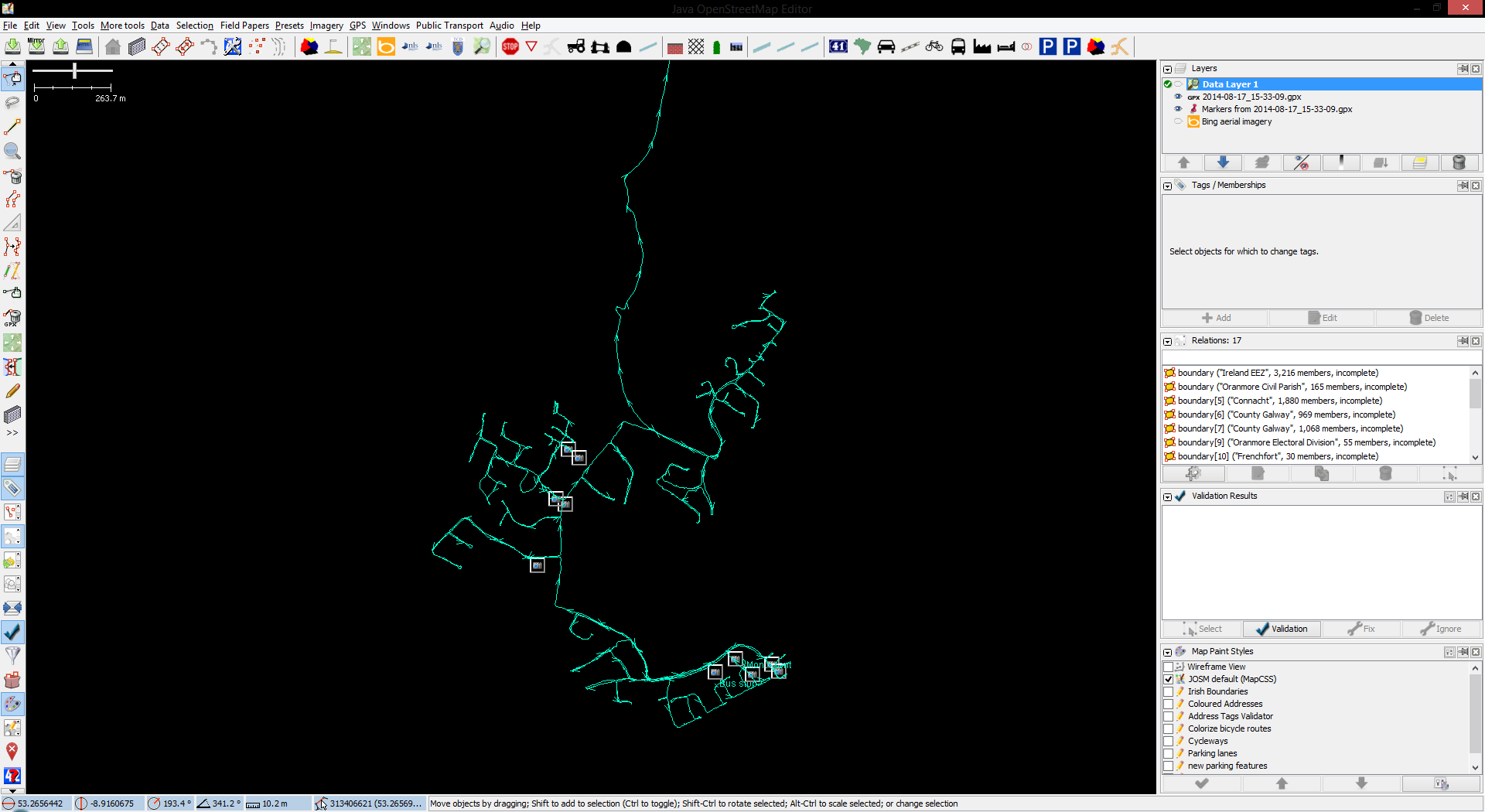
As some images are taken close together on the ground, not all show up in the JOSM window.
Please provide any additional information below. Attach a screenshot if possible.
I am attaching a screenshot of a GPX trace where I took 22 images, but only 10 icons show up in JOSM.
I have uploaded this GPX trace and associated images to a dropbox folder so anyone can load it up to get a better understanding of the issue.
The dropbox folder is located here - https://www.dropbox.com/sh/wuu0wtzrzpb5bnq/AABwqslEEcW-Rjf7nq0On4I_a?dl=0
Revision: 7995
Repository Root: http://josm.openstreetmap.de/svn
Relative URL: ^/trunk
Last Changed Author: Don-vip
Last Changed Date: 2015-01-31 15:17:59 +0100 (Sat, 31 Jan 2015)
Build-Date: 2015-02-01 02:33:54
URL: http://josm.openstreetmap.de/svn/trunk
Repository UUID: 0c6e7542-c601-0410-84e7-c038aed88b3b
Last Changed Rev: 7995

Identification: JOSM/1.5 (7995 en) Windows 8.1 64-Bit
Memory Usage: 534 MB / 989 MB (136 MB allocated, but free)
Java version: 1.8.0_25, Oracle Corporation, Java HotSpot(TM) Client VM
Dataset consistency test: No problems found

Plugins:
- AddrInterpolation (30892)
- BuildingGeneralization (UNKNOWN)
- DirectDownload (30892)
- DirectUpload (30892)
- FastDraw (30892)
- FixAddresses (30892)
- HouseNumberTaggingTool (30892)
- OpeningHoursEditor (30962)
- PicLayer (30962)
- alignways (30892)
- buildings_tools (30955)
- contourmerge (1012)
- dataimport (30892)
- download_along (30892)
- editgpx (30892)
- ext_tools (30892)
- fieldpapers (b49dadd)
- geochat (30892)
- gpxfilter (30892)
- imagery_offset_db (30892)
- imageryadjust (30892)
- measurement (30892)
- mirrored_download (30962)
- namemanager (30892)
- notes (v0.9.5)
- osmarender (30892)
- print (30892)
- public_transport (30892)
- reltoolbox (30892)
- reverter (30990)
- tageditor (30892)
- terracer (30892)
- todo (29154)
- turnlanes (30892)
- turnrestrictions (30892)
- utilsplugin2 (30892)
- walkingpapers (30892)
- wikipedia (30892)

Last errors/warnings:
- W: TMS - Failed downloading https://c.tile.openstreetmap.org/15/15572/10633.png: Connection timed out: connect
- W: TMS - Failed downloading https://a.tile.openstreetmap.org/15/15570/10632.png: Connection timed out: connect
- W: TMS - Failed downloading https://a.tile.openstreetmap.org/15/15571/10633.png: Connection timed out: connect
- W: TMS - Failed downloading http://ecn.t1.tiles.virtualearth.net/tiles/a031310231012013311.jpeg?g=3299: connect timed out
- W: TMS - Failed downloading http://ecn.t0.tiles.virtualearth.net/tiles/a031310231012013133.jpeg?g=3299: connect timed out
Attachments (2)
Change History (10)
by , 11 years ago
| Attachment: | Clipboard01.png added |
|---|
comment:1 by , 11 years ago
| Owner: | changed from to |
|---|---|
| Status: | new → needinfo |
Please attach the GPX file as well.
comment:2 by , 11 years ago
I've attached the GPX file as requested, wasnt sure if you wanted the images that go with it. Note, this is already linked above to a dropbox folder
I can't upload the images as it would take hours on my connection. Please pull from the linked dropbox folder
comment:3 by , 11 years ago
| Component: | Core → Core image mapping |
|---|---|
| Description: | modified (diff) |
| Owner: | changed from to |
| Status: | needinfo → new |
follow-up: 5 comment:4 by , 11 years ago
The photos are displayed according to their coordinates. You need to zoom in to see them at different locations. You have the same issue with nodes that are close together. But we could display a number to indicate that there is more than one photo if they overlap e.g. more than 90%.
comment:5 by , 11 years ago
Replying to holgermappt:
The photos are displayed according to their coordinates. You need to zoom in to see them at different locations. You have the same issue with nodes that are close together. But we could display a number to indicate that there is more than one photo if they overlap e.g. more than 90%.
That would probably work. Something along the lines of how clustering works in leaflet maybe?
comment:6 by , 9 years ago
Right, some kind of clustering would be necessary to decide where to place the object number. Something like this: https://developers.google.com/maps/documentation/android-api/utility/marker-clustering (see the image example at the end of that page).
It's also possible that multiple images have the exact same coordinates. Then it would be good to add an artificial offset for the display such that they don't overlap on high zoom levels. Or a spiderfier like here: https://github.com/jawj/OverlappingMarkerSpiderfier, maybe in combination with clustering.
I'm not aware that JOSM supports something like that and to implement it would be quite some effort.


screenshot of JOSM showing only 10 image icons for 22 images taken