

| Version 23 (modified by , 11 years ago) ( diff ) |
|---|
This page is missing some new options and the list of commands is probably better situated on a separate page.
Languages:
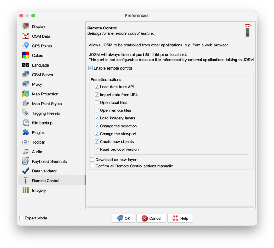
Preferences > Remote Control
 Settings for the remote control feature.
Remote Control allows JOSM to be controlled from other applications, e.g. from a web browser, by opening a listening TCP port (8111) on localhost where it accepts commands.
Since JOSM version 6941 it is also listening for HTTPS on port 8112.
Note: Due to security reasons this feature is disabled in the default settings and has to be enabled manually.
If you access the a website via HTTPS and use the Remote Control it will also use HTTPS to control your JOSM. If it does not work, note that your browser, security addons/plugins and firewalls may block this access (you may be able to whitelist/allow it inside these tools) – check your logs. In addition you may need to tell your browser to accept the self-signed JOSM HTTPS certificate. More details on some of these issues: How do I enable the "remote control" in JOSM? (on the OSM help site).
The following control options are available:

- Enable remote control allows to switch the remote control feature on or off.
- Load data from API
- Import data from URL
- Load imagery layers
- Change the selection
- Change the viewport
- Create new objects
- Read protocol version
- Confirm all Remote Control actions manually
List of Commands
A complete list of commands and mandatory/optional parameters is shown at http://127.0.0.1:8111/ (when JOSM is running).
load_and_zoom
Instructs JOSM to download a bounding box from the API, zoom to the downloaded area and optionally select one or more objects.
GET /load_and_zoom?left=...&right=...&top=...&bottom=...&select=object[,object...]
where
| Parameter | Required/Optional | Meaning |
|---|---|---|
left | R | minimum longitude |
right | R | maximum longitude |
bottom | R | minimum latitude |
top | R | maximum latitude |
select | O | comma-separated list of objects that should be selected. Object specifiers are combinations of the words "way", "node", or "relation", and the numerical object id. Example: select=way38473,node12399,node54646
|
addtags | O | Optional parameter to add tags. The key and value is separated by "=" and multiple tags can be separated by a Pipe "|". See details. |
new_layer | O | If true, downloads to a new layer |
Example
Start JOSM (don't forget to enable the RemoteControl feature), then click on:
JOSM should now load an area in the German Schwarzwald and have the specified node selected.
zoom
Instructs JOSM to zoom to the specified area and optionally select one or more objects.
GET /zoom?left=...&right=...&top=...&bottom=...&select=object[,object...]
Accepts the same parameters as the load_and_zoom command and uses the same code for zoom and selection. The only difference is that no data will be loaded from the API.
Hint: This command can also be used to select objects only. Just enter a small arbitrary area to the left..bottom entries and add the object list to the select= option.
import
Instructs JOSM to download the specified OSM file and add it to the current data set.
GET /import?url=...
load_data
Instruct JOSM to load OSM data, directly encoded in the URL, instead of coming from an external file. This is only suited for smaller data (some browsers limit the maximum URL length), but it is faster (since no download is required), and in many cases where dynamically generated data is needed, it's easier to generate.
GET /load_data?new_layer=(true/false)&layer_name=...&mime_type=...&data=...
where
| Parameter | Required/Optional | Meaning |
|---|---|---|
new_layer | O | Chose to load the data in a new layer |
layer_name | O | Only valid when the data is loaded in a new layer; Gives JOSM a hint on how to name the layer |
mime_type | O | Mime type of the data, by default this is "application/x-osm+xml", which is currently the only supported mime type, but in the future other mime types could be supported |
data | R | The XML data to load, this should be URL encoded in a way that also encodes the special characters &, = and ? to resp. %26, %3D and %3F. The JS encodeUriComponent() method provides this functionality out of the box. |
imagery
Instructs JOSM to add an imagery (WMS/TMS) layer.
GET /imagery?title=...&type=...&url=...
where
| Parameter | Required/Optional | Meaning |
|---|---|---|
title | O | The display name of the layer |
type | O | Type of the layer. Possible values are wms, tms and bing (since RemoteControl Version 1.3) |
min_zoom | O | The minimum zoom level (since RemoteControl Version 1.4) |
max_zoom | O | The maximum zoom level. For higher scales, the images of the maximum level is enlarged (since RemoteControl Version 1.4) |
url | R | The Request URL, including patterns. Must be the last parameter, everything after "&url=" is interpreted as URL, even if it contains "&" characters. |
Examples
- TMS layer "osm"
http://tile.openstreetmap.org/{zoom}/{x}/{y}.png
- WMS layer "landsat"
http://irs.gis-lab.info/?layers=landsat&SRS={proj}&WIDTH={width}&HEIGHT={height}&BBOX={bbox}
load_object
Instructs JOSM to download objects with a given id.
GET /load_object?new_layer=true|false&objects=...
where
| Parameter | Required/Optional | Meaning |
|---|---|---|
objects | R | Comma separated list of object ids, e.g. "n1234,n1235,w84,r958493"
|
new_layer | O | If true, downloads to a new layer |
addtags | O | Optional parameter to add tags. The key and value is separated by "=" and multiple tags can be separated by a Pipe "|". See details. |
referrers | O | If true, downloads referrers of the object as well. I.e. parent relations, and for nodes, additionally, parent ways. (since r6782) |
Example
http://localhost:8111/load_object?new_layer=true&objects=w106159509
add_node
Instructs JOSM to create a new node at the given coordinates.
Note: This action requires the permission Create new objects which is disabled by default.
GET /add_node?lon=...&lat=...
where
| Parameter | Required/Optional | Meaning |
|---|---|---|
lon | R | The longitude of the node |
lat | R | The latitude of the node |
addtags since v1.5 | O | Optional parameter to add tags. The key and value is separated by "=" and multiple tags can be separated by a Pipe "|". See details. |
Example
http://localhost:8111/add_node?lon=13.3&lat=53.2
add_way
Instructs JOSM to create a new way with new way nodes at given coordinates.
Note: This action requires the permission Create new objects which is disabled by default.
GET /add_way?way=lat1,lon1;lat2,lon2;...
where
| Parameter | Required/Optional | Meaning |
|---|---|---|
way | R | Pairs of latitude, longitude coordinates separated by semicolon. |
addtags since v1.5 | O | Optional parameter to add tags. The key and value is separated by "=" and multiple tags can be separated by a Pipe "|". See details. |
Example
http://localhost:8111/add_way?way=53.2,13.3;53.3,13.3;53.3,13.2
version
This command returns the current protocol version of the installed RemoteControl interface. Developers can use it to query for a running instance of JOSM and also determine whether the requested functionality is available in the client.
GET /version[?jsonp=callback]
The command returns a json object containing an application identifier that is always "JOSM RemoteControl", a major number and a minor number. Compatible protocol changes result in an increase of the minor number. Incompatible changes increase the major number. So a client application knowing of protocol version 1.0 can still talk to JOSM having 1.1. But it's not guaranteed to be working with 2.0. So the client should verify the major number.
A typical output looks like this:
{
   "protocolversion": {
      "major": 1,
      "minor": 0
   },
   "application": "JOSM RemoteControl"
}
For older browsers not implementing Cross-Origin Resource Sharing (CORS) the command provides the possibility for jsonp callback. Load the URL in a script tag and supply the name of a callback that will receive the JSON data.
Following is some sample code that checks for CORS capabilities and uses JSONP as a fallback solution.
// in addition to the CC-BY-SA of the wiki feel free to use the following source for any purpose without restrictions (PD)
// credits and additions appreciated: http://wiki.openstreetmap.org/wiki/User:Stephankn

function checkJOSM(version){
   alert(version.application + " uses protocol version " + version.protocolversion.major + "." + version.protocolversion.minor);
   // do something useful, maybe showing edit button
}

var url = "http://127.0.0.1:8111/version";
var useFallback = false;
// currently FF3.5, Safari 4 and IE8 implement CORS
if (XMLHttpRequest) {
   var request = new XMLHttpRequest();
   if ("withCredentials" in request) {
      request.open('GET', url, true);
      request.onreadystatechange = function(){
         if (request.readyState != 4) {
            return;
         }
         if (request.status == 200) {
            checkJOSM(eval('(' + request.responseText + ')'));
         }
      };
      request.send();
   }
   else if (XDomainRequest) {
      var xdr = new XDomainRequest();
      xdr.open("get", url);
      xdr.onload = function(){
         checkJOSM(eval('(' + xdr.responseText + ')'));
      };
      xdr.send();
   } else {
      useFallback = true;
   }
}
else {
   // no XMLHttpRequest available
   useFallback = true;
}

if (useFallback) {
   // Use legacy jsonp call
   var s = document.createElement('script');
   s.src = url + '?jsonp=checkJOSM';
   s.type = 'text/javascript';

   if (document.getElementsByTagName('head').length > 0) {
      document.getElementsByTagName('head')[0].appendChild(s);
   }

}
Adding, changing or deleting tags
Try this example: http://localhost:8111/load_and_zoom?addtags=wikipedia:de=Wei%C3%9Fe_Gasse|maxspeed=5&select=way23071688,way23076176,way23076177,&left=13.739727546842&right=13.740890970188&top=51.049987191025&bottom=51.048466954325. (Works also with the zoom-command)
The user must review the tags and the selection before the tags are applied to the selected objects. If the tag exists on some objects, it will be can be replaced.
Since protocol version 1.5
add_nodeandadd_waycommands supportaddtagsparameter- It is possible to use
=character in value and all leading/trailing spaces are trimmed.
http://localhost:8111/add_node?lon=13.3&lat=53.2&addtags=natural=tree|name=%20%20%20==Great%20Oak== (creates node with natural=tree an name="==Great Oak==")
- If empty value is found, tag is to be deleted from objects (checkbox-confirmation is needed)
Other commands
Remotecontrol allows other plugins to add additional commands. The other registers a RequestHandler class and specifies a command to be handled by this class. The command syntax has to be defined by the other plugin.
Reverter plugin since version 27091 makes use of this feature.
See also
Old JOSM Remote-Plugin page at OSM wiki
Back to Preferences
Back to Main Help
Attachments (3)
- remote_control.png (72.0 KB ) - added by 8 years ago.
-
PreferencesRemoteControl.png
(181.3 KB
) - added by 5 years ago.
new screenshot
- PreferencesRemoteControl.2.png (177.2 KB ) - added by 9 months ago.
Download all attachments as: .zip