

| Version 15 (modified by , 13 years ago) ( diff ) |
|---|
Preset for Seamarks used in Openseamap.org
This preset was created by padde. Most of the icons were copied from the OpenSeaMap/CEVNI Notice Mark page http://wiki.openstreetmap.org/wiki/OpenSeaMap/CEVNI_Notice_Marks.
The preset looks like this:
 screenshot of preset seamarks used in josm")
<presets author="padde" version="0.32_2021-11-25" shortdescription="Seamarks" description="Preset to easily add seamarks"> <separator/> <group name="seamarks" de.name="Seezeichen" icon="Notice_A6.png"> <group name="Prohibitory Signs" de.name="Verbotszeichen" icon="Notice_A6.png"> <item name="no entry" de.name="Einfahrt verboten" fr.name="no entry" icon="Notice_A1.png" type="node"> <link href="http://wiki.openstreetmap.org/wiki/OpenSeaMap/CEVNI_Notice_Marks" de.href="http://wiki.openstreetmap.org/wiki/OpenSeaMap/CEVNI_Notice_Marks"/> <link href="http://wiki.openstreetmap.org/wiki/OpenSeaMap/Notice_Marks"/> <label text="Seamark no entry" de.text="Seezeichen: Einfahrt verboten"/> <space/> <key key="seamark:type" value="notice"/> <key key="seamark:notice:category" value="no_entry"/> <key key="seamark:notice:function" value="prohibition"/> <combo key="seamark:notice:impact" text="Impact" de.text="gültig für" values=",upstream, downstream, left_bank,right_bank" default="" delete_if_empty="true" /> <combo key="seamark:notice:orientation" text="orientation 0-360" de.text="Ausrichtung 0-360" values=",0,45,90,135,180,225,270,315" default="0" delete_if_empty="true"/> <text key="seamark:notice:distance_down" text="downstream disctance of an impact of an area" de.text="Entfernung Flussabwärts" default="" delete_if_empty="true"/> <text key="seamark:notice:distance_up" text="Upstream distance of the impact of an area" de.text="Entfernung Flussaufwärts" default="" delete_if_empty="true"/> <text key="seamark:notice:distance_start" text="minimum distance from notice rectangular to bank" de.text="min. Entfernung orthogonal zum Ufer" default="" delete_if_empty="true"/> <text key="seamark:notice:distance_end" text="maximum distance from notice rectangular to bank" de.text="max. Entfernung orthogonal zum Ufer" default="" delete_if_empty="true"/> <combo key="seamark:notice:addition" text="Impact" de.text="gültig für" values=",top_board,bottom_board,right_triangle,left_triangle,bottom_triangle" default="" delete_if_empty="true" /> <text key="name" text="Name national" de.text="Name in Landessprache" fr.text="Nom national" default="" delete_if_empty="true"/> <text key="note" text="Note" de.text="Bemerkung" fr.text="Remarque" default="FIXME" delete_if_empty="true"/> </item> <item name="closed area" de.name="geschlossenes Gebiet" icon="Notice_A1a.png" type="node"> <link href="http://wiki.openstreetmap.org/wiki/OpenSeaMap/CEVNI_Notice_Marks" de.href="http://wiki.openstreetmap.org/wiki/OpenSeaMap/CEVNI_Notice_Marks"/> <label text="Seamark: closed area" de.text="Seezeichen: geschlossenes Gebiet"/> <space/> <key key="seamark:type" value="notice"/> <key key="seamark:notice:category" value="closed_area"/> <key key="seamark:notice:function" value="prohibition"/> <combo key="seamark:notice:impact" text="Impact" de.text="gültig für" values=",upstream, downstream, left_bank,right_bank" default="" delete_if_empty="true" /> <combo key="seamark:notice:orientation" text="orientation 0-360" de.text="Ausrichtung 0-360" values=",0,45,90,135,180,225,270,315" default="0" delete_if_empty="true"/> <text key="seamark:notice:distance_down" text="downstream disctance of an impact of an area" de.text="Entfernung Flussabwärts" default="" delete_if_empty="true"/> <text key="seamark:notice:distance_up" text="Upstream distance of the impact of an area" de.text="Entfernung Flussaufwärts" default="" delete_if_empty="true"/> <text key="seamark:notice:distance_start" text="minimum distance from notice rectangular to bank" de.text="min. Entfernung orthogonal zum Ufer" default="" delete_if_empty="true"/> <text key="seamark:notice:distance_end" text="maximum distance from notice rectangular to bank" de.text="max. Entfernung orthogonal zum Ufer" default="" delete_if_empty="true"/> <combo key="seamark:notice:addition" text="Impact" de.text="gültig für" values=",top_board,bottom_board,right_triangle,left_triangle,bottom_triangle" default="" delete_if_empty="true" /> <text key="name" text="Name national" de.text="Name in Landessprache" fr.text="Nom national" default="" delete_if_empty="true"/> <text key="note" text="Note" de.text="Bemerkung" fr.text="Remarque" default="FIXME" delete_if_empty="true"/> </item> <item name="no overtaking" de.name="Überholverbot" icon="Notice_A2.png" type="node"> <link href="http://wiki.openstreetmap.org/wiki/OpenSeaMap/CEVNI_Notice_Marks" de.href="http://wiki.openstreetmap.org/wiki/OpenSeaMap/CEVNI_Notice_Marks"/> <label text="Seamark: no overtaking" de.text="Seezeichen: Überholverbot"/> <space/> <key key="seamark:type" value="notice"/> <key key="seamark:notice:category" value="no_overtaking"/> <key key="seamark:notice:function" value="prohibition"/> <combo key="seamark:notice:impact" text="Impact" de.text="gültig für" values=",upstream, downstream, left_bank,right_bank" default="" delete_if_empty="true" /> <combo key="seamark:notice:orientation" text="orientation 0-360" de.text="Ausrichtung 0-360" values=",0,45,90,135,180,225,270,315" default="0" delete_if_empty="true"/> <text key="seamark:notice:distance_down" text="downstream disctance of an impact of an area" de.text="Entfernung Flussabwärts" default="" delete_if_empty="true"/> <text key="seamark:notice:distance_up" text="Upstream distance of the impact of an area" de.text="Entfernung Flussaufwärts" default="" delete_if_empty="true"/> <text key="seamark:notice:distance_start" text="minimum distance from notice rectangular to bank" de.text="min. Entfernung orthogonal zum Ufer" default="" delete_if_empty="true"/> <text key="seamark:notice:distance_end" text="maximum distance from notice rectangular to bank" de.text="max. Entfernung orthogonal zum Ufer" default="" delete_if_empty="true"/> <combo key="seamark:notice:addition" text="Impact" de.text="gültig für" values=",top_board,bottom_board,right_triangle,left_triangle,bottom_triangle" default="" delete_if_empty="true" /> <text key="name" text="Name national" de.text="Name in Landessprache" fr.text="Nom national" default="" delete_if_empty="true"/> <text key="note" text="Note" de.text="Bemerkung" fr.text="Remarque" default="FIXME" delete_if_empty="true"/> </item> <item name="no convoy overtaking" de.name="Überholverbot für Schleppverbände" icon="Notice_A3.png" type="node"> <link href="http://wiki.openstreetmap.org/wiki/OpenSeaMap/CEVNI_Notice_Marks" de.href="http://wiki.openstreetmap.org/wiki/OpenSeaMap/CEVNI_Notice_Marks"/> <label text="Seamark: no convoy overtaking" de.text="Seezeichen: Überholverbot für Schleppverbände"/> <space/> <key key="seamark:type" value="notice"/> <key key="seamark:notice:category" value="no_convoy_overtaking"/> <key key="seamark:notice:function" value="prohibition"/> <combo key="seamark:notice:impact" text="Impact" de.text="gültig für" values=",upstream, downstream, left_bank,right_bank" default="" delete_if_empty="true" /> <combo key="seamark:notice:orientation" text="orientation 0-360" de.text="Ausrichtung 0-360" values=",0,45,90,135,180,225,270,315" default="0" delete_if_empty="true"/> <text key="seamark:notice:distance_down" text="downstream disctance of an impact of an area" de.text="Entfernung Flussabwärts" default="" delete_if_empty="true"/> <text key="seamark:notice:distance_up" text="Upstream distance of the impact of an area" de.text="Entfernung Flussaufwärts" default="" delete_if_empty="true"/> <text key="seamark:notice:distance_start" text="minimum distance from notice rectangular to bank" de.text="min. Entfernung orthogonal zum Ufer" default="" delete_if_empty="true"/> <text key="seamark:notice:distance_end" text="maximum distance from notice rectangular to bank" de.text="max. Entfernung orthogonal zum Ufer" default="" delete_if_empty="true"/> <combo key="seamark:notice:addition" text="Impact" de.text="gültig für" values=",top_board,bottom_board,right_triangle,left_triangle,bottom_triangle" default="" delete_if_empty="true" /> <text key="name" text="Name national" de.text="Name in Landessprache" fr.text="Nom national" default="" delete_if_empty="true"/> <text key="note" text="Note" de.text="Bemerkung" fr.text="Remarque" default="FIXME" delete_if_empty="true"/> </item> <item name="no passing" de.name="Begegnen Verboten" icon="Notice_A4.png" type="node"> <link href="http://wiki.openstreetmap.org/wiki/OpenSeaMap/CEVNI_Notice_Marks" de.href="http://wiki.openstreetmap.org/wiki/OpenSeaMap/CEVNI_Notice_Marks"/> <label text="Seamark: no passing" de.text="Seezeichen: Begegnen verboten"/> <space/> <key key="seamark:type" value="notice"/> <key key="seamark:notice:category" value="no_passing"/> <key key="seamark:notice:function" value="prohibition"/> <combo key="seamark:notice:impact" text="Impact" de.text="gültig für" values=",upstream, downstream, left_bank,right_bank" default="" delete_if_empty="true" /> <combo key="seamark:notice:orientation" text="orientation 0-360" de.text="Ausrichtung 0-360" values=",0,45,90,135,180,225,270,315" default="0" delete_if_empty="true"/> <text key="seamark:notice:distance_down" text="downstream disctance of an impact of an area" de.text="Entfernung Flussabwärts" default="" delete_if_empty="true"/> <text key="seamark:notice:distance_up" text="Upstream distance of the impact of an area" de.text="Entfernung Flussaufwärts" default="" delete_if_empty="true"/> <text key="seamark:notice:distance_start" text="minimum distance from notice rectangular to bank" de.text="min. Entfernung orthogonal zum Ufer" default="" delete_if_empty="true"/> <text key="seamark:notice:distance_end" text="maximum distance from notice rectangular to bank" de.text="max. Entfernung orthogonal zum Ufer" default="" delete_if_empty="true"/> <combo key="seamark:notice:addition" text="Impact" de.text="gültig für" values=",top_board,bottom_board,right_triangle,left_triangle,bottom_triangle" default="" delete_if_empty="true" /> <text key="name" text="Name national" de.text="Name in Landessprache" fr.text="Nom national" default="" delete_if_empty="true"/> <text key="note" text="Note" de.text="Bemerkung" fr.text="Remarque" default="FIXME" delete_if_empty="true"/> </item> <item name="no convoy passing" de.name="Begegnen für Schleppverbände Verboten" icon="Notice_A4_1.png" type="node"> <link href="http://wiki.openstreetmap.org/wiki/OpenSeaMap/CEVNI_Notice_Marks" de.href="http://wiki.openstreetmap.org/wiki/OpenSeaMap/CEVNI_Notice_Marks"/> <label text="Seamark: no convoy passing" de.text="Seezeichen: Begegnen für Schleppverbände verboten"/> <space/> <key key="seamark:type" value="notice"/> <key key="seamark:notice:category" value="no_convoy_passing"/> <key key="seamark:notice:function" value="prohibition"/> <combo key="seamark:notice:impact" text="Impact" de.text="gültig für" values=",upstream, downstream, left_bank,right_bank" default="" delete_if_empty="true" /> <combo key="seamark:notice:orientation" text="orientation 0-360" de.text="Ausrichtung 0-360" values=",0,45,90,135,180,225,270,315" default="0" delete_if_empty="true"/> <text key="seamark:notice:distance_down" text="downstream disctance of an impact of an area" de.text="Entfernung Flussabwärts" default="" delete_if_empty="true"/> <text key="seamark:notice:distance_up" text="Upstream distance of the impact of an area" de.text="Entfernung Flussaufwärts" default="" delete_if_empty="true"/> <text key="seamark:notice:distance_start" text="minimum distance from notice rectangular to bank" de.text="min. Entfernung orthogonal zum Ufer" default="" delete_if_empty="true"/> <text key="seamark:notice:distance_end" text="maximum distance from notice rectangular to bank" de.text="max. Entfernung orthogonal zum Ufer" default="" delete_if_empty="true"/> <combo key="seamark:notice:addition" text="Impact" de.text="gültig für" values=",top_board,bottom_board,right_triangle,left_triangle,bottom_triangle" default="" delete_if_empty="true" /> <text key="name" text="Name national" de.text="Name in Landessprache" fr.text="Nom national" default="" delete_if_empty="true"/> <text key="note" text="Note" de.text="Bemerkung" fr.text="Remarque" default="FIXME" delete_if_empty="true"/> </item> <item name="no berthing" de.name="Festmachen verboten" icon="Notice_A5.png" type="node"> <link href="http://wiki.openstreetmap.org/wiki/OpenSeaMap/CEVNI_Notice_Marks" de.href="http://wiki.openstreetmap.org/wiki/OpenSeaMap/CEVNI_Notice_Marks"/> <label text="Seamark: no berthing" de.text="Seezeichen: Festmachen verboten"/> <space/> <key key="seamark:type" value="notice"/> <key key="seamark:notice:category" value="no_berthing"/> <key key="seamark:notice:function" value="prohibition"/> <combo key="seamark:notice:impact" text="Impact" de.text="gültig für" values=",upstream, downstream, left_bank,right_bank" default="" delete_if_empty="true" /> <combo key="seamark:notice:orientation" text="orientation 0-360" de.text="Ausrichtung 0-360" values=",0,45,90,135,180,225,270,315" default="0" delete_if_empty="true"/> <text key="seamark:notice:distance_down" text="downstream disctance of an impact of an area" de.text="Entfernung Flussabwärts" default="" delete_if_empty="true"/> <text key="seamark:notice:distance_up" text="Upstream distance of the impact of an area" de.text="Entfernung Flussaufwärts" default="" delete_if_empty="true"/> <text key="seamark:notice:distance_start" text="minimum distance from notice rectangular to bank" de.text="min. Entfernung orthogonal zum Ufer" default="" delete_if_empty="true"/> <text key="seamark:notice:distance_end" text="maximum distance from notice rectangular to bank" de.text="max. Entfernung orthogonal zum Ufer" default="" delete_if_empty="true"/> <combo key="seamark:notice:addition" text="Impact" de.text="gültig für" values=",top_board, bottom_board, right_triangle, left_triangle,bottom_triangle" default="" delete_if_empty="true" /> <text key="name" text="Name national" de.text="Name in Landessprache" fr.text="Nom national" default="" delete_if_empty="true"/> <text key="note" text="Note" de.text="Bemerkung" fr.text="Remarque" default="FIXME" delete_if_empty="true"/> </item> <item name="no berthing lateral limit" icon="Notice_A5_1.png" type="node"> <link href="http://wiki.openstreetmap.org/wiki/OpenSeaMap/CEVNI_Notice_Marks" de.href="http://wiki.openstreetmap.org/wiki/OpenSeaMap/CEVNI_Notice_Marks"/> <label text="Seamark: no berthing lateral limit"/> <space/> <key key="seamark:type" value="notice"/> <key key="seamark:notice:function" value="prohibition"/> <combo key="seamark:notice:impact" text="Impact" de.text="gültig für" values=",upstream, downstream, left_bank,right_bank" default="" delete_if_empty="true" /> <combo key="seamark:notice:orientation" text="orientation 0-360" de.text="Ausrichtung 0-360" values=",0,45,90,135,180,225,270,315" default="0" delete_if_empty="true"/> <text key="seamark:notice:distance_down" text="downstream disctance of an impact of an area" de.text="Entfernung Flussabwärts" default="" delete_if_empty="true"/> <text key="seamark:notice:distance_up" text="Upstream distance of the impact of an area" de.text="Entfernung Flussaufwärts" default="" delete_if_empty="true"/> <text key="seamark:notice:distance_start" text="minimum distance from notice rectangular to bank" de.text="min. Entfernung orthogonal zum Ufer" default="" delete_if_empty="true"/> <text key="seamark:notice:distance_end" text="maximum distance from notice rectangular to bank" de.text="max. Entfernung orthogonal zum Ufer" default="" delete_if_empty="true"/> <combo key="seamark:notice:addition" text="Impact" de.text="gültig für" values=",top_board, bottom_board, right_triangle, left_triangle,bottom_triangle" default="" delete_if_empty="true" /> <key key="seamark:notice:category" value="no_berthing_lateral_limit"/> <text key="name" text="Name national" de.text="Name in Landessprache" fr.text="Nom national" default="" delete_if_empty="true"/> <text key="note" text="Note" de.text="Bemerkung" fr.text="Remarque" default="FIXME" delete_if_empty="true"/> </item> <item name="no anchoring" de.name="Ankern verboten" icon="Notice_A6.png" type="node"> <link href="http://wiki.openstreetmap.org/wiki/OpenSeaMap/CEVNI_Notice_Marks" de.href="http://wiki.openstreetmap.org/wiki/OpenSeaMap/CEVNI_Notice_Marks"/> <label text="Seamark: no anchoring " de.text="Seezeichen: Ankern verboten"/> <space/> <key key="seamark:type" value="notice"/> <key key="seamark:notice:category" value="no_anchoring"/> <key key="seamark:notice:function" value="prohibition"/> <combo key="seamark:notice:impact" text="Impact" de.text="gültig für" values=",upstream, downstream, left_bank,right_bank" default="" delete_if_empty="true" /> <combo key="seamark:notice:orientation" text="orientation 0-360" de.text="Ausrichtung 0-360" values=",0,45,90,135,180,225,270,315" default="0" delete_if_empty="true"/> <text key="seamark:notice:distance_down" text="downstream disctance of an impact of an area" de.text="Entfernung Flussabwärts" default="" delete_if_empty="true"/> <text key="seamark:notice:distance_up" text="Upstream distance of the impact of an area" de.text="Entfernung Flussaufwärts" default="" delete_if_empty="true"/> <text key="seamark:notice:distance_start" text="minimum distance from notice rectangular to bank" de.text="min. Entfernung orthogonal zum Ufer" default="" delete_if_empty="true"/> <text key="seamark:notice:distance_end" text="maximum distance from notice rectangular to bank" de.text="max. Entfernung orthogonal zum Ufer" default="" delete_if_empty="true"/> <combo key="seamark:notice:addition" text="Impact" de.text="gültig für" values=",top_board, bottom_board, right_triangle, left_triangle,bottom_triangle" default="" delete_if_empty="true" /> <text key="name" text="Name national" de.text="Name in Landessprache" fr.text="Nom national" default="" delete_if_empty="true"/> <text key="note" text="Note" de.text="Bemerkung" fr.text="Remarque" default="FIXME" delete_if_empty="true"/> </item> <item name="no mooring" de.name="Anlegen verboten" icon="Notice_A7.png" type="node"> <link href="http://wiki.openstreetmap.org/wiki/OpenSeaMap/CEVNI_Notice_Marks" de.href="http://wiki.openstreetmap.org/wiki/OpenSeaMap/CEVNI_Notice_Marks"/> <label text="Seamark: no mooring " de.text="Seezeichen: Anlegen verboten"/> <space/> <key key="seamark:type" value="notice"/> <key key="seamark:notice:category" value="no_mooring"/> <key key="seamark:notice:function" value="prohibition"/> <combo key="seamark:notice:impact" text="Impact" de.text="gültig für" values=",upstream, downstream, left_bank,right_bank" default="" delete_if_empty="true" /> <combo key="seamark:notice:orientation" text="orientation 0-360" de.text="Ausrichtung 0-360" values=",0,45,90,135,180,225,270,315" default="0" delete_if_empty="true"/> <text key="seamark:notice:distance_down" text="downstream disctance of an impact of an area" de.text="Entfernung Flussabwärts" default="" delete_if_empty="true"/> <text key="seamark:notice:distance_up" text="Upstream distance of the impact of an area" de.text="Entfernung Flussaufwärts" default="" delete_if_empty="true"/> <text key="seamark:notice:distance_start" text="minimum distance from notice rectangular to bank" de.text="min. Entfernung orthogonal zum Ufer" default="" delete_if_empty="true"/> <text key="seamark:notice:distance_end" text="maximum distance from notice rectangular to bank" de.text="max. Entfernung orthogonal zum Ufer" default="" delete_if_empty="true"/> <combo key="seamark:notice:addition" text="Impact" de.text="gültig für" values=",top_board, bottom_board, right_triangle, left_triangle,bottom_triangle" default="" delete_if_empty="true" /> <text key="name" text="Name national" de.text="Name in Landessprache" fr.text="Nom national" default="" delete_if_empty="true"/> <text key="note" text="Note" de.text="Bemerkung" fr.text="Remarque" default="FIXME" delete_if_empty="true"/> </item> <item name="no turning" de.name="Wenden verboten" icon="Notice_A8.png" type="node"> <link href="http://wiki.openstreetmap.org/wiki/OpenSeaMap/CEVNI_Notice_Marks" de.href="http://wiki.openstreetmap.org/wiki/OpenSeaMap/CEVNI_Notice_Marks"/> <label text="Seamark: no turning " de.text="Seezeichen: Wenden verboten"/> <space/> <key key="seamark:type" value="notice"/> <key key="seamark:notice:category" value="no_turning"/> <key key="seamark:notice:function" value="prohibition"/> <combo key="seamark:notice:impact" text="Impact" de.text="gültig für" values=",upstream, downstream, left_bank,right_bank" default="" delete_if_empty="true" /> <combo key="seamark:notice:orientation" text="orientation 0-360" de.text="Ausrichtung 0-360" values=",0,45,90,135,180,225,270,315" default="0" delete_if_empty="true"/> <text key="seamark:notice:distance_down" text="downstream disctance of an impact of an area" de.text="Entfernung Flussabwärts" default="" delete_if_empty="true"/> <text key="seamark:notice:distance_up" text="Upstream distance of the impact of an area" de.text="Entfernung Flussaufwärts" default="" delete_if_empty="true"/> <text key="seamark:notice:distance_start" text="minimum distance from notice rectangular to bank" de.text="min. Entfernung orthogonal zum Ufer" default="" delete_if_empty="true"/> <text key="seamark:notice:distance_end" text="maximum distance from notice rectangular to bank" de.text="max. Entfernung orthogonal zum Ufer" default="" delete_if_empty="true"/> <combo key="seamark:notice:addition" text="Impact" de.text="gültig für" values=",top_board, bottom_board, right_triangle, left_triangle,bottom_triangle" default="" delete_if_empty="true" /> <text key="name" text="Name national" de.text="Name in Landessprache" fr.text="Nom national" default="" delete_if_empty="true"/> <text key="note" text="Note" de.text="Bemerkung" fr.text="Remarque" default="FIXME" delete_if_empty="true"/> </item> <item name="no_wash" de.name="Wellenschlag vermeiden" icon="Notice_A9.png" type="node"> <link href="http://wiki.openstreetmap.org/wiki/OpenSeaMap/CEVNI_Notice_Marks" de.href="http://wiki.openstreetmap.org/wiki/OpenSeaMap/CEVNI_Notice_Marks"/> <label text="Seamark: no wash" de.text="Seezeichen: Wellenschlag vermeiden"/> <space/> <key key="seamark:type" value="notice"/> <key key="seamark:notice:category" value="no_wash"/> <key key="seamark:notice:function" value="prohibition"/> <combo key="seamark:notice:impact" text="Impact" de.text="gültig für" values=",upstream, downstream, left_bank,right_bank" default="" delete_if_empty="true" /> <combo key="seamark:notice:orientation" text="orientation 0-360" de.text="Ausrichtung 0-360" values=",0,45,90,135,180,225,270,315" default="0" delete_if_empty="true"/> <text key="seamark:notice:distance_down" text="downstream disctance of an impact of an area" de.text="Entfernung Flussabwärts" default="" delete_if_empty="true"/> <text key="seamark:notice:distance_up" text="Upstream distance of the impact of an area" de.text="Entfernung Flussaufwärts" default="" delete_if_empty="true"/> <text key="seamark:notice:distance_start" text="minimum distance from notice rectangular to bank" de.text="min. Entfernung orthogonal zum Ufer" default="" delete_if_empty="true"/> <text key="seamark:notice:distance_end" text="maximum distance from notice rectangular to bank" de.text="max. Entfernung orthogonal zum Ufer" default="" delete_if_empty="true"/> <combo key="seamark:notice:addition" text="Impact" de.text="gültig für" values=",top_board, bottom_board, right_triangle, left_triangle,bottom_triangle" default="" delete_if_empty="true" /> <text key="name" text="Name national" de.text="Name in Landessprache" fr.text="Nom national" default="" delete_if_empty="true"/> <text key="note" text="Note" de.text="Bemerkung" fr.text="Remarque" default="FIXME" delete_if_empty="true"/> </item> <item name="no_passage_left" de.name="Durchfahrt links verboten" icon="Notice_A10a.png" type="node"> <link href="http://wiki.openstreetmap.org/wiki/OpenSeaMap/CEVNI_Notice_Marks" de.href="http://wiki.openstreetmap.org/wiki/OpenSeaMap/CEVNI_Notice_Marks"/> <label text="Seamark: no passage left" de.text="Seezeichen: links keine Durchfahrt"/> <space/> <key key="seamark:type" value="notice"/> <key key="seamark:notice:category" value="no_passage_left"/> <key key="seamark:notice:function" value="prohibition"/> <combo key="seamark:notice:impact" text="Impact" de.text="gültig für" values=",upstream, downstream, left_bank,right_bank" default="" delete_if_empty="true" /> <combo key="seamark:notice:orientation" text="orientation 0-360" de.text="Ausrichtung 0-360" values=",0,45,90,135,180,225,270,315" default="0" delete_if_empty="true"/> <text key="seamark:notice:distance_down" text="downstream disctance of an impact of an area" de.text="Entfernung Flussabwärts" default="" delete_if_empty="true"/> <text key="seamark:notice:distance_up" text="Upstream distance of the impact of an area" de.text="Entfernung Flussaufwärts" default="" delete_if_empty="true"/> <text key="seamark:notice:distance_start" text="minimum distance from notice rectangular to bank" de.text="min. Entfernung orthogonal zum Ufer" default="" delete_if_empty="true"/> <text key="seamark:notice:distance_end" text="maximum distance from notice rectangular to bank" de.text="max. Entfernung orthogonal zum Ufer" default="" delete_if_empty="true"/> <combo key="seamark:notice:addition" text="Impact" de.text="gültig für" values=",top_board, bottom_board, right_triangle, left_triangle,bottom_triangle" default="" delete_if_empty="true" /> <text key="name" text="Name national" de.text="Name in Landessprache" fr.text="Nom national" default="" delete_if_empty="true"/> <text key="note" text="Note" de.text="Bemerkung" fr.text="Remarque" default="FIXME" delete_if_empty="true"/> </item> <item name="no_passage_right" de.name="Durchfahrt recht verboten" icon="Notice_A10b.png" type="node"> <link href="http://wiki.openstreetmap.org/wiki/OpenSeaMap/CEVNI_Notice_Marks" de.href="http://wiki.openstreetmap.org/wiki/OpenSeaMap/CEVNI_Notice_Marks"/> <label text="Seamark: no passage right" de.text="Seezeichen: rechts keine Durchfahrt"/> <space/> <key key="seamark:type" value="notice"/> <key key="seamark:notice:category" value="no_passage_right"/> <key key="seamark:notice:function" value="prohibition"/> <combo key="seamark:notice:impact" text="Impact" de.text="gültig für" values=",upstream, downstream, left_bank,right_bank" default="" delete_if_empty="true" /> <combo key="seamark:notice:orientation" text="orientation 0-360" de.text="Ausrichtung 0-360" values=",0,45,90,135,180,225,270,315" default="0" delete_if_empty="true"/> <text key="seamark:notice:distance_down" text="downstream disctance of an impact of an area" de.text="Entfernung Flussabwärts" default="" delete_if_empty="true"/> <text key="seamark:notice:distance_up" text="Upstream distance of the impact of an area" de.text="Entfernung Flussaufwärts" default="" delete_if_empty="true"/> <text key="seamark:notice:distance_start" text="minimum distance from notice rectangular to bank" de.text="min. Entfernung orthogonal zum Ufer" default="" delete_if_empty="true"/> <text key="seamark:notice:distance_end" text="maximum distance from notice rectangular to bank" de.text="max. Entfernung orthogonal zum Ufer" default="" delete_if_empty="true"/> <combo key="seamark:notice:addition" text="Impact" de.text="gültig für" values=",top_board, bottom_board, right_triangle, left_triangle,bottom_triangle" default="" delete_if_empty="true" /> <text key="name" text="Name national" de.text="Name in Landessprache" fr.text="Nom national" default="" delete_if_empty="true"/> <text key="note" text="Note" de.text="Bemerkung" fr.text="Remarque" default="FIXME" delete_if_empty="true"/> </item> <item name="no motor craft" de.name="keine Motorboote" icon="Notice_A12.png" type="node"> <link href="http://wiki.openstreetmap.org/wiki/OpenSeaMap/CEVNI_Notice_Marks" de.href="http://wiki.openstreetmap.org/wiki/OpenSeaMap/CEVNI_Notice_Marks"/> <label text="Seamark: no motor crafts" de.text="Seezeichen: keine Motorboote"/> <space/> <key key="seamark:type" value="notice"/> <key key="seamark:notice:category" value="no_motor_craft"/> <key key="seamark:notice:function" value="prohibition"/> <combo key="seamark:notice:impact" text="Impact" de.text="gültig für" values=",upstream, downstream, left_bank,right_bank" default="" delete_if_empty="true" /> <combo key="seamark:notice:orientation" text="orientation 0-360" de.text="Ausrichtung 0-360" values=",0,45,90,135,180,225,270,315" default="0" delete_if_empty="true"/> <text key="seamark:notice:distance_down" text="downstream disctance of an impact of an area" de.text="Entfernung Flussabwärts" default="" delete_if_empty="true"/> <text key="seamark:notice:distance_up" text="Upstream distance of the impact of an area" de.text="Entfernung Flussaufwärts" default="" delete_if_empty="true"/> <text key="seamark:notice:distance_start" text="minimum distance from notice rectangular to bank" de.text="min. Entfernung orthogonal zum Ufer" default="" delete_if_empty="true"/> <text key="seamark:notice:distance_end" text="maximum distance from notice rectangular to bank" de.text="max. Entfernung orthogonal zum Ufer" default="" delete_if_empty="true"/> <combo key="seamark:notice:addition" text="Impact" de.text="gültig für" values=",top_board, bottom_board, right_triangle, left_triangle,bottom_triangle" default="" delete_if_empty="true" /> <text key="name" text="Name national" de.text="Name in Landessprache" fr.text="Nom national" default="" delete_if_empty="true"/> <text key="note" text="Note" de.text="Bemerkung" fr.text="Remarque" default="FIXME" delete_if_empty="true"/> </item> <item name="no sport craft" de.name="keine Sportboote" icon="Notice_A13.png" type="node"> <link href="http://wiki.openstreetmap.org/wiki/OpenSeaMap/CEVNI_Notice_Marks" de.href="http://wiki.openstreetmap.org/wiki/OpenSeaMap/CEVNI_Notice_Marks"/> <label text="Seamark: no motor crafts" de.text="Seezeichen: keine Sportboote"/> <space/> <key key="seamark:type" value="notice"/> <key key="seamark:notice:category" value="no_sport_craft"/> <key key="seamark:notice:function" value="prohibition"/> <combo key="seamark:notice:impact" text="Impact" de.text="gültig für" values=",upstream, downstream, left_bank,right_bank" default="" delete_if_empty="true" /> <combo key="seamark:notice:orientation" text="orientation 0-360" de.text="Ausrichtung 0-360" values=",0,45,90,135,180,225,270,315" default="0" delete_if_empty="true"/> <text key="seamark:notice:distance_down" text="downstream disctance of an impact of an area" de.text="Entfernung Flussabwärts" default="" delete_if_empty="true"/> <text key="seamark:notice:distance_up" text="Upstream distance of the impact of an area" de.text="Entfernung Flussaufwärts" default="" delete_if_empty="true"/> <text key="seamark:notice:distance_start" text="minimum distance from notice rectangular to bank" de.text="min. Entfernung orthogonal zum Ufer" default="" delete_if_empty="true"/> <text key="seamark:notice:distance_end" text="maximum distance from notice rectangular to bank" de.text="max. Entfernung orthogonal zum Ufer" default="" delete_if_empty="true"/> <combo key="seamark:notice:addition" text="Impact" de.text="gültig für" values=",top_board, bottom_board, right_triangle, left_triangle,bottom_triangle" default="" delete_if_empty="true" /> <text key="name" text="Name national" de.text="Name in Landessprache" fr.text="Nom national" default="" delete_if_empty="true"/> <text key="note" text="Note" de.text="Bemerkung" fr.text="Remarque" default="FIXME" delete_if_empty="true"/> </item> <item name="no waterskiing" de.name="Wasserskifahren verboten" icon="Notice_A14.png" type="node"> <link href="http://wiki.openstreetmap.org/wiki/OpenSeaMap/CEVNI_Notice_Marks" de.href="http://wiki.openstreetmap.org/wiki/OpenSeaMap/CEVNI_Notice_Marks"/> <label text="Seamark: no waterskiing" de.text="Seezeichen: Wasserskifahren verboten"/> <space/> <key key="seamark:type" value="notice"/> <key key="seamark:notice:category" value="no_waterskiing"/> <key key="seamark:notice:function" value="prohibition"/> <combo key="seamark:notice:impact" text="Impact" de.text="gültig für" values=",upstream, downstream, left_bank,right_bank" default="" delete_if_empty="true" /> <combo key="seamark:notice:orientation" text="orientation 0-360" de.text="Ausrichtung 0-360" values=",0,45,90,135,180,225,270,315" default="0" delete_if_empty="true"/> <text key="seamark:notice:distance_down" text="downstream disctance of an impact of an area" de.text="Entfernung Flussabwärts" default="" delete_if_empty="true"/> <text key="seamark:notice:distance_up" text="Upstream distance of the impact of an area" de.text="Entfernung Flussaufwärts" default="" delete_if_empty="true"/> <text key="seamark:notice:distance_start" text="minimum distance from notice rectangular to bank" de.text="min. Entfernung orthogonal zum Ufer" default="" delete_if_empty="true"/> <text key="seamark:notice:distance_end" text="maximum distance from notice rectangular to bank" de.text="max. Entfernung orthogonal zum Ufer" default="" delete_if_empty="true"/> <combo key="seamark:notice:addition" text="Impact" de.text="gültig für" values=",top_board, bottom_board, right_triangle, left_triangle,bottom_triangle" default="" delete_if_empty="true" /> <text key="name" text="Name national" de.text="Name in Landessprache" fr.text="Nom national" default="" delete_if_empty="true"/> <text key="note" text="Note" de.text="Bemerkung" fr.text="Remarque" default="FIXME" delete_if_empty="true"/> </item> <item name="no sailing" de.name="Segeln verboten" icon="Notice_A15.png" type="node"> <link href="http://wiki.openstreetmap.org/wiki/OpenSeaMap/CEVNI_Notice_Marks" de.href="http://wiki.openstreetmap.org/wiki/OpenSeaMap/CEVNI_Notice_Marks"/> <label text="Seamark: no sailing craft" de.text="Seezeichen: Segeln verboten"/> <space/> <key key="seamark:type" value="notice"/> <key key="seamark:notice:category" value="no_sailing_craft"/> <key key="seamark:notice:function" value="prohibition"/> <combo key="seamark:notice:impact" text="Impact" de.text="gültig für" values=",upstream, downstream, left_bank,right_bank" default="" delete_if_empty="true" /> <combo key="seamark:notice:orientation" text="orientation 0-360" de.text="Ausrichtung 0-360" values=",0,45,90,135,180,225,270,315" default="0" delete_if_empty="true"/> <text key="seamark:notice:distance_down" text="downstream disctance of an impact of an area" de.text="Entfernung Flussabwärts" default="" delete_if_empty="true"/> <text key="seamark:notice:distance_up" text="Upstream distance of the impact of an area" de.text="Entfernung Flussaufwärts" default="" delete_if_empty="true"/> <text key="seamark:notice:distance_start" text="minimum distance from notice rectangular to bank" de.text="min. Entfernung orthogonal zum Ufer" default="" delete_if_empty="true"/> <text key="seamark:notice:distance_end" text="maximum distance from notice rectangular to bank" de.text="max. Entfernung orthogonal zum Ufer" default="" delete_if_empty="true"/> <combo key="seamark:notice:addition" text="Impact" de.text="gültig für" values=",top_board, bottom_board, right_triangle, left_triangle,bottom_triangle" default="" delete_if_empty="true" /> <text key="name" text="Name national" de.text="Name in Landessprache" fr.text="Nom national" default="" delete_if_empty="true"/> <text key="note" text="Note" de.text="Bemerkung" fr.text="Remarque" default="FIXME" delete_if_empty="true"/> </item> <item name="no unpowered craft" de.name="keine Ruderboote" icon="Notice_A16.png" type="node"> <link href="http://wiki.openstreetmap.org/wiki/OpenSeaMap/CEVNI_Notice_Marks" de.href="http://wiki.openstreetmap.org/wiki/OpenSeaMap/CEVNI_Notice_Marks"/> <label text="Seamark: no unpowered craft" de.text="Seezeichen: keine Ruderboote"/> <space/> <key key="seamark:type" value="notice"/> <key key="seamark:notice:category" value="no_unpowered_craft"/> <key key="seamark:notice:function" value="prohibition"/> <combo key="seamark:notice:impact" text="Impact" de.text="gültig für" values=",upstream, downstream, left_bank,right_bank" default="" delete_if_empty="true" /> <combo key="seamark:notice:orientation" text="orientation 0-360" de.text="Ausrichtung 0-360" values=",0,45,90,135,180,225,270,315" default="0" delete_if_empty="true"/> <text key="seamark:notice:distance_down" text="downstream disctance of an impact of an area" de.text="Entfernung Flussabwärts" default="" delete_if_empty="true"/> <text key="seamark:notice:distance_up" text="Upstream distance of the impact of an area" de.text="Entfernung Flussaufwärts" default="" delete_if_empty="true"/> <text key="seamark:notice:distance_start" text="minimum distance from notice rectangular to bank" de.text="min. Entfernung orthogonal zum Ufer" default="" delete_if_empty="true"/> <text key="seamark:notice:distance_end" text="maximum distance from notice rectangular to bank" de.text="max. Entfernung orthogonal zum Ufer" default="" delete_if_empty="true"/> <combo key="seamark:notice:addition" text="Impact" de.text="gültig für" values=",top_board, bottom_board, right_triangle, left_triangle,bottom_triangle" default="" delete_if_empty="true" /> <text key="name" text="Name national" de.text="Name in Landessprache" fr.text="Nom national" default="" delete_if_empty="true"/> <text key="note" text="Note" de.text="Bemerkung" fr.text="Remarque" default="FIXME" delete_if_empty="true"/> </item> <item name="no sailboards" de.name="Surfen verboten" icon="Notice_A17.png" type="node"> <link href="http://wiki.openstreetmap.org/wiki/OpenSeaMap/CEVNI_Notice_Marks" de.href="http://wiki.openstreetmap.org/wiki/OpenSeaMap/CEVNI_Notice_Marks"/> <label text="Seamark: no sailboards" de.text="Seezeichen: Surfen verboten"/> <space/> <key key="seamark:type" value="notice"/> <key key="seamark:notice:category" value="no_sailboards"/> <key key="seamark:notice:function" value="prohibition"/> <combo key="seamark:notice:impact" text="Impact" de.text="gültig für" values=",upstream, downstream, left_bank,right_bank" default="" delete_if_empty="true" /> <combo key="seamark:notice:orientation" text="orientation 0-360" de.text="Ausrichtung 0-360" values=",0,45,90,135,180,225,270,315" default="0" delete_if_empty="true"/> <text key="seamark:notice:distance_down" text="downstream disctance of an impact of an area" de.text="Entfernung Flussabwärts" default="" delete_if_empty="true"/> <text key="seamark:notice:distance_up" text="Upstream distance of the impact of an area" de.text="Entfernung Flussaufwärts" default="" delete_if_empty="true"/> <text key="seamark:notice:distance_start" text="minimum distance from notice rectangular to bank" de.text="min. Entfernung orthogonal zum Ufer" default="" delete_if_empty="true"/> <text key="seamark:notice:distance_end" text="maximum distance from notice rectangular to bank" de.text="max. Entfernung orthogonal zum Ufer" default="" delete_if_empty="true"/> <combo key="seamark:notice:addition" text="Impact" de.text="gültig für" values=",top_board, bottom_board, right_triangle, left_triangle,bottom_triangle" default="" delete_if_empty="true" /> <text key="name" text="Name national" de.text="Name in Landessprache" fr.text="Nom national" default="" delete_if_empty="true"/> <text key="note" text="Note" de.text="Bemerkung" fr.text="Remarque" default="FIXME" delete_if_empty="true"/> </item> <item name="no high speeds" de.name="keine Schnellboote" icon="Notice_A18.png" type="node"> <link href="http://wiki.openstreetmap.org/wiki/OpenSeaMap/CEVNI_Notice_Marks" de.href="http://wiki.openstreetmap.org/wiki/OpenSeaMap/CEVNI_Notice_Marks"/> <label text="Seamark: no high speeds" de.text="Seezeichen: keine Schnellboote"/> <space/> <key key="seamark:type" value="notice"/> <key key="seamark:notice:category" value="no_high_speeds"/> <key key="seamark:notice:function" value="prohibition"/> <combo key="seamark:notice:impact" text="Impact" de.text="gültig für" values=",upstream, downstream, left_bank,right_bank" default="" delete_if_empty="true" /> <combo key="seamark:notice:orientation" text="orientation 0-360" de.text="Ausrichtung 0-360" values=",0,45,90,135,180,225,270,315" default="0" delete_if_empty="true"/> <text key="seamark:notice:distance_down" text="downstream disctance of an impact of an area" de.text="Entfernung Flussabwärts" default="" delete_if_empty="true"/> <text key="seamark:notice:distance_up" text="Upstream distance of the impact of an area" de.text="Entfernung Flussaufwärts" default="" delete_if_empty="true"/> <text key="seamark:notice:distance_start" text="minimum distance from notice rectangular to bank" de.text="min. Entfernung orthogonal zum Ufer" default="" delete_if_empty="true"/> <text key="seamark:notice:distance_end" text="maximum distance from notice rectangular to bank" de.text="max. Entfernung orthogonal zum Ufer" default="" delete_if_empty="true"/> <combo key="seamark:notice:addition" text="Impact" de.text="gültig für" values=",top_board, bottom_board, right_triangle, left_triangle,bottom_triangle" default="" delete_if_empty="true" /> <text key="name" text="Name national" de.text="Name in Landessprache" fr.text="Nom national" default="" delete_if_empty="true"/> <text key="note" text="Note" de.text="Bemerkung" fr.text="Remarque" default="FIXME" delete_if_empty="true"/> </item> <item name="no launching beaching" de.name="Slippen verboten" icon="Notice_A19.png" type="node"> <link href="http://wiki.openstreetmap.org/wiki/OpenSeaMap/CEVNI_Notice_Marks" de.href="http://wiki.openstreetmap.org/wiki/OpenSeaMap/CEVNI_Notice_Marks"/> <label text="Seamark: no launching" de.text="Seezeichen: Slippen verboten"/> <space/> <key key="seamark:type" value="notice"/> <key key="seamark:notice:category" value="no_launching_beaching"/> <key key="seamark:notice:function" value="prohibition"/> <combo key="seamark:notice:impact" text="Impact" de.text="gültig für" values=",upstream, downstream, left_bank,right_bank" default="" delete_if_empty="true" /> <combo key="seamark:notice:orientation" text="orientation 0-360" de.text="Ausrichtung 0-360" values=",0,45,90,135,180,225,270,315" default="0" delete_if_empty="true"/> <text key="seamark:notice:distance_down" text="downstream disctance of an impact of an area" de.text="Entfernung Flussabwärts" default="" delete_if_empty="true"/> <text key="seamark:notice:distance_up" text="Upstream distance of the impact of an area" de.text="Entfernung Flussaufwärts" default="" delete_if_empty="true"/> <text key="seamark:notice:distance_start" text="minimum distance from notice rectangular to bank" de.text="min. Entfernung orthogonal zum Ufer" default="" delete_if_empty="true"/> <text key="seamark:notice:distance_end" text="maximum distance from notice rectangular to bank" de.text="max. Entfernung orthogonal zum Ufer" default="" delete_if_empty="true"/> <combo key="seamark:notice:addition" text="Impact" de.text="gültig für" values=",top_board, bottom_board, right_triangle, left_triangle,bottom_triangle" default="" delete_if_empty="true" /> <text key="name" text="Name national" de.text="Name in Landessprache" fr.text="Nom national" default="" delete_if_empty="true"/> <text key="note" text="Note" de.text="Bemerkung" fr.text="Remarque" default="FIXME" delete_if_empty="true"/> </item> <item name="no waterbikes" de.name="keine Jetskies" icon="Notice_A20.png" type="node"> <link href="http://wiki.openstreetmap.org/wiki/OpenSeaMap/CEVNI_Notice_Marks" de.href="http://wiki.openstreetmap.org/wiki/OpenSeaMap/CEVNI_Notice_Marks"/> <label text="Seamark: no waterbikes" de.text="Seezeichen: Jetskies verboten"/> <space/> <key key="seamark:type" value="notice"/> <key key="seamark:notice:category" value="no_waterbikes"/> <key key="seamark:notice:function" value="prohibition"/> <combo key="seamark:notice:impact" text="Impact" de.text="gültig für" values=",upstream, downstream, left_bank,right_bank" default="" delete_if_empty="true" /> <combo key="seamark:notice:orientation" text="orientation 0-360" de.text="Ausrichtung 0-360" values=",0,45,90,135,180,225,270,315" default="0" delete_if_empty="true"/> <text key="seamark:notice:distance_down" text="downstream disctance of an impact of an area" de.text="Entfernung Flussabwärts" default="" delete_if_empty="true"/> <text key="seamark:notice:distance_up" text="Upstream distance of the impact of an area" de.text="Entfernung Flussaufwärts" default="" delete_if_empty="true"/> <text key="seamark:notice:distance_start" text="minimum distance from notice rectangular to bank" de.text="min. Entfernung orthogonal zum Ufer" default="" delete_if_empty="true"/> <text key="seamark:notice:distance_end" text="maximum distance from notice rectangular to bank" de.text="max. Entfernung orthogonal zum Ufer" default="" delete_if_empty="true"/> <combo key="seamark:notice:addition" text="Impact" de.text="gültig für" values=",top_board, bottom_board, right_triangle, left_triangle,bottom_triangle" default="" delete_if_empty="true" /> <text key="name" text="Name national" de.text="Name in Landessprache" fr.text="Nom national" default="" delete_if_empty="true"/> <text key="note" text="Note" de.text="Bemerkung" fr.text="Remarque" default="FIXME" delete_if_empty="true"/> </item> </group> <!-- Verbote --> <!-- Informative Zeichen --> <group name="Informative Signs" de.name="Informationszeichen" icon="Notice_E18.png"> <item name="overhead cable" de.name="Oberleitungen" icon="Notice_E2.png" type="node"> <link href="http://wiki.openstreetmap.org/wiki/OpenSeaMap/CEVNI_Notice_Marks" de.href="http://wiki.openstreetmap.org/wiki/OpenSeaMap/CEVNI_Notice_Marks"/> <label text="Seamark: overhead cable" de.text="Seezeichen: Oberleitung"/> <space/> <key key="seamark:type" value="notice"/> <key key="seamark:notice:category" value="overhead_cable"/> <key key="seamark:notice:function" value="information"/> <combo key="seamark:notice:impact" text="Impact" de.text="gültig für" values=",upstream, downstream, left_bank,right_bank" default="" delete_if_empty="true" /> <combo key="seamark:notice:orientation" text="orientation 0-360" de.text="Ausrichtung 0-360" values=",0,45,90,135,180,225,270,315" default="0" delete_if_empty="true"/> <text key="seamark:notice:distance_down" text="downstream disctance of an impact of an area" de.text="Entfernung Flussabwärts" default="" delete_if_empty="true"/> <text key="seamark:notice:distance_up" text="Upstream distance of the impact of an area" de.text="Entfernung Flussaufwärts" default="" delete_if_empty="true"/> <text key="seamark:notice:distance_start" text="minimum distance from notice rectangular to bank" de.text="min. Entfernung orthogonal zum Ufer" default="" delete_if_empty="true"/> <text key="seamark:notice:distance_end" text="maximum distance from notice rectangular to bank" de.text="max. Entfernung orthogonal zum Ufer" default="" delete_if_empty="true"/> <combo key="seamark:notice:addition" text="Impact" de.text="gültig für" values=",top_board, bottom_board, right_triangle, left_triangle,bottom_triangle" default="" delete_if_empty="true" /> <text key="name" text="Name national" de.text="Name in Landessprache" fr.text="Nom national" default="" delete_if_empty="true"/> <text key="note" text="Note" de.text="Bemerkung" fr.text="Remarque" default="FIXME" delete_if_empty="true"/> </item> <item name="weir" de.name="Wehr" icon="Notice_E3.png" type="node"> <link href="http://wiki.openstreetmap.org/wiki/OpenSeaMap/CEVNI_Notice_Marks" de.href="http://wiki.openstreetmap.org/wiki/OpenSeaMap/CEVNI_Notice_Marks"/> <label text="Seamark: weir" de.text="Seezeichen: Wehr"/> <space/> <key key="seamark:type" value="notice"/> <key key="seamark:notice:category" value="weir"/> <key key="seamark:notice:function" value="information"/> <combo key="seamark:notice:impact" text="Impact" de.text="gültig für" values=",upstream, downstream, left_bank,right_bank" default="" delete_if_empty="true" /> <combo key="seamark:notice:orientation" text="orientation 0-360" de.text="Ausrichtung 0-360" values=",0,45,90,135,180,225,270,315" default="0" delete_if_empty="true"/> <text key="seamark:notice:distance_down" text="downstream disctance of an impact of an area" de.text="Entfernung Flussabwärts" default="" delete_if_empty="true"/> <text key="seamark:notice:distance_up" text="Upstream distance of the impact of an area" de.text="Entfernung Flussaufwärts" default="" delete_if_empty="true"/> <text key="seamark:notice:distance_start" text="minimum distance from notice rectangular to bank" de.text="min. Entfernung orthogonal zum Ufer" default="" delete_if_empty="true"/> <text key="seamark:notice:distance_end" text="maximum distance from notice rectangular to bank" de.text="max. Entfernung orthogonal zum Ufer" default="" delete_if_empty="true"/> <combo key="seamark:notice:addition" text="Impact" de.text="gültig für" values=",top_board, bottom_board, right_triangle, left_triangle,bottom_triangle" default="" delete_if_empty="true" /> <text key="name" text="Name national" de.text="Name in Landessprache" fr.text="Nom national" default="" delete_if_empty="true"/> <text key="note" text="Note" de.text="Bemerkung" fr.text="Remarque" default="FIXME" delete_if_empty="true"/> </item> <item name="ferry not independent" de.name="gebundene Fähre" icon="Notice_E4a.png" type="node"> <link href="http://wiki.openstreetmap.org/wiki/OpenSeaMap/CEVNI_Notice_Marks" de.href="http://wiki.openstreetmap.org/wiki/OpenSeaMap/CEVNI_Notice_Marks"/> <label text="Seamark: ferry not independent" de.text="Seezeichen: gebundene Fähre"/> <space/> <key key="seamark:type" value="notice"/> <key key="seamark:notice:category" value="ferry_non_independent"/> <key key="seamark:notice:function" value="information"/> <combo key="seamark:notice:impact" text="Impact" de.text="gültig für" values=",upstream, downstream, left_bank,right_bank" default="" delete_if_empty="true" /> <combo key="seamark:notice:orientation" text="orientation 0-360" de.text="Ausrichtung 0-360" values=",0,45,90,135,180,225,270,315" default="0" delete_if_empty="true"/> <text key="seamark:notice:distance_down" text="downstream disctance of an impact of an area" de.text="Entfernung Flussabwärts" default="" delete_if_empty="true"/> <text key="seamark:notice:distance_up" text="Upstream distance of the impact of an area" de.text="Entfernung Flussaufwärts" default="" delete_if_empty="true"/> <text key="seamark:notice:distance_start" text="minimum distance from notice rectangular to bank" de.text="min. Entfernung orthogonal zum Ufer" default="" delete_if_empty="true"/> <text key="seamark:notice:distance_end" text="maximum distance from notice rectangular to bank" de.text="max. Entfernung orthogonal zum Ufer" default="" delete_if_empty="true"/> <combo key="seamark:notice:addition" text="Impact" de.text="gültig für" values=",top_board, bottom_board, right_triangle, left_triangle,bottom_triangle" default="" delete_if_empty="true" /> <text key="name" text="Name national" de.text="Name in Landessprache" fr.text="Nom national" default="" delete_if_empty="true"/> <text key="note" text="Note" de.text="Bemerkung" fr.text="Remarque" default="FIXME" delete_if_empty="true"/> </item> <item name="ferry independent" de.name="ungebundene Fähre" icon="Notice_E4b.png" type="node"> <link href="http://wiki.openstreetmap.org/wiki/OpenSeaMap/CEVNI_Notice_Marks" de.href="http://wiki.openstreetmap.org/wiki/OpenSeaMap/CEVNI_Notice_Marks"/> <label text="Seamark: ferry independent" de.text="Seezeichen: ungebundene Fähre"/> <space/> <key key="seamark:type" value="notice"/> <key key="seamark:notice:category" value="ferry_independent"/> <key key="seamark:notice:function" value="information"/> <combo key="seamark:notice:impact" text="Impact" de.text="gültig für" values=",upstream, downstream, left_bank,right_bank" default="" delete_if_empty="true" /> <combo key="seamark:notice:orientation" text="orientation 0-360" de.text="Ausrichtung 0-360" values=",0,45,90,135,180,225,270,315" default="0" delete_if_empty="true"/> <text key="seamark:notice:distance_down" text="downstream disctance of an impact of an area" de.text="Entfernung Flussabwärts" default="" delete_if_empty="true"/> <text key="seamark:notice:distance_up" text="Upstream distance of the impact of an area" de.text="Entfernung Flussaufwärts" default="" delete_if_empty="true"/> <text key="seamark:notice:distance_start" text="minimum distance from notice rectangular to bank" de.text="min. Entfernung orthogonal zum Ufer" default="" delete_if_empty="true"/> <text key="seamark:notice:distance_end" text="maximum distance from notice rectangular to bank" de.text="max. Entfernung orthogonal zum Ufer" default="" delete_if_empty="true"/> <combo key="seamark:notice:addition" text="Impact" de.text="gültig für" values=",top_board, bottom_board, right_triangle, left_triangle,bottom_triangle" default="" delete_if_empty="true" /> <text key="name" text="Name national" de.text="Name in Landessprache" fr.text="Nom national" default="" delete_if_empty="true"/> <text key="note" text="Note" de.text="Bemerkung" fr.text="Remarque" default="FIXME" delete_if_empty="true"/> </item> <item name="berthing permitted" de.name="Anlegen erlaubt" icon="Notice_E5.png" type="node"> <link href="http://wiki.openstreetmap.org/wiki/OpenSeaMap/CEVNI_Notice_Marks" de.href="http://wiki.openstreetmap.org/wiki/OpenSeaMap/CEVNI_Notice_Marks"/> <label text="Seamark: berthing permitted" de.text="Seezeichen: Anlegen erlaubt"/> <space/> <key key="seamark:type" value="notice"/> <key key="seamark:notice:category" value="berthing_permitted"/> <key key="seamark:notice:function" value="information"/> <combo key="seamark:notice:impact" text="Impact" de.text="gültig für" values=",upstream, downstream, left_bank,right_bank" default="" delete_if_empty="true" /> <combo key="seamark:notice:orientation" text="orientation 0-360" de.text="Ausrichtung 0-360" values=",0,45,90,135,180,225,270,315" default="0" delete_if_empty="true"/> <text key="seamark:notice:distance_down" text="downstream disctance of an impact of an area" de.text="Entfernung Flussabwärts" default="" delete_if_empty="true"/> <text key="seamark:notice:distance_up" text="Upstream distance of the impact of an area" de.text="Entfernung Flussaufwärts" default="" delete_if_empty="true"/> <text key="seamark:notice:distance_start" text="minimum distance from notice rectangular to bank" de.text="min. Entfernung orthogonal zum Ufer" default="" delete_if_empty="true"/> <text key="seamark:notice:distance_end" text="maximum distance from notice rectangular to bank" de.text="max. Entfernung orthogonal zum Ufer" default="" delete_if_empty="true"/> <combo key="seamark:notice:addition" text="Impact" de.text="gültig für" values=",top_board, bottom_board, right_triangle, left_triangle,bottom_triangle" default="" delete_if_empty="true" /> <text key="name" text="Name national" de.text="Name in Landessprache" fr.text="Nom national" default="" delete_if_empty="true"/> <text key="note" text="Note" de.text="Bemerkung" fr.text="Remarque" default="FIXME" delete_if_empty="true"/> </item> <!-- berthing items missing --> <item name="anchoring permitted" de.name="Ankern erlaubt" icon="Notice_E6.png" type="node"> <link href="http://wiki.openstreetmap.org/wiki/OpenSeaMap/CEVNI_Notice_Marks" de.href="http://wiki.openstreetmap.org/wiki/OpenSeaMap/CEVNI_Notice_Marks"/> <label text="Seamark: anchoring permitted" de.text="Seezeichen: Ankern erlaubt"/> <space/> <key key="seamark:type" value="notice"/> <key key="seamark:notice:category" value="anchoring_permitted"/> <key key="seamark:notice:function" value="information"/> <combo key="seamark:notice:impact" text="Impact" de.text="gültig für" values=",upstream, downstream, left_bank,right_bank" default="" delete_if_empty="true" /> <combo key="seamark:notice:orientation" text="orientation 0-360" de.text="Ausrichtung 0-360" values=",0,45,90,135,180,225,270,315" default="0" delete_if_empty="true"/> <text key="seamark:notice:distance_down" text="downstream disctance of an impact of an area" de.text="Entfernung Flussabwärts" default="" delete_if_empty="true"/> <text key="seamark:notice:distance_up" text="Upstream distance of the impact of an area" de.text="Entfernung Flussaufwärts" default="" delete_if_empty="true"/> <text key="seamark:notice:distance_start" text="minimum distance from notice rectangular to bank" de.text="min. Entfernung orthogonal zum Ufer" default="" delete_if_empty="true"/> <text key="seamark:notice:distance_end" text="maximum distance from notice rectangular to bank" de.text="max. Entfernung orthogonal zum Ufer" default="" delete_if_empty="true"/> <combo key="seamark:notice:addition" text="Impact" de.text="gültig für" values=",top_board, bottom_board, right_triangle, left_triangle,bottom_triangle" default="" delete_if_empty="true" /> <text key="name" text="Name national" de.text="Name in Landessprache" fr.text="Nom national" default="" delete_if_empty="true"/> <text key="note" text="Note" de.text="Bemerkung" fr.text="Remarque" default="FIXME" delete_if_empty="true"/> </item> <item name="mooring permitted" de.name="Festmachen erlaubt" icon="Notice_E7.png" type="node"> <link href="http://wiki.openstreetmap.org/wiki/OpenSeaMap/CEVNI_Notice_Marks" de.href="http://wiki.openstreetmap.org/wiki/OpenSeaMap/CEVNI_Notice_Marks"/> <label text="Seamark: mooring permitted" de.text="Seezeichen: Festmachen erlaubt"/> <space/> <key key="seamark:type" value="notice"/> <key key="seamark:notice:category" value="mooring_permitted"/> <key key="seamark:notice:function" value="information"/> <combo key="seamark:notice:impact" text="Impact" de.text="gültig für" values=",upstream, downstream, left_bank,right_bank" default="" delete_if_empty="true" /> <combo key="seamark:notice:orientation" text="orientation 0-360" de.text="Ausrichtung 0-360" values=",0,45,90,135,180,225,270,315" default="0" delete_if_empty="true"/> <text key="seamark:notice:distance_down" text="downstream disctance of an impact of an area" de.text="Entfernung Flussabwärts" default="" delete_if_empty="true"/> <text key="seamark:notice:distance_up" text="Upstream distance of the impact of an area" de.text="Entfernung Flussaufwärts" default="" delete_if_empty="true"/> <text key="seamark:notice:distance_start" text="minimum distance from notice rectangular to bank" de.text="min. Entfernung orthogonal zum Ufer" default="" delete_if_empty="true"/> <text key="seamark:notice:distance_end" text="maximum distance from notice rectangular to bank" de.text="max. Entfernung orthogonal zum Ufer" default="" delete_if_empty="true"/> <combo key="seamark:notice:addition" text="Impact" de.text="gültig für" values=",top_board, bottom_board, right_triangle, left_triangle,bottom_triangle" default="" delete_if_empty="true" /> <text key="name" text="Name national" de.text="Name in Landessprache" fr.text="Nom national" default="" delete_if_empty="true"/> <text key="note" text="Note" de.text="Bemerkung" fr.text="Remarque" default="FIXME" delete_if_empty="true"/> </item> <item name="vehicle loading berth " de.name="Fahrzeugverladestelle" icon="Notice_E7_1.png" type="node"> <link href="http://wiki.openstreetmap.org/wiki/OpenSeaMap/CEVNI_Notice_Marks" de.href="http://wiki.openstreetmap.org/wiki/OpenSeaMap/CEVNI_Notice_Marks"/> <label text="Seamark: vehicle loading berth" de.text="Seezeichen: Fahrzeugverladestelle"/> <space/> <key key="seamark:type" value="notice"/> <key key="seamark:notice:category" value="vehicle_loading_berth"/> <key key="seamark:notice:function" value="information"/> <combo key="seamark:notice:impact" text="Impact" de.text="gültig für" values=",upstream, downstream, left_bank,right_bank" default="" delete_if_empty="true" /> <combo key="seamark:notice:orientation" text="orientation 0-360" de.text="Ausrichtung 0-360" values=",0,45,90,135,180,225,270,315" default="0" delete_if_empty="true"/> <text key="seamark:notice:distance_down" text="downstream disctance of an impact of an area" de.text="Entfernung Flussabwärts" default="" delete_if_empty="true"/> <text key="seamark:notice:distance_up" text="Upstream distance of the impact of an area" de.text="Entfernung Flussaufwärts" default="" delete_if_empty="true"/> <text key="seamark:notice:distance_start" text="minimum distance from notice rectangular to bank" de.text="min. Entfernung orthogonal zum Ufer" default="" delete_if_empty="true"/> <text key="seamark:notice:distance_end" text="maximum distance from notice rectangular to bank" de.text="max. Entfernung orthogonal zum Ufer" default="" delete_if_empty="true"/> <combo key="seamark:notice:addition" text="Impact" de.text="gültig für" values=",top_board, bottom_board, right_triangle, left_triangle,bottom_triangle" default="" delete_if_empty="true" /> <text key="name" text="Name national" de.text="Name in Landessprache" fr.text="Nom national" default="" delete_if_empty="true"/> <text key="note" text="Note" de.text="Bemerkung" fr.text="Remarque" default="FIXME" delete_if_empty="true"/> </item> <item name="turning area" de.name="Wendestelle" icon="Notice_E8.png" type="node"> <link href="http://wiki.openstreetmap.org/wiki/OpenSeaMap/CEVNI_Notice_Marks" de.href="http://wiki.openstreetmap.org/wiki/OpenSeaMap/CEVNI_Notice_Marks"/> <label text="Seamark: turning area" de.text="Seezeichen: Wendestelle"/> <space/> <key key="seamark:type" value="notice"/> <key key="seamark:notice:category" value="turning_area"/> <key key="seamark:notice:function" value="information"/> <combo key="seamark:notice:impact" text="Impact" de.text="gültig für" values=",upstream, downstream, left_bank,right_bank" default="" delete_if_empty="true" /> <combo key="seamark:notice:orientation" text="orientation 0-360" de.text="Ausrichtung 0-360" values=",0,45,90,135,180,225,270,315" default="0" delete_if_empty="true"/> <text key="seamark:notice:distance_down" text="downstream disctance of an impact of an area" de.text="Entfernung Flussabwärts" default="" delete_if_empty="true"/> <text key="seamark:notice:distance_up" text="Upstream distance of the impact of an area" de.text="Entfernung Flussaufwärts" default="" delete_if_empty="true"/> <text key="seamark:notice:distance_start" text="minimum distance from notice rectangular to bank" de.text="min. Entfernung orthogonal zum Ufer" default="" delete_if_empty="true"/> <text key="seamark:notice:distance_end" text="maximum distance from notice rectangular to bank" de.text="max. Entfernung orthogonal zum Ufer" default="" delete_if_empty="true"/> <combo key="seamark:notice:addition" text="Impact" de.text="gültig für" values=",top_board, bottom_board, right_triangle, left_triangle,bottom_triangle" default="" delete_if_empty="true" /> <text key="name" text="Name national" de.text="Name in Landessprache" fr.text="Nom national" default="" delete_if_empty="true"/> <text key="note" text="Note" de.text="Bemerkung" fr.text="Remarque" default="FIXME" delete_if_empty="true"/> </item> <item name="secondary waterway right" de.name="zweitrangiger Wasserweg rechts" icon="Notice_E9b.png" type="node"> <link href="http://wiki.openstreetmap.org/wiki/OpenSeaMap/CEVNI_Notice_Marks" de.href="http://wiki.openstreetmap.org/wiki/OpenSeaMap/CEVNI_Notice_Marks"/> <label text="Seamark: secondary waterway right" de.text="Seezeichen: zweitrangiger Wasserweg rechts"/> <space/> <key key="seamark:type" value="notice"/> <key key="seamark:notice:category" value="secondary_waterway_right"/> <key key="seamark:notice:function" value="information"/> <combo key="seamark:notice:impact" text="Impact" de.text="gültig für" values=",upstream, downstream, left_bank,right_bank" default="" delete_if_empty="true" /> <combo key="seamark:notice:orientation" text="orientation 0-360" de.text="Ausrichtung 0-360" values=",0,45,90,135,180,225,270,315" default="0" delete_if_empty="true"/> <text key="seamark:notice:distance_down" text="downstream disctance of an impact of an area" de.text="Entfernung Flussabwärts" default="" delete_if_empty="true"/> <text key="seamark:notice:distance_up" text="Upstream distance of the impact of an area" de.text="Entfernung Flussaufwärts" default="" delete_if_empty="true"/> <text key="seamark:notice:distance_start" text="minimum distance from notice rectangular to bank" de.text="min. Entfernung orthogonal zum Ufer" default="" delete_if_empty="true"/> <text key="seamark:notice:distance_end" text="maximum distance from notice rectangular to bank" de.text="max. Entfernung orthogonal zum Ufer" default="" delete_if_empty="true"/> <combo key="seamark:notice:addition" text="Impact" de.text="gültig für" values=",top_board, bottom_board, right_triangle, left_triangle,bottom_triangle" default="" delete_if_empty="true" /> <text key="name" text="Name national" de.text="Name in Landessprache" fr.text="Nom national" default="" delete_if_empty="true"/> <text key="note" text="Note" de.text="Bemerkung" fr.text="Remarque" default="FIXME" delete_if_empty="true"/> </item> <item name="sport craft permitted " de.name="Sportboote erlaubt" icon="Notice_E16.png" type="node"> <link href="http://wiki.openstreetmap.org/wiki/OpenSeaMap/CEVNI_Notice_Marks" de.href="http://wiki.openstreetmap.org/wiki/OpenSeaMap/CEVNI_Notice_Marks"/> <label text="Seamark: sport craft permitted" de.text="Seezeichen: Sportboote erlaubt"/> <space/> <key key="seamark:type" value="notice"/> <key key="seamark:notice:category" value="sport_craft_permitted"/> <key key="seamark:notice:function" value="information"/> <combo key="seamark:notice:impact" text="Impact" de.text="gültig für" values=",upstream, downstream, left_bank,right_bank" default="" delete_if_empty="true" /> <combo key="seamark:notice:orientation" text="orientation 0-360" de.text="Ausrichtung 0-360" values=",0,45,90,135,180,225,270,315" default="0" delete_if_empty="true"/> <text key="seamark:notice:distance_down" text="downstream disctance of an impact of an area" de.text="Entfernung Flussabwärts" default="" delete_if_empty="true"/> <text key="seamark:notice:distance_up" text="Upstream distance of the impact of an area" de.text="Entfernung Flussaufwärts" default="" delete_if_empty="true"/> <text key="seamark:notice:distance_start" text="minimum distance from notice rectangular to bank" de.text="min. Entfernung orthogonal zum Ufer" default="" delete_if_empty="true"/> <text key="seamark:notice:distance_end" text="maximum distance from notice rectangular to bank" de.text="max. Entfernung orthogonal zum Ufer" default="" delete_if_empty="true"/> <combo key="seamark:notice:addition" text="Impact" de.text="gültig für" values=",top_board, bottom_board, right_triangle, left_triangle,bottom_triangle" default="" delete_if_empty="true" /> <text key="name" text="Name national" de.text="Name in Landessprache" fr.text="Nom national" default="" delete_if_empty="true"/> <text key="note" text="Note" de.text="Bemerkung" fr.text="Remarque" default="FIXME" delete_if_empty="true"/> </item> <item name="sailing craft permitted" de.name="Segelboote erlaubt" icon="Notice_E18.png" type="node"> <link href="http://wiki.openstreetmap.org/wiki/OpenSeaMap/CEVNI_Notice_Marks" de.href="http://wiki.openstreetmap.org/wiki/OpenSeaMap/CEVNI_Notice_Marks"/> <label text="Seamark: sailing craft permitted " de.text="Seezeichen: Segelboote erlaubt"/> <space/> <key key="seamark:type" value="notice"/> <key key="seamark:notice:category" value="sailing_craft_permitted"/> <key key="seamark:notice:function" value="information"/> <combo key="seamark:notice:impact" text="Impact" de.text="gültig für" values=",upstream, downstream, left_bank,right_bank" default="" delete_if_empty="true" /> <combo key="seamark:notice:orientation" text="orientation 0-360" de.text="Ausrichtung 0-360" values=",0,45,90,135,180,225,270,315" default="0" delete_if_empty="true"/> <text key="seamark:notice:distance_down" text="downstream disctance of an impact of an area" de.text="Entfernung Flussabwärts" default="" delete_if_empty="true"/> <text key="seamark:notice:distance_up" text="Upstream distance of the impact of an area" de.text="Entfernung Flussaufwärts" default="" delete_if_empty="true"/> <text key="seamark:notice:distance_start" text="minimum distance from notice rectangular to bank" de.text="min. Entfernung orthogonal zum Ufer" default="" delete_if_empty="true"/> <text key="seamark:notice:distance_end" text="maximum distance from notice rectangular to bank" de.text="max. Entfernung orthogonal zum Ufer" default="" delete_if_empty="true"/> <combo key="seamark:notice:addition" text="Impact" de.text="gültig für" values=",top_board, bottom_board, right_triangle, left_triangle,bottom_triangle" default="" delete_if_empty="true" /> <text key="name" text="Name national" de.text="Name in Landessprache" fr.text="Nom national" default="" delete_if_empty="true"/> <text key="note" text="Note" de.text="Bemerkung" fr.text="Remarque" default="FIXME" delete_if_empty="true"/> </item> <item name="sailboards permitted" de.name="Surfen erlaubt" icon="Notice_E20.png" type="node"> <link href="http://wiki.openstreetmap.org/wiki/OpenSeaMap/CEVNI_Notice_Marks" de.href="http://wiki.openstreetmap.org/wiki/OpenSeaMap/CEVNI_Notice_Marks"/> <label text="Seamark: sailboards permitted" de.text="Seezeichen: Surfen erlaubt"/> <space/> <key key="seamark:type" value="notice"/> <key key="seamark:notice:category" value="sailboards_permitted"/> <key key="seamark:notice:function" value="information"/> <combo key="seamark:notice:impact" text="Impact" de.text="gültig für" values=",upstream, downstream, left_bank,right_bank" default="" delete_if_empty="true" /> <combo key="seamark:notice:orientation" text="orientation 0-360" de.text="Ausrichtung 0-360" values=",0,45,90,135,180,225,270,315" default="0" delete_if_empty="true"/> <text key="seamark:notice:distance_down" text="downstream disctance of an impact of an area" de.text="Entfernung Flussabwärts" default="" delete_if_empty="true"/> <text key="seamark:notice:distance_up" text="Upstream distance of the impact of an area" de.text="Entfernung Flussaufwärts" default="" delete_if_empty="true"/> <text key="seamark:notice:distance_start" text="minimum distance from notice rectangular to bank" de.text="min. Entfernung orthogonal zum Ufer" default="" delete_if_empty="true"/> <text key="seamark:notice:distance_end" text="maximum distance from notice rectangular to bank" de.text="max. Entfernung orthogonal zum Ufer" default="" delete_if_empty="true"/> <combo key="seamark:notice:addition" text="Impact" de.text="gültig für" values=",top_board, bottom_board, right_triangle, left_triangle,bottom_triangle" default="" delete_if_empty="true" /> <text key="name" text="Name national" de.text="Name in Landessprache" fr.text="Nom national" default="" delete_if_empty="true"/> <text key="note" text="Note" de.text="Bemerkung" fr.text="Remarque" default="FIXME" delete_if_empty="true"/> </item> </group> <!-- Gebote --> <group name="restrictive signs" de.name="Beschränkungen" icon="Notice_C3.png"> <item name="limited depth" de.name="beschränkte Tiefe" icon="Notice_C1.png" type="node"> <link href="http://wiki.openstreetmap.org/wiki/OpenSeaMap/CEVNI_Notice_Marks" de.href="http://wiki.openstreetmap.org/wiki/OpenSeaMap/CEVNI_Notice_Marks"/> <label text="Seamark: limited depth" de.text="Seezeichen: beschränkte Tiefe"/> <space/> <key key="seamark:type" value="notice"/> <key key="seamark:notice:category" value="limited_depth"/> <key key="seamark:notice:function" value="restriction"/> <combo key="seamark:notice:impact" text="Impact" de.text="gültig für" values=",upstream, downstream, left_bank,right_bank" default="" delete_if_empty="true" /> <combo key="seamark:notice:orientation" text="orientation 0-360" de.text="Ausrichtung 0-360" values=",0,45,90,135,180,225,270,315" default="0" delete_if_empty="true"/> <text key="seamark:notice:distance_down" text="downstream disctance of an impact of an area" de.text="Entfernung Flussabwärts" default="" delete_if_empty="true"/> <text key="seamark:notice:distance_up" text="Upstream distance of the impact of an area" de.text="Entfernung Flussaufwärts" default="" delete_if_empty="true"/> <text key="seamark:notice:distance_start" text="minimum distance from notice rectangular to bank" de.text="min. Entfernung orthogonal zum Ufer" default="" delete_if_empty="true"/> <text key="seamark:notice:distance_end" text="maximum distance from notice rectangular to bank" de.text="max. Entfernung orthogonal zum Ufer" default="" delete_if_empty="true"/> <combo key="seamark:notice:addition" text="Impact" de.text="gültig für" values=",top_board, bottom_board, right_triangle, left_triangle,bottom_triangle" default="" delete_if_empty="true" /> <text key="name" text="Name national" de.text="Name in Landessprache" fr.text="Nom national" default="" delete_if_empty="true"/> <text key="note" text="Note" de.text="Bemerkung" fr.text="Remarque" default="FIXME" delete_if_empty="true"/> </item> <item name="limited headroom" de.name="beschränkte Höhe" icon="Notice_C2.png" type="node"> <link href="http://wiki.openstreetmap.org/wiki/OpenSeaMap/CEVNI_Notice_Marks" de.href="http://wiki.openstreetmap.org/wiki/OpenSeaMap/CEVNI_Notice_Marks"/> <label text="Seamark: limited headroom" de.text="Seezeichen: beschränkte Höhe"/> <space/> <key key="seamark:type" value="notice"/> <key key="seamark:notice:category" value="limited_headroom"/> <key key="seamark:notice:function" value="restriction"/> <combo key="seamark:notice:impact" text="Impact" de.text="gültig für" values=",upstream, downstream, left_bank,right_bank" default="" delete_if_empty="true" /> <combo key="seamark:notice:orientation" text="orientation 0-360" de.text="Ausrichtung 0-360" values=",0,45,90,135,180,225,270,315" default="0" delete_if_empty="true"/> <text key="seamark:notice:distance_down" text="downstream disctance of an impact of an area" de.text="Entfernung Flussabwärts" default="" delete_if_empty="true"/> <text key="seamark:notice:distance_up" text="Upstream distance of the impact of an area" de.text="Entfernung Flussaufwärts" default="" delete_if_empty="true"/> <text key="seamark:notice:distance_start" text="minimum distance from notice rectangular to bank" de.text="min. Entfernung orthogonal zum Ufer" default="" delete_if_empty="true"/> <text key="seamark:notice:distance_end" text="maximum distance from notice rectangular to bank" de.text="max. Entfernung orthogonal zum Ufer" default="" delete_if_empty="true"/> <combo key="seamark:notice:addition" text="Impact" de.text="gültig für" values=",top_board, bottom_board, right_triangle, left_triangle,bottom_triangle" default="" delete_if_empty="true" /> <text key="name" text="Name national" de.text="Name in Landessprache" fr.text="Nom national" default="" delete_if_empty="true"/> <text key="note" text="Note" de.text="Bemerkung" fr.text="Remarque" default="FIXME" delete_if_empty="true"/> </item> <item name="limited width" de.name="beschränkte Breite" icon="Notice_C3.png" type="node"> <link href="http://wiki.openstreetmap.org/wiki/OpenSeaMap/CEVNI_Notice_Marks" de.href="http://wiki.openstreetmap.org/wiki/OpenSeaMap/CEVNI_Notice_Marks"/> <label text="Seamark: limited width" de.text="Seezeichen: beschränkte breite"/> <space/> <key key="seamark:type" value="notice"/> <key key="seamark:notice:category" value="limited_width"/> <key key="seamark:notice:function" value="restriction"/> <combo key="seamark:notice:impact" text="Impact" de.text="gültig für" values=",upstream, downstream, left_bank,right_bank" default="" delete_if_empty="true" /> <combo key="seamark:notice:orientation" text="orientation 0-360" de.text="Ausrichtung 0-360" values=",0,45,90,135,180,225,270,315" default="0" delete_if_empty="true"/> <text key="seamark:notice:distance_down" text="downstream disctance of an impact of an area" de.text="Entfernung Flussabwärts" default="" delete_if_empty="true"/> <text key="seamark:notice:distance_up" text="Upstream distance of the impact of an area" de.text="Entfernung Flussaufwärts" default="" delete_if_empty="true"/> <text key="seamark:notice:distance_start" text="minimum distance from notice rectangular to bank" de.text="min. Entfernung orthogonal zum Ufer" default="" delete_if_empty="true"/> <text key="seamark:notice:distance_end" text="maximum distance from notice rectangular to bank" de.text="max. Entfernung orthogonal zum Ufer" default="" delete_if_empty="true"/> <combo key="seamark:notice:addition" text="Impact" de.text="gültig für" values=",top_board, bottom_board, right_triangle, left_triangle,bottom_triangle" default="" delete_if_empty="true" /> <text key="name" text="Name national" de.text="Name in Landessprache" fr.text="Nom national" default="" delete_if_empty="true"/> <text key="note" text="Note" de.text="Bemerkung" fr.text="Remarque" default="FIXME" delete_if_empty="true"/> </item> <item name="navigation restrictions" de.name="Es bestehen Schifffahrtsbeschränkungen" icon="Notice_C4.png" type="node"> <link href="http://wiki.openstreetmap.org/wiki/OpenSeaMap/CEVNI_Notice_Marks" de.href="http://wiki.openstreetmap.org/wiki/OpenSeaMap/CEVNI_Notice_Marks"/> <label text="Seamark: navigation restrictions" de.text="Seezeichen: Es bestehen Schifffahrtsbeschränkungene"/> <space/> <key key="seamark:type" value="notice"/> <key key="seamark:notice:category" value="navigation_restrictions"/> <key key="seamark:notice:function" value="restriction"/> <combo key="seamark:notice:impact" text="Impact" de.text="gültig für" values=",upstream, downstream, left_bank,right_bank" default="" delete_if_empty="true" /> <combo key="seamark:notice:orientation" text="orientation 0-360" de.text="Ausrichtung 0-360" values=",0,45,90,135,180,225,270,315" default="0" delete_if_empty="true"/> <text key="seamark:notice:distance_down" text="downstream disctance of an impact of an area" de.text="Entfernung Flussabwärts" default="" delete_if_empty="true"/> <text key="seamark:notice:distance_up" text="Upstream distance of the impact of an area" de.text="Entfernung Flussaufwärts" default="" delete_if_empty="true"/> <text key="seamark:notice:distance_start" text="minimum distance from notice rectangular to bank" de.text="min. Entfernung orthogonal zum Ufer" default="" delete_if_empty="true"/> <text key="seamark:notice:distance_end" text="maximum distance from notice rectangular to bank" de.text="max. Entfernung orthogonal zum Ufer" default="" delete_if_empty="true"/> <combo key="seamark:notice:addition" text="Impact" de.text="gültig für" values=",top_board, bottom_board, right_triangle, left_triangle,bottom_triangle" default="" delete_if_empty="true" /> <text key="name" text="Name national" de.text="Name in Landessprache" fr.text="Nom national" default="" delete_if_empty="true"/> <text key="note" text="Note" de.text="Bemerkung" fr.text="Remarque" default="FIXME" delete_if_empty="true"/> </item> <item name="channel distance left" de.name="Abstand Kanal vom linken Ufer" icon="Notice_C5a.png" type="node"> <link href="http://wiki.openstreetmap.org/wiki/OpenSeaMap/CEVNI_Notice_Marks" de.href="http://wiki.openstreetmap.org/wiki/OpenSeaMap/CEVNI_Notice_Marks"/> <label text="Seamark: channel distance left" de.text="Seezeichen: Entfernung vom linken Ufer"/> <space/> <key key="seamark:type" value="notice"/> <key key="seamark:notice:category" value="channel_distance_left"/> <key key="seamark:notice:function" value="restriction"/> <combo key="seamark:notice:impact" text="Impact" de.text="gültig für" values=",upstream, downstream, left_bank,right_bank" default="" delete_if_empty="true" /> <combo key="seamark:notice:orientation" text="orientation 0-360" de.text="Ausrichtung 0-360" values=",0,45,90,135,180,225,270,315" default="0" delete_if_empty="true"/> <text key="seamark:notice:distance_down" text="downstream disctance of an impact of an area" de.text="Entfernung Flussabwärts" default="" delete_if_empty="true"/> <text key="seamark:notice:distance_up" text="Upstream distance of the impact of an area" de.text="Entfernung Flussaufwärts" default="" delete_if_empty="true"/> <text key="seamark:notice:distance_start" text="minimum distance from notice rectangular to bank" de.text="min. Entfernung orthogonal zum Ufer" default="" delete_if_empty="true"/> <text key="seamark:notice:distance_end" text="maximum distance from notice rectangular to bank" de.text="max. Entfernung orthogonal zum Ufer" default="" delete_if_empty="true"/> <combo key="seamark:notice:addition" text="Impact" de.text="gültig für" values=",top_board, bottom_board, right_triangle, left_triangle,bottom_triangle" default="" delete_if_empty="true" /> <text key="name" text="Name national" de.text="Name in Landessprache" fr.text="Nom national" default="" delete_if_empty="true"/> <text key="note" text="Note" de.text="Bemerkung" fr.text="Remarque" default="FIXME" delete_if_empty="true"/> </item> <item name="channel distance right" de.name="Abstand Kanal vom rechten Ufer" icon="Notice_C5b.png" type="node"> <link href="http://wiki.openstreetmap.org/wiki/OpenSeaMap/CEVNI_Notice_Marks" de.href="http://wiki.openstreetmap.org/wiki/OpenSeaMap/CEVNI_Notice_Marks"/> <label text="Seamark: channel distance right" de.text="Seezeichen: Entfernung vom rechten Ufer"/> <space/> <key key="seamark:type" value="notice"/> <key key="seamark:notice:category" value="channel_distance_right"/> <key key="seamark:notice:function" value="restriction"/> <combo key="seamark:notice:impact" text="Impact" de.text="gültig für" values=",upstream, downstream, left_bank,right_bank" default="" delete_if_empty="true" /> <combo key="seamark:notice:orientation" text="orientation 0-360" de.text="Ausrichtung 0-360" values=",0,45,90,135,180,225,270,315" default="0" delete_if_empty="true"/> <text key="seamark:notice:distance_down" text="downstream disctance of an impact of an area" de.text="Entfernung Flussabwärts" default="" delete_if_empty="true"/> <text key="seamark:notice:distance_up" text="Upstream distance of the impact of an area" de.text="Entfernung Flussaufwärts" default="" delete_if_empty="true"/> <text key="seamark:notice:distance_start" text="minimum distance from notice rectangular to bank" de.text="min. Entfernung orthogonal zum Ufer" default="" delete_if_empty="true"/> <text key="seamark:notice:distance_end" text="maximum distance from notice rectangular to bank" de.text="max. Entfernung orthogonal zum Ufer" default="" delete_if_empty="true"/> <combo key="seamark:notice:addition" text="Impact" de.text="gültig für" values=",top_board, bottom_board, right_triangle, left_triangle,bottom_triangle" default="" delete_if_empty="true" /> <text key="name" text="Name national" de.text="Name in Landessprache" fr.text="Nom national" default="" delete_if_empty="true"/> <text key="note" text="Note" de.text="Bemerkung" fr.text="Remarque" default="FIXME" delete_if_empty="true"/> </item> </group> <!-- restrictive signs --> <group name="signal stations" de.name="Signal Station" icon="http://wiki.openstreetmap.org/w/images/archive/4/41/20110315190433!Signal_Station.png"> <item name="signal station" de.name="Signal Station" icon="SS_storm.png" type="node"> <label text="Insert a signal station" de.text="Signal Station einfügen"/> <space/> <text key="seamark:name" text="Name (not mandatory)" de.text="Name (nicht notwendig)" /> <combo key="seamark:type" text="Type" de.text="Type" values="signal_station_warning, signal_station_traffic" default="signal_station_warning" /> <check key="seamark:signal_station_warning:category" text="category: storm" de.text=" Kategory: Sturmwarnung" default="on" value_on="storm"/> <!--editing the light of the signal station --> <check key="light" text="light" de.text="Licht" default="on"/> <combo key="light:colour" text="light colour" de.text="Farbe" values="yellow,orange,red,green,white" default="orange" /> <text key="seamark:information" text="additional information (not mandatory)" de.text="zusätzlich Infos (nicht notwendig)" default="e.g 40/min: strong wind warning; 90/min: gale warning"/> <combo key="seamark:light:character" text="flashing characteristics (eg. Flashes of lights - Fl)" de.text="Leucht Charakteristik (z.B. Lichtblitze - Fl" values="F,Fl,LFl,Iso,Oc,Q,VQ,UQ,Mo,Al,IQ,IVQ,IUQ,Al.Fl,Q+LFl,VQ+LFl,UQ+LFl,OcFl,Al.Oc,FFl,FIso,Al.F,FOc,Al.LFl" default="Fl"/> <link href="http://wiki.openstreetmap.org/wiki/OpenSeaMap/Lights"/> <combo key="seamark:light:exhibition" text="exhibition (eg. for, warning)" de.text="Beleuchtungzeit (z.B. Nebel, Warnung)" values="24h,day,fog,night,warning,storm" default="warning"/> </item> </group> <!-- signal stations warning --> </group> <!-- Seezeichen --> </presets>
Presets_OpenSeaMap-PresetForSeamarks-preset.xml, Presets_OpenSeaMap-PresetForSeamarks.zip
Hope you enjoy the preset. Any change and work on it is highly welcome.
- thanks for the first comment to kannix.
Attachments (73)
-
Notice_A6.png
(1003 bytes
) - added by 14 years ago.
seamark: no_anchoring
-
Notice_A1.png
(284 bytes
) - added by 14 years ago.
seamark: no_entry
-
Notice_A1.2.png
(284 bytes
) - added by 14 years ago.
seamark: no_entry
-
Notice_A7.png
(961 bytes
) - added by 14 years ago.
seamark: no_mooring
-
Notice_A10a.png
(602 bytes
) - added by 14 years ago.
seamark: no_passage_left
-
Notice_A10b.png
(612 bytes
) - added by 14 years ago.
seamark: no_passage_right
-
Notice_A12.png
(930 bytes
) - added by 14 years ago.
seamark: no_motor_craft
-
Notice_A13.png
(980 bytes
) - added by 14 years ago.
seamark: no_sport_craft
-
Notice_E16.png
(801 bytes
) - added by 14 years ago.
seamark: sport_craft_permitted
-
Notice_E18.png
(678 bytes
) - added by 14 years ago.
seamark: sailing_permitted
-
Notice_E20.png
(805 bytes
) - added by 14 years ago.
seamark: sailing_board_permitted
-
Notice_E9b.png
(407 bytes
) - added by 14 years ago.
seamark: secondary_waterway_right - copied from http://wiki.openstreetmap.org/w/images/9/97/Notice_E9b.png
-
Notice_A1a.png
(755 bytes
) - added by 14 years ago.
closed area
-
Notice_A2.png
(671 bytes
) - added by 14 years ago.
no overtaking - copied from http://wiki.openstreetmap.org/wiki/OpenSeaMap/CEVNI_Notice_Marks
-
Notice_A3.png
(753 bytes
) - added by 14 years ago.
no convoi overtaking - copied from http://wiki.openstreetmap.org/wiki/OpenSeaMap/CEVNI_Notice_Marks
-
Notice_A4.png
(697 bytes
) - added by 14 years ago.
no passing - copied from http://wiki.openstreetmap.org/wiki/OpenSeaMap/CEVNI_Notice_Marks
-
Notice_A2.2.png
(671 bytes
) - added by 14 years ago.
seamark: no overtaking
-
Notice_A4_1.png
(868 bytes
) - added by 14 years ago.
seamark: no convoy passing
-
Notice_A5.png
(767 bytes
) - added by 14 years ago.
seamark: no berthing
-
Notice_A5_1.png
(1.0 KB
) - added by 14 years ago.
seamark: no berthing lateral limit
-
Notice_A8.png
(1.3 KB
) - added by 14 years ago.
seamark: no turning
-
Notice_A9.png
(1.0 KB
) - added by 14 years ago.
seamark: no wash
-
Notice_A14.png
(893 bytes
) - added by 14 years ago.
no water skiing
-
Notice_A15.png
(747 bytes
) - added by 14 years ago.
no sailing
-
Notice_A16.png
(840 bytes
) - added by 14 years ago.
no hands craft
-
Notice_A17.png
(862 bytes
) - added by 14 years ago.
no surfing
-
Notice_A18.png
(981 bytes
) - added by 14 years ago.
no highspeeds
-
Notice_A19.png
(972 bytes
) - added by 14 years ago.
no launching / beaching
-
Notice_A20.png
(1.1 KB
) - added by 14 years ago.
no waterbikes
- SS_storm.png (2.8 KB ) - added by 14 years ago.
-
Notice_E2.png
(835 bytes
) - added by 13 years ago.
cable overhead
-
Notice_E3.png
(581 bytes
) - added by 13 years ago.
weir
-
Notice_E4a.png
(605 bytes
) - added by 13 years ago.
not independent ferry
-
Notice_E4b.png
(521 bytes
) - added by 13 years ago.
independent ferry
-
Notice_E5.png
(627 bytes
) - added by 13 years ago.
berthing permitted
-
Notice_E6.png
(870 bytes
) - added by 13 years ago.
anchoring permitted
-
Notice_E7.png
(762 bytes
) - added by 13 years ago.
mooring permitted
-
Notice_E7_1.png
(837 bytes
) - added by 13 years ago.
vehicle loading berth
-
Notice_E8.png
(1.3 KB
) - added by 13 years ago.
turning area
-
Notice_C5a.png
(540 bytes
) - added by 13 years ago.
channel distance left
-
Notice_C5b.png
(550 bytes
) - added by 13 years ago.
channel distance right
-
Notice_C1.png
(858 bytes
) - added by 13 years ago.
limited depth
-
Notice_C2.png
(873 bytes
) - added by 13 years ago.
lmited headroom
-
Notice_C3.png
(897 bytes
) - added by 13 years ago.
limited witdh
-
Notice_C4.png
(343 bytes
) - added by 13 years ago.
navigation restriction
-
Notice_C1.2.png
(858 bytes
) - added by 13 years ago.
Notice C1
-
Notice_E9a.png
(408 bytes
) - added by 13 years ago.
waterway
-
Notice_E9c.png
(417 bytes
) - added by 13 years ago.
waterway
-
Notice_E9d.png
(418 bytes
) - added by 13 years ago.
waterway
-
Notice_E9e.png
(427 bytes
) - added by 13 years ago.
waterway
-
Notice_E9f.png
(427 bytes
) - added by 13 years ago.
waterway
-
Notice_E9g.png
(440 bytes
) - added by 13 years ago.
waterway
-
Notice_E9h.png
(474 bytes
) - added by 13 years ago.
waterway
-
Notice_E9i.png
(478 bytes
) - added by 13 years ago.
waterway
-
Notice_E19.png
(885 bytes
) - added by 13 years ago.
unpowered crafts
-
Notice_E21.png
(908 bytes
) - added by 13 years ago.
highspeed crafts
-
Notice_E22.png
(853 bytes
) - added by 13 years ago.
launching beaching
-
Notice_E23.png
(831 bytes
) - added by 13 years ago.
radio information
-
Notice_E1.png
(321 bytes
) - added by 13 years ago.
entry permitted
-
preset_seamarks.jpg
(85.1 KB
) - added by 13 years ago.
(NOZIP) screenshot of preset seamarks used in josm
-
missing.zip
(36.9 KB
) - added by 13 years ago.
(EXTRACT) last upload from CEVNI-site
-
Notice_E24.png
(1.0 KB
) - added by 13 years ago.
jetskies allowed
-
mooring_anchor.png
(1.0 KB
) - added by 13 years ago.
mooring anchor
-
mooring_bollard.png
(313 bytes
) - added by 13 years ago.
icon for bollard
-
Mooring_Buoy.png
(1.6 KB
) - added by 13 years ago.
mooring bouy
-
mooring_post.png
(213 bytes
) - added by 13 years ago.
icon for post or pile
-
export.png
(666 bytes
) - added by 13 years ago.
Rock
-
Rock.png
(666 bytes
) - added by 13 years ago.
Rock
-
RockA.png
(793 bytes
) - added by 13 years ago.
Rock awash
-
RockC.png
(801 bytes
) - added by 13 years ago.
Rock covers
-
WreckD.png
(691 bytes
) - added by 13 years ago.
Wreck dangerous
-
WreckND.png
(247 bytes
) - added by 13 years ago.
Wreck non-dangerous
-
WreckS.png
(310 bytes
) - added by 13 years ago.
Wreck hull showing
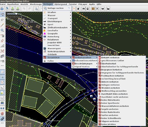
Download all attachments as: .zip
Note:
See TracWiki
for help on using the wiki.