

Editing Help/Action/ImageryAdjust
Attachments (1)
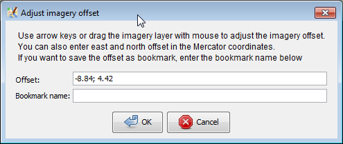
- imagery prompt.png (13.4 KB ) - added by 10 years ago.
Download all attachments as: .zip
Note:
See TracWiki
for help on using the wiki.
Download all attachments as: .zip
Powered by Trac 1.6
By Edgewall Software
.
Server sponsored by FOSSGIS. Visit the OpenStreetMap project at https://www.openstreetmap.org/
Content is available under Creative Commons (CC-BY-SA) and anything since April 2014 also under LGPL license.