

| Version 115 (modified by , 9 years ago) ( diff ) |
|---|
Languages:
Table of Content
JOSM Map Styles
 The JOSM map display can be easily customized with different styles. Many styles are included with JOSM by default.
There are base styles (e.g. JOSM standard or Potlatch 2) that cover a wide range of features each. They can be combined with add-on styles that cover more special topics. See the available styles list below.
Further customization is possible via style options or by creating your own style.
Choose styles
JOSM has three lists of map styles: available styles (all styles from the style repository) → active styles (your favourites) → ☑ chosen styles (actually used for the map painting).
JOSM comes with some styles being in the "active styles" list by default. You can choose styles from this list of "active styles" to be actually used for the map painting by clicking the check box (☑) at the desired style's line
- in the map paint style dialog or
- in the "View" menu ( → "Map paint styles") or
- (less comfortable) in the Map Paint Styles Preferences (see section below)
Note that, unless you are working with add-on styles, likely you want to have only one style ☑ checked at a time.
Activating more styles
To add more styles to your list of "active styles"
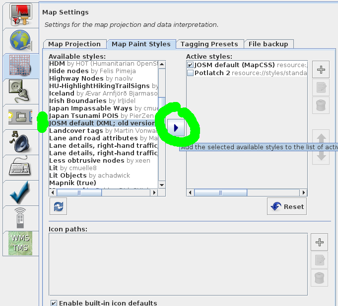
- open the Map Paint Styles Preferences by either
- clicking the
 Settings button in the map style dialog or
- via "View" menu → "Map paint styles" → "Map paint preferences" or
- (less comfortable) via the general preferences window (Menu Edit → Preferences →
 Map Settings (3rd button on the left) → Map Paint Styles (2nd tab))
- clicking the
- select a style in the (left) list of "available styles"
- activate it by clicking the
 blue right arrow button in the centre
- exit and confirm by clicking the OK button


Examples:
- Screenshot showing how to activate the old (XML) JOSM default style
- Let's assume that you're interested in sea maps, then you probably will make use of the style "SeaMap FreieTonne": Just highlight this entry in the "Available Styles" list by clicking on it and press the blue right arrow button in the centre. Now it should be one of your "Active Styles". To actually use it you now need to choose it (check box ☑).
Adding own styles
You can add own styles (from any URL/file) to the list of active styles – for example a styles file which you have created yourself. Just click the  plus sign on the right and enter either path and filename or URL of your style file.
Available styles list
| short description | author | description | version | |
|---|---|---|---|---|
| (Basic) Indoor map | yopaseopor | Visualization of basic tagging in indoor mapping for JOSM More details | 1_2019-03-08 | |
| Address Tags Validator | Antisida, CupIvan, Felis Pimeja, Zverik | Coloring of buildings with or without addr:street, addr:housenumber (deprecated, use 'Coloured streets style' instead.) | 1.18_2020-10-05 | |
| Admin Boundaries | pierzen | Colors Admin Boundary Polygons and nodes. It Helps monitor and edit Boundaries. Parameter options let select Admin levels to show. | 1.6_2024-03-31 | |
| Advertising style, to have icons for main types of advertising devices | Barnes38 | Icons for advertising=billboard, advertising=column, advertising=poster_box, advertising=totem, advertising=board More details | draft.52_2018-07-25 | |
| BAR Damage Assessment | jgc | Displays colored and shaped icons, to show tagging of visible structural strength and damage scale of buildings, according to HHI BAR damage assessment methodology, adapted for OSM More details | 0.6_2018-03-24 | |
| Bench | Klumbumbus | Displays details of bench tags. More details | 1.1.6_2018-03-24 | |
| BesideTheRoad_Speed | kudrdima | Visualization of traffic signs, road characteristics, some of the road infrastructure, traffic restrictions and prohibitions More details | 0.9_2021-09-26 | |
| BNIWR Rendering (standarized symbols) | Aun (Skippern) Johnsen | JOSM rendering of nautical symbols according to BNIWR standard | 0.1 | |
| Boundary_Stone | ajoessen,lutz | Visualization of some historic=* tags | 0.7_2020-10-05 | |
| Building Colors | whatismoss | Colors buildings depending on their building=* tag. More details | 3_2024-03-13 | |
| Building Levels Labels | Sowa1980, Alexander-II | Explicitly shows such tags as roof:levels, building:levels, building:levels:underground, building:min_level in the center of building/building part. | 1.8_2019-05-30 | |
| CEVNI Rendering (standarized symbols) | https://wiki.openstreetmap.org/wiki/User:Kannix | JOSM rendering of nautical symbols according to CEVNI standard More details | 2019-03-10 | |
| Collapsed/damaged buildings | Hjart | Style to classify buildings More details | 0.6_2020-10-05 | |
| Color Ways | Martien, osm username martien-176 (formerly martien-vdg) | Choose your preferred color and line width of building outlines for better visibility on different backgrounds. Also highways and waterways have clearer colors More details | 0.2.34_2024-02-27 | |
| Colorize bicycle routes | Martin Ždila <martin.zdila@…> | Colorize bicycle routes tagged with tag colour. | 0.2.4_2013-11-03 | |
| Colour GPS data | Dirk Stöcker, René Lange | Display points according to GPS status (needs conversion of GPX layer to OSM). | 1.3_2019-11-20 | |
| colour tag | Klumbumbus | Displays ways in the colour of their colour tag. Supported formats are 6 digit RGB hexadecimal (#112233), 3 digit RGB hexadecimal (#123) and CSS color names (green). More details | 4_2022-08-05 | |
| Coloured Buildings.de | geozeisig | Style to classify buildings (german) More details | 1.015_2020-10-05 | |
| Coloured Buildings.en | riiga | Style to classify buildings (English) More details | 1.02_2021-09-18 | |
| Coloured Buildings.sv | riiga | Style to classify buildings (Swedish) More details | 1.01_2021-09-18 | |
| Coloured Buildings.uk | darkonus | Style to classify buildings. Translation of the geozeisig style More details | 0.1_7_2022-05-08 | |
| Coloured Kerbs | te | Draws the pattern for barrier=kerb in different colours based on kerb=* tag. More details | 4_2018-05-19 | |
| Coloured Postcode | geozeisig | Style to ease mapping of Postcode by colouring streets and houses and nodes More details | 2.18_2020-10-05 | |
| Coloured Streets | geozeisig, Klumbumbus | Colouring of buildings, address nodes and streets with the same street name in the same colour. Makes working with addresses a lot easier. Check out the linked page to read how to change some settings of this mappaint style. More details | 3.53.127_2021-04-10 | |
| Coloured Suburb | geozeisig | Coloring of buildings with addr:suburb depending on a CRC algorithm More details | 2.14_2020-10-05 | |
| Colouring helping editing names and refs on streets in Serbia | Pedja | This MapCSS style colors ways according to tags name and ref:RS:street, Style is supposed to be used combined with other styles (Tested in JOSM) More details | 0.11_2021-08-06 | |
| Conscriptionnumbers/streetnumbers | jose1711 | Displays addresses using Czech/Slovak address system More details | 0.2.3_2018-03-24 | |
| Cycleway Styling (BNA) | pkoby | This style was developed to aid in editing for the PeopleforBikes Bicycle Network Analysis (BNA). It adds line decorations to visualize on and off-road cycle tags, as well as relevant on-street parking. Notably, it displays individual sides of the road, and includes cycleway buffers. Deprecated tags are shown in different colors to suggest edits. More details | 0.7_2023-03-14 | |
| Cycleways | cmuelle8 | Standalone style to visualize cycleway=* and bicycle=* of objects, fade everything else. Please turn off JOSM internal style to use it. More details | 1.7_2018-03-24 | |
| destination_sign Relation | mdv | Highlight relation roles from, sign and to | 1.8_2020-10-05 | |
| DigiRoad bus stops | Polyglot | Highlight DigiRoad bus stops with directional arrows More details | 1.6_2018-11-02 | |
| Direction | Hanikatu | Shows the direction of object or light. More details | 1.1.6_2021-06-06 | |
| Direction for traffic signs | Michael Maier (species@osm) | very simple preset to show the “direction” tag of a highway=stop,give_way,traffic_signals More details | 0.1.7 | |
| Disc Golf Course Testing | Negreheb | Colouring and icons for a Disc Golf Course to make mapping it easier. More details | 0.8_2024-03-21 | |
| Enhanced Lane and road attributes | Martin Vonwald,Florin Badita | Visualization of lanes, width, turn lanes, changing the lane, destination, lighting and street lamps, sidewalk, cycletracks, bicycle lanes, bus lanes, psv lanes. Added modification by Florin Badita : - You can see the end of each road segment as a square. - If you modify the lines from ~70 until ~80 and you add your own name, you will be able to see with green your modifications, so that you can inspect the other ways that already have lanes attributes, but were not made by you. - We only show lanes to road categoryes highwer then unclassified, residential. More details | 2.9_2020-04-27 | |
| EPCI (France) | Don-vip | Display French local authorities (known as EPCI) More details | 2.0.5_2016-01-03 | |
| european-waterways-classification-style | kannix | visualisation of navigable waterways in Europe for recreational boating More details | 2021-12-23 | |
| fixme and note | Klumbumbus | Displays fixme=* and note=* coloured. More details | 1.0.2_2020-08-17 | |
| Fixme and notes markers | LLlypuk82, Antisida | This MapCSS style highlights nodes/ways/polygons/multipolygons that contain FIXME/fixme/note and combinations of this tags. This style may be used alone or combined with other styles(Tested in JOSM only). | 0.2_2015-12-15 | |
| FIXME Highlight Warnings | pierzen | This MapCSS style highlights ways/Polygons that contain Fixme attribute and unnamed highways. This style may be used alone or combined with other styles such as Potlatch2 and Mapnik (Tested in JOSM only). | 0.20_2017-10-30 | |
| Forest | igitov | Display detailed description of forest stands & related objects | 0.0.53 | |
| FreieTonne | FreieTonne | Style for FreieTonne-Seamarks More details | 20220108225247 | |
| Greenery details | Jeroen Hoek | Highlight various cultivated greenery features, like shrubbery. | 1.3_2021-08-30 | |
| hazmat | Klumbumbus | Displays hazmat=* and hazmat:water=* coloured. More details | 1.06_2020-10-05 | |
| Health Boundaries | pierzen | Colors Health Boundary Polygons and nodes. It Helps monitor and edit Boundaries. Parameter options let select Health levels to show. More details | 1.10_2021-05-28 | |
| HiDPI Support | Klumbumbus | Allows to scale the nodes size and the font size of the default JOSM mappaint style. More details | 1.11_2021-01-03 | |
| Highway areas | Alex Seidel (Supaplex030) | Visual support for mapping highway areas (area:highway). More details | 1.4_2023-07-26 | |
| Highway Nodes | naoliv | Highlights untagged and unconnected nodes in a way More details | 1.5_2020-10-05 | |
| HU-HighlightHikingTrailSigns | efemm | Highlight hiking trails icons, optimized for Hungarian marking. More details | 1.12_2022-04-25 | |
| Icon tester | Klumbumbus | Helps to test new JOSM icons. More details | 1.1.11_2021-05-15 | |
| iD | Leif Rasmussen | Renders roads, waterways, landuse, and other features like iD. More details | 0.41_2024-03-30 | |
| Incline | Klumbumbus | Display of up/down arrows at the first and last node of ways with incline=*. More details | 2.1.10_2020-09-04 | |
| Incomplete Object Warnings | Timonade | Checks for incomplete data | 2_2022-09-26 | |
| Indoor | Ubica2 Project Team | This JOSM style displays useful information to help indoor map edition. It highlights rooms, corridors, stairs and elevators. In addition, some kind of nodes which are important inside a building will be represented also More details | 0.5 | |
| Inline_Validation | Validate map data as you edit. | 0.2 | ||
| INT 1 Rendering (IHO standarized symbols) PD | Aun (Skippern) Johnsen | JOSM rendering of nautical symbols according to IHO standard INT-1 | 0.2.1 | |
| Japan Impassable Ways | cmuelle8 | Dash out ways tagged with barriers, visualize practicability=* More details | 1.7_2020-10-05 | |
| Japan Tsunami POIS | PierZen | POIS related to Tsunami plus Surface / Roads with damages, obstacles More details | 1.24_2020-10-31 | |
| JOSM default (XML; old version, outdated) | Old version of JOSM default style | XML: 1.10_2020-03-07 | ||
| Kapor2 parcels | jose1711 | Color coding of parcels obtained via Kapor2 plugin (export function) | 0.2_2019-08-15 | |
| Landcover tags | Martin Vonwald | Show landcover and some additional landuse tags | 0.4.14_2020-10-05 | |
| Lane and road attributes | Martin Vonwald | Visualization of lanes, width, turn lanes, changing the lane, destination, lighting and street lamps, sidewalk, cycletracks, bicycle lanes, bus lanes, psv lanes. More details | 2.10-68_2023-10-30 | |
| Lane details, right-hand traffic, arrow version | Wolfgang Hinsch | Shown tags:: lanes, turn lanes, bus lanes, changing the lane, cycleways, sidepaths and lightning | 0.11_2014-06-29 | |
| Lane details, right-hand traffic, color version | Wolfgang Hinsch | Shown tags:: lanes, turn lanes, bus lanes, changing the lane, cycleways, sidepaths and lightning | 0.5_2014-07-02 | |
| Layer checker | Klumbumbus | Display of layer values in JOSM map display. More details | 1.2.17_2021-03-23 | |
| Less obtrusive nodes | xeen | Make nodes smaller when zoomed out. This makes navigating easier when viewing a large area. Also hides icons and text accordingly. More details | 1.9_2018-03-24 | |
| LexxPluss Style | Yasuyuki Miura & Masaya Aso | LexxPluss style to be unicorn More details | 0.2.12_2022-11-03 | |
| light_source | Manuel Hohmann | Icons for light_source=*. | 0.2_2019-08-15 | |
| Lit | cmuelle8 | Show lit=yes/no settings in JOSM map display More details | 2.0.5_2016-01-03 | |
| Lit Objects | achadwick | Supplementary stylesheet which highlights lit and unlit objects by surrounding them with large glows. Works well with the Potlatch 2 base style. | 0.3_2015-06-02 | |
| Mapillary Object Detections | Taylor Smock | Paint style for Mapillary point objects | 1.6_2022-08-24 | |
| Mapnik (true) | MapCSS variant of the OSM Mapnik style (as close as possible to the original). It is not very suitable for real mapping in an editor because nodes and lines without a style are hidden and opaque areas may cover each other. This file is optimized for JOSM and may need some minor changes to work properly with other MapCSS implementations. | 0.1 | ||
| Mapping Accessibility | LorenzoStucchi | Mappatura dell'accessibilità More details | 2.4_2020-11-22 | |
| MapWithAI | Taylor Smock | Visualization of MapWithAI data | 1.19_2021-03-23 | |
| Maxspeed | Rubke, Dirk Stöcker, Vclaw, Klumbumbus | Display maxspeed values of ways in the map view. More details | 2.8.45_2024-04-09 | |
| Missing Maps / Youth Mappers Validators Checks | George Washington University | Some easy settings to find problems that are common in HOT, Missing Maps and Youth Mappers tasks -- namely roads that have a name, which might suspect, and buildings that aren't tagged as building=yes | 1.7 | |
| Modified objects | Sebastian Klein | Highlight modified objects More details | 0.1.14_2021-03-23 | |
| Mountains | lzhl | Indication mountain terrain tags | 0.6_2020-10-05 | |
| MTB | Heiko Woehrle | visualize mtb:scale of objects More details | Styles/MTB | |
| New basic style | Mokrynskyi Pavlo | Style is made in the likeness of the id editor from the web version of openstreetmap.org. Use together with the standard one.Comments and suggestions write to https://github.com/pasharm/New_basic_style_for_JOSM/issues More details | 15_2018-08-04 | |
| New highway colors | Evgeny Katyshev | Make highways color like at standart OSM render More details | 1.0.3_2020-10-05 | |
| new parking features | Mario Schütze | Display the new parking features from "Proposed_features/parking" (see link). More details | 1.4_2018-03-24 | |
| NoFeature | Pierre Béland (PierZen) | No Feature Validation focused style. This style hides the visible and make visible objects hidden in the database with no valid Main tag to facilitate identification of these Features (ie, highway, building, landuse, natural, amenity, shop,etc). This first version is a proof of concept. Comments welcomed. | 0.12_2019-08-15 | |
| Numbered Cycle Node Networks | Polyglot | Highlight Numbered nodes and the routes in between them More details | 1.15_2020-05-14 | |
| Numbered Walking Node Networks | Escada | Highlight numbered nodes and the routes in between them More details | 1.5_2020-05-14 | |
| Open Nederlands Wegenbestand (OpenNWB) | dr.ir. Jeroen van der Gun (Fileradar) | Interactieve kaartstijl met wegkenmerken voor de Lage Landen More details | ||
| OpenRailwayMap additional icons and symbols for editing | Nakaner | Style for a assisting mapping of railway information in JOSM. Not suitable for map rendering. More details | 0 | |
| OpenRailwayMap Electrification layer | Dakon | Style for a electrification layer railroad network map. More details | 0 | |
| OpenRailwayMap infrastructure standard layer | rurseekatze | Style for a infrastructure standard layer railroad network map. More details | 0 | |
| OpenRailwayMap maxspeed layer | rurseekatze | Style for a maxspeed layer of the railroad network. More details | 0 | |
| OpenRailwayMap signalling layer | rurseekatze | Style for a signalling layer railroad network map. More details | 0 | |
| operator and ref | "Sowa1980, Панкратов Александр Владимирович | Explicitly shows tags like operator, ref in center of area, node | 1.00_2021-12-08 | |
| orientation for traffic signs | Stéphane Péneau (Carto'Cité) | simple preset to show the “direction” tag of a highway=stop,give_way,traffic_signals More details | 0.3.1 | |
| OSMC Hiking | Martin Ždila <martin.zdila@…> | Colorize marked hiking trails using OSMC tagging schema. | 0.2.3_2013-11-03 | |
| OSMC Hiking (optimized for SK/CZ/PL) | Martin Ždila <martin.zdila@…> | Colorize marked hiking trails using OSMC tagging schema. Optimized for SK/CZ/PL marking. | 0.2.2_2013-11-03 | |
| Osmic | nebulon42 | Osmic icons for JOSM More details | 0.1 | |
| Paddenstoel guidepost | vsandre | Show a special icon for a paddenstoel guidepost. More details | 1.8_2020-10-05 | |
| Parking lanes | Sebastian Klemm, Kay Drangmeister, Jeroen Hoek, riiga, Supaplex030 | Parking lanes along roads and parking/stopping restrictions. More details | 1.24_2022-12-11 | |
| Places_ES_styles | Iago Casabiell González | Displays nodes with [place=*] for Spain. | 1.0.4_2020-01-15 | |
| plan.at ToDos | simon04 | Highlight problematic objects from plan.at import More details | 1.6_2020-10-05 | |
| potlach2 access | iav | Visualizes access tag on highways. Made only for Potlach2 JOSM style | 0.2_2012-11-30 | |
| Potlatch 2 | Richard Fairhurst, conversion by Guillaume Rischard | Potlatch 2 core stylesheet, forked, patched, converted and vectorised. More details | 1.12_2023-12-30 | |
| Power | FLacombe | A more detailed style for various power facilities and features | 0.4.5_2020-04-17 | |
| Power Mapping Additions | SSherpa+prabhasp | Special icons for facilitating mapping of power lines; in development. More details | 0.35_2020-10-31 | |
| PPWBC Rendering (standarized symbols) | Aun (Skippern) Johnsen | JOSM rendering of nautical symbols according to PPWBC standard | 0.1 | |
| Priority Road | Klumbumbus | Displays priority_road=* coloured. More details | 1.1.9_2020-10-05 | |
| PTStops | FiliusMartii | Highlight important information regarding Public Transportation according to public transport version 2 More details | 1.0.4_2016-01-19 | |
| Public Transport | Polyglot | Highlight important information regarding Public Transport More details | 2.10_2018-03-24 | |
| Public Transport v2 | Ialokim | Highlight important information regarding public transport according to public transport version 2. More details | 1.5.9_2023-12-28 | |
| Recycling Materials | Klumbumbus | Displays recycling material on recycling nodes. More details | 1.0.6_2020-10-05 | |
| RIWR Rendering (standarized symbols) | Aun (Skippern) Johnsen | JOSM rendering of nautical symbols according to RIWR standard | 0.1 | |
| sac_scale | Klumbumbus | Displays sac_scale=* coloured. More details | 1.015_2020-10-05 | |
| Schools | Polyglot | Highlight important information for importing schools and validation More details | 1.4_2019-08-15 | |
| Show parcel lockers | Eifelkobold! | Show an icon for parcel lockers. More details | 0.1_2022-07-27_Antweiler | |
| ShowID | Klumbumbus | This style is for a layer with the .osm file from Keypad-Mapper 3. It shows the (positive) IDs of the housenumbers. So you can see the sequence of the nodes, how you recorded them. For more information how to use this style see the link. More details | 1.1.18_2021-11-17 | |
| Sidewalks | Cobra | Visualizes the sidewalk attribute of highways. sidewalk=* is rendered as a thick dashed line, separately mapped sidewalks tagged footway=sidewalk are rendered thicker. More details | 0.6_2019-04-09 | |
| Sidewalks and footways (with knobs on) | Jeroen Hoek | Useful for pedestrian affairs. Visualizes the sidewalk, sidewalk:both, sidewalk:left, and sidewalk:right attribute of highways, and renders various highway=footway types in different patterns. Ways that do not permit pedestrian use are made translucent. More details | 1.16_2023-12-17 | |
| Sidewalks Plus | Cobra;Aharvey | Visualizes the sidewalk attribute of highways. sidewalk=* is rendered as a thick dashed line, separately mapped sidewalks tagged footway=sidewalk are rendered thicker. More details | 6_2021-07-01 | |
| Simple building tags | heilbron | Visualize basic simple 3D building tags, e.g. (building) colour, building:levels, roof:levels. Improves speed of entering gathered ground truth into the map. More details | 1.21_2020-10-05 | |
| Simple roof tags | heilbron | Visualize the presence of some simple roof tags (shape & colour) More details | 1.14_2021-06-21 | |
| Speedlimit Signs | Martin Koppenhoefer | Display maxspeed on nodes by Speedlimit signs. | 3.13_2019-05-19 | |
| Station names on subway entrances | Alexander-II | Shows station names on subway entrances via stop_area relation More details | 0.1.4_2018-10-15 | |
| Streets Have No Name | Yann Coupin | Could be a U2 song: highlights where the streets have no name | 0.4_2020-10-05 | |
| Surface | cmuelle8 | Visualize surface=* of objects More details | 1.25_2019-07-18 | |
| Surface - Data Entry | AndrewBuck | This styling is intended for data entry of road surface tags from aerial imagery. The style not only shows the status and value of the surface tag, but also refrains from drawing directly on the road allowing a clear view of the road surface in the imagery to allow for easier editing/checking of the surface values. More details | 1.0.9_2018-03-24 | |
| tiger:reviewed=no | Klumbumbus | Displays an underlay for ways tagged with tiger:reviewed=no. More details | 1.4_2018-03-24 | |
| TM Tasks Grid | peculiar theater | Style the downloadable Tasks Grid from the Tasking Manager to present task information on the JOSM map view. More details | 2022.11a | |
| Traffic Signs_AFR | yopaseopor | Display all the signs included in OSM database for Africa. Specially recommended with roadsigns plugin and traffic_signs presets. More details | 5.2019-02-24 | |
| Traffic Signs_AME | yopaseopor | Display all the signs included in OSM database in America. Specially recommended with roadsigns plugin and traffic_signs presets. More details | 4.2018-05-31 | |
| Traffic Signs_BY | yopaseopor | Display all the signs included in OSM database of Belarus. Specially recommended with roadsigns plugin and traffic_signs presets. More details | 3.2023-11-12 | |
| Traffic Signs_CO | yopaseopor | Display all the signs included in OSM database for Colombia. Specially recommended with roadsigns plugin and traffic_signs presets. More details | 5.2023-07-20 | |
| Traffic Signs_DE | yopaseopor | Display all the signs included in OSM database for Germany. Specially recommended with roadsigns plugin and traffic_signs presets. More details | 6.2023-11-01 | |
| Traffic Signs_ES | yopaseopor | Display all the signs included in OSM database for Spain. Specially recommended with roadsigns plugin and traffic_signs presets. More details | 5.2023-12-12 | |
| Traffic Signs_EUR_OC | yopaseopor | Display all the signs included in OSM database for West Europe (Austria, Andorra, Belgium, Switzerland, Czech Republic, Germany, Denmark, Spain, France, United Kingdom, Ireland, Italy, The Nederlands and Portugal, ). Specially recommended with roadsigns plugin and traffic_signs presets. More details | 4.2019-01-04 | |
| Traffic Signs_EUR_OR | yopaseopor | Display all the signs included in OSM database for East Europe (Belarus, Estonia, Finland, Hungary, Iceland, Norway, Poland, Russia, Serbia, Sweden, Slovakia, Turkey, and Ukraine). Specially recommended with roadsigns plugin and traffic_signs presets. More details | 5.2019-01-04 | |
| Traffic Signs_FI | yopaseopor | Display all the signs included in OSM database of Finland. Specially recommended with roadsigns plugin and traffic_signs presets. More details | 3.2023-11-05 | |
| Traffic Signs_FR | yopaseopor | Display all the signs included in OSM database of France. Specially recommended with roadsigns plugin and traffic_signs presets. More details | 3.2023-11-18 | |
| Traffic Signs_NL | yopaseopor | Display all the signs included in OSM database for the Netherlands. Specially recommended with roadsigns plugin and traffic_signs presets. More details | 5.2023-11-05 | |
| Traffic Signs_PAC | yopaseopor | Display all the signs included in OSM database in Pacific Zone (Australia, China, Indonesia, Israel, Japan and South Korea). Specially recommended with roadsigns plugin and traffic_signs presets. More details | 4.2019-02-26 | |
| Traffic Signs_PH | Hike&Map | Display all the signs included in OSM database for the Philippines. Specially recommended with roadsigns plugin and traffic_signs presets. More details | 1.6_2023-06-04 | |
| Traffic Signs_US | yopaseopor | Display all the signs included in OSM database of United States. Specially recommended with roadsigns plugin and traffic_signs presets. More details | 3.2023-11-13 | |
| Tree-Crown_Diameter | AndrewBuck | This style shows which trees have a tree crown diameter entered on them and if so, attempts to show the trees relative to their size. More details | 1.0.5_2019-04-21 | |
| Ukraine Road Network | Anton Melnichuk | This style aids in mapping the Ukrainian road network as recognised by Ukrainian law. It facilitates error correction, intersection identification, and detection of gaps in the road network. More details | 1.8_2024-02-05 | |
| waterways | Pierre Béland (pierzen) | this « Blue Map Style » Colors water and waterways features and caracteristics and flags potential errors with red triangles (ie disconnected segments, transition from river to stream, unclosed polygon). Styling of Waterways and natural features characteristics (ie. tunnel, bridge, intermitent, abandoned) looks alike OSM Carto Style. Setting options to «Show Flags - potential connection errors» and « Show Water / Waterways names ». | 1.10_2023-11-08 | |
| Wheelchair Routing Attributes | Michael Maier (species@osm) | A Style for highlighting wheelchair-relevant Tags | 1.0.20 | |
| Whitewater | pankdm | Visualization of some whitewater=* tags | 0.5_2020-10-05 | |
| Валидатор зданий | Alexander Istomin https://www.openstreetmap.org/user/Alexander-II и Панкратов Александр Владимирович https://www.openstreetmap.org/user/Sowa1980 | Валидатор зданий | 1.02_2019-05-18 | |
Create your own style
You don't like the standard style? Change it to your own liking:
- In the map paint style dialog, right click one of the styles and select
 "save as...". A copy will be added to the list of styles. You can open the file in a text editor and reload after doing some changes.
- Or create a style from scratch and add it in the JOSM mappaint preferences.

JOSM supports two formats to define a style:
- JOSM XML
- The previously traditional style format in JOSM (still functional). The old standard style contains some documentation.
- MapCSS
-
Style language similar to CSS originally developed for Potlatch 2, but aims to be a standard for map styles.
- General information can be found in the osm wiki.
- A Short tutorial should get you started.
- The JOSM implementation reference lists the supported features in more detail.
Style files with different formats are compatible, they can be loaded at the same time.
Make your style available to other users
- Either edit this wiki page and add URLs for new style files to the list at the top.
- Note: Only URLs with file-extension (e.g. *.mapcss, *.xml, *.zip, *.php) are supported.
- Or create a wiki page similar to Styles/LegacyStandard (XML) or Styles/Modified (MapCSS).
- for automatic version adjustment you can use two internal variables (
"1.[[revision]]_[[date]]" --> 1.13_2011-02-24):[[revision]]- is the latest version number of the wiki page[[date]]- is the date of the last edit
- Note: Spam filter prohibits adding many external (icon) links. Please, if possible, attach icons to the wiki page (see below).
- for automatic version adjustment you can use two internal variables (
In both cases, the new style will be automatically listed in the table above after a few minutes. Then it will also be available in the JOSM mappaint preferences (after clicking the reload button).
Icons
.png and .svg files are supported.
Icon handling
There are different forms to handle icons:
- Icons distributed with JOSM can be entered directly with the path (relative to JOSM's internal image directory).
- Use a path relative to your local style file.
- New icons can be directly referenced using a http-link. These are downloaded and cached internally.
- Since JOSM revision 2289 zip files are supported.
- The zip file must contain at least one file with extension xml (or mapcss).
- Icon names and path are relative to the topmost zip directory.
- If there are multiple XML files, a file with "style" in the name is preferred (to allow packaging styles and presets in one archive).
- Since JOSM revision 4713 inline encoding as described in RFC 2397 is supported.
- Example for PNG:
data:image/png;base64,...databytes... - Example for SVG:
data:image/svg+xml;base64,...databytes... - More information about
data:image/...in JOSM.
- Example for PNG:
- When the JOSM wiki is used for designing of new styles you have some additional options:
- Each file attached to the wiki page is automatically included in the zip file downloaded by JOSM.
- If you don't want a file in the zip file, add the text (NOZIP) in the description of the attachment.
- If you add a zip file and want its contents included, you may add (EXTRACT) in the description of the attachment.
- The server automatically switches from download of single file to zip download when files are attached.
Styles managed in JOSM wiki
- Styles/AddressValidator
- Styles/Admin_Boundaries
- Styles/AdvertisingStyle
- Styles/BAR-damage-assessment
- Styles/Bench
- Styles/BesideTheRoad_Speed
- Styles/BuildingColors
- Styles/Building_Levels_Labels
- Styles/ColorWays
- Styles/ColourGPSData
- Styles/ColourTag
- Styles/Coloured_Kerbs
- Styles/Coloured_Postcode
- Styles/Coloured_Streets
- Styles/Coloured_Suburb
- Styles/Coloured_buildings
- Styles/Coloured_buildings_en
- Styles/Coloured_buildings_sv
- Styles/Coloured_buildings_uk
- Styles/ConscriptionStreetnumber
- Styles/Cycleways
- Styles/CyclewaysStylingBNA
- Styles/DestinationSignRelation
- Styles/DigiRoadBusStops
- Styles/Direction
- Styles/DiscGolfCourse
- Styles/Enhanced_Lane_and_Road_Attributes
- Styles/Fixme
- Styles/FixmeAndNote
- Styles/FrenchEPCI
- Styles/Greenery
- Styles/Guidepost
- Styles/HU-HighlightHikingTrailSigns
- Styles/HealthBoundary
- Styles/HiDPISupport
- Styles/HighwayAreas
- Styles/Highway_Nodes
- Styles/Historic_Stones
- Styles/IconTester
- Styles/Incline
- Styles/JP-Desaster
- Styles/JP-Tsunami
- Styles/Kapor2Parcels
- Styles/Landcover
- Styles/Lane_and_Road_Attributes
- Styles/Lane_features
- Styles/Lane_features_ryg
- Styles/LayerChecker
- Styles/LegacyStandard
- Styles/LessObtrusiveNodes
- Styles/LexxPlussStyle
- Styles/Lit
- Styles/LitObjects
- Styles/MTB
- Styles/MapWithAI
- Styles/MapillaryDetections
- Styles/MappingAccessibility
- Styles/Maxspeed
- Styles/MaxspeedIcons
- Styles/Modified
- Styles/Mountains
- Styles/NewHighwayColors
- Styles/NewParkingFeatures
- Styles/NoFeature
- Styles/Noname
- Styles/NumberedCycleNodeNetworks
- Styles/NumberedWalkingNodeNetworks
- Styles/Osmc
- Styles/OsmcSKCZPL
- Styles/PTStops
- Styles/ParcelLocker
- Styles/ParkingLanes
- Styles/Ph_Typhoon
- Styles/PhilippinesTrafficSigns
- Styles/Places_ES_styles
- Styles/Potlach2_access
- Styles/Potlatch2
- Styles/Power
- Styles/PowerMapping
- Styles/PriorityRoad
- Styles/PublicTransport
- Styles/PublicTransportV2
- Styles/RU-SubwayEntranceLabeling
- Styles/RecyclingMaterials
- Styles/Schools
- Styles/SerbianStreetNamesAndRefsColouring
- Styles/ShowID
- Styles/Sidewalks
- Styles/SidewalksAndFootways
- Styles/SidewalksPlus
- Styles/SimpleBuildingTags
- Styles/SimpleRoofTags
- Styles/SlovakiaBicycleRoutes
- Styles/Surface
- Styles/Surface-DataEntry
- Styles/TigerReviewedNo
- Styles/TreeCrownDiameter
- Styles/UkraineRoadNetwork
- Styles/Waterways
- Styles/Whitewater
- Styles/hazmat
- Styles/iD
- Styles/light_source
- Styles/plan.at
- Styles/sac_scale
Rendering
Mappaint renders the map data so it looks much more like a map (colors, icons, annotations, ...) - compared to the JOSM wireframe mode.
Nodes
Most nodes that correspond to tags in the Map Features page will show an appropriate icon, e.g. a white "P" on blue ground for amenity=parking.
There are some special icons for missing/incomplete things:
![]() missing icon
missing icon
We don't have the right icon for every node tag in map features yet, e.g. icons for most natural=* tags are still missing. If you encounter such a "missing icon", feel free to create a nice 16*16 pixel icon that matches the tag. To submit your work, open a new ticket and add your image or zip archive as attachment.
 warning icon
The corresponding tag was once used but is no longer recommended to be used - or - it is not suitable for a node, e.g. highway=motorway just doesn't make sense on a node. Probably not all deprecated tags will show this icon.
Ways
Most ways that correspond to tags in the map features page will get special color, thickness and line style (e.g. dashed lines for railways).
Areas
Areas are ways that form a sort of ring. Most areas that corresponds to tags in the map features page will be filled with a special color (the filling will be transparent to some degree).
Advanced Preferences
Some styles may have options. They are available via a right click on the style's entry inside the map paint style dialog window. E.g. JOSM's current default map style (MapCSS) has the option to disable the "less obtrusive" nodes at low zoom levels.
In addition, you can use the following hidden preferences:
mappaint.fillalpha- alpha "opacity level", that is used to fill areas. An integer value between 0 (transparent) and 255 (solid) with the default of 50.
mappaint.fillareas(show areas)- 10000000 (default) - areas will be filled with their corresponding colour and name will be rendered
- 0 - areas will be surrounded by lines only and name will not be rendered
- any other number - areas will be filled with their corresponding colour and name will be rendered at any zoom level below the given number in meters
mappaint.showicons- select whether icons are shown - same values as
mappaint.fillareas
- select whether icons are shown - same values as
mappaint.shownames- select whether names are shown - same values as
mappaint.fillareas
- select whether names are shown - same values as
mappaint.strokes- select whether strokes or full lines are used - same values as
mappaint.fillareas
- select whether strokes or full lines are used - same values as
mappaint.useRealWidth- true - ways will change width corresponding to the real width in meters set in the elemstyle.xml file
- false (default) - ways will have the same width on every zoom level
mappaint.zoomLevelDisplay- true - elements visibility depends on zoom level
- false (default) - all elements are displayed
mappaint.fontsize- size of mappaint texts (default=8)
Back to main help
Attachments (3)
-
Mappaint_deprecated.png
(650 bytes
) - added by 15 years ago.
deprecated icon
-
Mappaint_no_icon.png
(335 bytes
) - added by 15 years ago.
no icon
-
addstyle.gif
(1.8 MB
) - added by 9 years ago.
How to add a map paint style
Download all attachments as: .zip