node[amenity=restaurant]
{
    icon-image: "presets/food/restaurant.svg";
    text: auto;
}

node[amenity=restaurant]
{
icon-image: "presets/food/restaurant.svg";
text: auto;
}
|
|
way[highway=residential]
{
    width: 4;
    color: lightgray;
}
|
 |
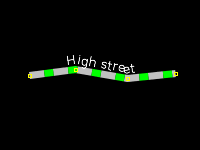
way[highway=living_street]
{
    width: 7;
    color: #c0c0c0;
    dashes: 15,9;
    dashes-background-color: #00ff00;

    text: "name";
    text-position: line;
    text-offset: 9;
    font-size: 12;
    font-color: lightyellow;
}
|
 |
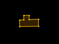
area[building]
{
    fill-color: orange;
}
|
 |
area[landuse=forest], area[natural=wood]
{
    fill-image: "http://trac.openstreetmap.org/export/25265/applications/rendering/mapnik/symbols/forest.png";
    fill-opacity: 0.8;

    text: auto;
    text-position: center;
}
|
 |